Ap Lei Pai
| 鴨脷排 | |
|---|---|
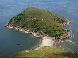 Ap Lei Pai Island as seen from Ap Lei Chau Island. A tombolo connects the two islands. | |
| Geography | |
| Coordinates | 22°13′50.5554″N 114°9′40.4994″E / 22.230709833°N 114.161249833°ECoordinates: 22°13′50.5554″N 114°9′40.4994″E / 22.230709833°N 114.161249833°E |
| Adjacent bodies of water |
East Lamma Channel Aberdeen Channel |
| Administration | |
| District | Southern District |
| Demographics | |
| Population | Uninhabited |
| Ap Lei Pai | |||||||||
| Traditional Chinese | 鴨脷排 | ||||||||
|---|---|---|---|---|---|---|---|---|---|
| |||||||||
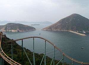
Ap Lei Pai (left) and Ap Lei Chau (right); taken from Ocean Park. Lamma Island is visible in the background.
Ap Lei Pai (Chinese: 鴨脷排) is an uninhabited island in Hong Kong, linked to the south of Ap Lei Chau in Hong Kong. It is located between the East Lamma Channel and Aberdeen Channel. It is under the administration of the Southern District.
See also
External links
| Wikimedia Commons has media related to Ap Lei Pai. |
This article is issued from
Wikipedia.
The text is licensed under Creative Commons - Attribution - Sharealike.
Additional terms may apply for the media files.