Prang Ku District
| Prang Ku ปรางค์กู่ | |
|---|---|
| Amphoe | |
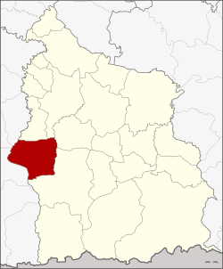 Amphoe location in Sisaket Province | |
| Coordinates: 14°51′24″N 104°2′24″E / 14.85667°N 104.04000°ECoordinates: 14°51′24″N 104°2′24″E / 14.85667°N 104.04000°E | |
| Country | Thailand |
| Province | Sisaket |
| Area | |
| • Total | 285.475 km2 (110.223 sq mi) |
| Population (2005) | |
| • Total | 68,208 |
| • Density | 238.9/km2 (619/sq mi) |
| Time zone | UTC+7 (ICT) |
| Postal code | 33170 |
| Geocode | 3307 |
Prang Ku (Thai: ปรางค์กู่, pronounced [prāːŋ kùː]) is a district (amphoe) in the western part of Sisaket Province, northeastern Thailand.
Geography
Neighboring districts are (from the north clockwise) Huai Thap Than, Uthumphon Phisai, Wang Hin, and Khukhan of Sisaket Province, Si Narong, Sikhoraphum. and Samrong Thap of Surin Province.
History
The minor district (king amphoe) Prang Ku was established on 1 January 1961, when it was split off from Khukhan District. The district is named after Prang Samong in Ban Ku. On 17 July 1963 it was upgraded to a full district.
Administration
The district is divided into 10 sub-districts (tambon), which are further subdivided into 141 villages (muban). Prang Ku is a township (thesaban tambon) which covers parts of tambon Phimai and Phimai Nuea. There are a further 10 tambon administrative organizations (TAO).
| No. | Name | Thai name | Villages | Pop. | |
|---|---|---|---|---|---|
| 1. | Phimai | พิมาย | 13 | 7,306 | |
| 2. | Ku | กู่ | 17 | 12,182 | |
| 3. | Nong Chiang Thun | หนองเชียงทูน | 19 | 9,439 | |
| 4. | Tum | ตูม | 11 | 6,193 | |
| 5. | Samo | สมอ | 17 | 7,522 | |
| 6. | Pho Si | โพธิ์ศรี | 14 | 5,519 | |
| 7. | Samrong Prasat | สำโรงปราสาท | 17 | 6,893 | |
| 8. | Du | ดู่ | 13 | 4,794 | |
| 9. | Sawai | สวาย | 10 | 4,082 | |
| 10. | Phimai Nuea | พิมายเหนือ | 10 | 4,278 |