Amami Guntō National Park
| Amami Guntō National Park | |
|---|---|
| 奄美群島国立公園 | |
|
IUCN category II (national park) | |
 | |
| Location | Kagoshima, Japan |
| Coordinates | 27°46′48″N 128°54′54″E / 27.78°N 128.915°ECoordinates: 27°46′48″N 128°54′54″E / 27.78°N 128.915°E |
| Area | 421.81 km2 (162.86 sq mi) |
| Established | 7 March 2017 |
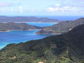
Amami Guntō National Park (奄美群島国立公園 Amami Guntō Kokuritsu Kōen) is a national park in Kagoshima Prefecture, Japan. Established in 2017, the park comprises a land area of 42,181 ha (104,230 acres) in the municipalities of Amagi, Amami, China, Isen, Kikai, Setouchi, Tatsugō, Tokunoshima, Uken, Wadomari, Yamato, and Yoron, together with 33,082 ha (81,750 acres) of the surrounding waters. Subsuming the former Amami Guntō Quasi-National Park, the designation of the new National Park, alongside that of Yanbaru National Park, is part of the movement to have Amami-Oshima Island, Tokunoshima Island, the northern part of Okinawa Island and Iriomote Island inscribed on the UNESCO World Heritage List.[1][2][3][4]
See also
References
- ↑ 奄美群島国立公園について [About Amami Guntō National Park] (in Japanese). Ministry of the Environment. 7 March 2017. Retrieved 11 March 2017.
- ↑ 奄美群島国立公園(仮称)の指定及び公園計画の決定等に関する意見の募集について [Consultation about the Establishment of Amami Guntō National Park] (in Japanese). Ministry of the Environment. 6 October 2016. Retrieved 11 March 2011.
- ↑ "Amami-Oshima Island, Tokunoshima Island, the northern part of Okinawa Island and Iriomote Island". UNESCO. Retrieved 11 March 2017.
- ↑ "Amami Islands eyed as 34th national park". The Japan Times. 4 October 2016. Retrieved 11 March 2017.
External links
- (in Japanese) Map of Amami Guntō National Park

This article is issued from
Wikipedia.
The text is licensed under Creative Commons - Attribution - Sharealike.
Additional terms may apply for the media files.