Sobo-Katamuki Quasi-National Park
| Sobo-Katamuki Quasi-National Park | |
|---|---|
| 祖母傾国定公園 | |
 | |
 Map of Japan | |
| Location | Ōita/Miyazaki Prefectures, Japan |
| Coordinates | 32°43′41″N 131°24′36″E / 32.728°N 131.41°ECoordinates: 32°43′41″N 131°24′36″E / 32.728°N 131.41°E[1] |
| Area | 220 km2 (85 sq mi) |
| Established | 25 March 1965 |
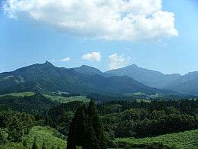
Sobo-Katamuki Quasi-National Park (祖母傾国定公園 Sobo-Katamuki Kokutei Kōen) is a Quasi-National Park in Ōita and Miyazaki Prefectures, Japan. Established in 1965, the park derives its name from Mount Sobo (1,756 m (5,761 ft)) and Mount Katamuki (傾山) (1,602 m (5,256 ft)).[2][3] The Quasi-National Park borders two homonymous Prefectural Parks, namely the Sobo Katamuki Prefectural Natural Park (Ōita) and Sobo Katamuki Prefectural Natural Park (Miyazaki).[4][5]
Related municipalities
See also
| Wikimedia Commons has media related to Sobo-Katamuki Quasi-National Park. |
References
- ↑ "Sobo - Katamuki Quasi National Park". protectedplanet.net.
- ↑ "壱岐対馬/九州中央山地/日豊海岸/祖母傾". National Parks Association of Japan. Archived from the original on 23 March 2012. Retrieved 7 February 2012.
- ↑ "List of National Parks". Ministry of the Environment. Retrieved 7 February 2012.
- 1 2 "Designation of the Natural Parks of Miyazaki Prefecture" (PDF). Miyazaki Prefecture. Retrieved 7 February 2012.
- 1 2 "Designation of the Natural Parks of Ōita Prefecture" (PDF). Ōita Prefecture. Archived from the original (PDF) on 16 January 2004. Retrieved 7 February 2012.
External links
- Map of Sobo-Katamuki Quasi-National Park (Miyazaki Prefecture)
- Maps of Sobo-Katamuki Quasi-National Park (Ōita Prefecture)
This article is issued from
Wikipedia.
The text is licensed under Creative Commons - Attribution - Sharealike.
Additional terms may apply for the media files.