Sanin Kaigan National Park
| Sanin Kaigan National Park | |
|---|---|
| 山陰海岸国立公園 | |
|
IUCN category II (national park) | |
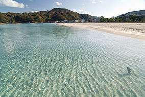 Takeno Beach | |
| Location | San'in, Japan |
| Coordinates | 36°33′45″N 136°21′44″E / 36.5626°N 136.3623°ECoordinates: 36°33′45″N 136°21′44″E / 36.5626°N 136.3623°E |
| Area | 87.83 km² |
| Established | 15 July 1963 |
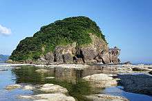
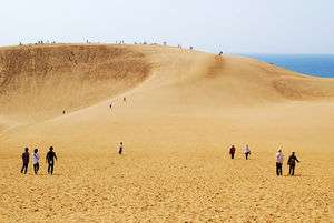
Sanin Kaigan National Park (山陰海岸国立公園 San'in Kaigan Kokuritsu Kōen) is a National Park in Tottori, Hyōgo, and Kyōto Prefectures, Japan.[1] Established in 1963, the park runs continuously along the Sea of Japan coast from Tottori to Kyōtango.[2][3][1] The park covers 87.83 km². Sanin Kaigan National Park is known for its numerous inlets, rock formations, islands, and caves.[1]
The entire area of this national park is a part of San'in Kaigan Global Geopark.
Sites of interest
Noted fauna and flora
- Pinus thunbergii, the Japanese black pine
- Japanese martin
- Black-tailed gull[1]
Related municipalities
See also
| Wikimedia Commons has media related to Sanin Kaigan National Park. |
References
- 1 2 3 4 "San'in Coast National Park". Encyclopedia of Japan. Tokyo: Shogakukan. 2012. Archived from the original on 2007-08-25. Retrieved 2012-04-12.
- ↑ "San'inkaigan National Park". Natural Parks Foundation. Retrieved 4 February 2012.
- ↑ Sutherland, Mary; Britton, Dorothy (1995). National Parks of Japan. Kodansha. pp. 131–3.
- ↑ "San'inkaigan National Park". Ministry of the Environment. Archived from the original on 8 February 2012. Retrieved 4 February 2012.
- ↑ "Sanin Kaigan National Park". Kyōto Prefecture. Retrieved 4 February 2012.
- ↑ "山陰海岸国立公園". Tottori Prefecture. Retrieved 4 February 2012.
- ↑ "Sanin Kaigan". Hyōgo Prefecture. Retrieved 4 February 2012.
- ↑ "Sanin Kaigan National Park - Basic Information". Ministry of the Environment. Archived from the original on 28 January 2013. Retrieved 4 February 2012.
External links
- (in English) Sanin Kaigan National Park
- (in Japanese) Sanin Kaigan National Park
- Map of Sanin Kaigan National Park

This article is issued from
Wikipedia.
The text is licensed under Creative Commons - Attribution - Sharealike.
Additional terms may apply for the media files.