Kita-Nagato Kaigan Quasi-National Park
| Kita-Nagato Kaigan Quasi-National Park | |
|---|---|
| 北長門海岸国定公園 | |
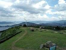
 Omijima | |
 Map of Japan | |
| Location | Yamaguchi Prefecture, Japan |
| Nearest city | Hagi |
| Coordinates | 34°26′56″N 131°25′34″E / 34.449°N 131.426°ECoordinates: 34°26′56″N 131°25′34″E / 34.449°N 131.426°E[1] |
| Area | 80.21 km2 (30.97 sq mi) |
| Established | November 1, 1955 |
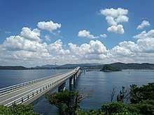
One of famous sightseeing in Kita-Nagato Kaigan Kokutei Kōen. This bridge's name is Tsunoshima Ohashi
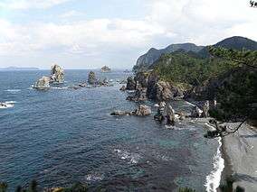
One of famous sightseeing in Kita-Nagato Kaigan Kokutei Kōen. This is Senjojiki.
Kita-Nagato Kaigan Quasi-National Park (北長門海岸国定公園 Kita-Nagato Kaigan Kokutei Kōen) is a Quasi-National Park on the coast of Yamaguchi Prefecture, Japan.[2][3] It was founded on 1 November 1955 and has an area of 80.21 km2 (30.97 sq mi).[4]
See also
| Wikimedia Commons has media related to Kitanagato Kaigan Quasi-National Park. |
References
- ↑ "Kita - Nagato Kaigan Quasi National Park". protectedplanet.net.
- ↑ "北長門海岸国定公園". Ministry of the Environment. Archived from the original on 5 June 2011. Retrieved 10 May 2011.
- ↑ "北長門海岸/秋吉台/剣山/室戸阿南海岸". National Parks Association of Japan. Retrieved 10 May 2011.
- ↑ "List of National Parks". Ministry of the Environment. Retrieved 10 May 2011.
This article is issued from
Wikipedia.
The text is licensed under Creative Commons - Attribution - Sharealike.
Additional terms may apply for the media files.