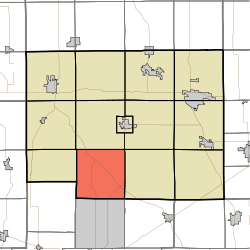
Noble Township, Noble County, Indiana
| Noble Township | |
|---|---|
| Township | |
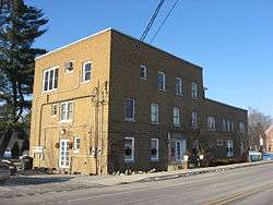 The Luckey Hospital in Wolf Lake | |
 | |
| Coordinates: 41°18′48″N 85°28′41″W / 41.31333°N 85.47806°WCoordinates: 41°18′48″N 85°28′41″W / 41.31333°N 85.47806°W | |
| Country | United States |
| State | Indiana |
| County | Noble |
| Government | |
| • Type | Indiana township |
| Area | |
| • Total | 35.15 sq mi (91.0 km2) |
| • Land | 33.78 sq mi (87.5 km2) |
| • Water | 1.37 sq mi (3.5 km2) |
| Elevation[1] | 912 ft (278 m) |
| Population (2010) | |
| • Total | 3,094 |
| • Density | 91.6/sq mi (35.4/km2) |
| Time zone | UTC-5 (Eastern (EST)) |
| • Summer (DST) | UTC-4 (EDT) |
| Area code(s) | 260 |
| FIPS code | 18-54108[2] |
| GNIS feature ID | 453672 |
Noble Township is one of thirteen townships in Noble County, Indiana. As of the 2010 census, its population was 3,094 and it contained 1,642 housing units.[3]
History
The former Luckey Hospital was listed on the National Register of Historic Places in 2013.[4]
Geography
According to the 2010 census, the township has a total area of 35.15 square miles (91.0 km2), of which 33.78 square miles (87.5 km2) (or 96.10%) is land and 1.37 square miles (3.5 km2) (or 3.90%) is water.[3]
Unincorporated towns
- Bear Lake at 41°19′21″N 85°31′06″W / 41.3225017°N 85.5183691°W
- Burr Oak at 41°19′23″N 85°25′59″W / 41.3231034°N 85.4330352°W
- Merriam at 41°17′14″N 85°26′04″W / 41.2872696°N 85.4344239°W
- Wolf Lake at 41°20′06″N 85°29′45″W / 41.3350476°N 85.4958146°W
(This list is based on USGS data and may include former settlements.)
References
- ↑ "US Board on Geographic Names". United States Geological Survey. 2007-10-25. Retrieved 2008-01-31.
- ↑ "American FactFinder". United States Census Bureau. Archived from the original on September 11, 2013. Retrieved 2008-01-31.
- 1 2 "Population, Housing Units, Area, and Density: 2010 - County -- County Subdivision and Place -- 2010 Census Summary File 1". United States Census. Retrieved 2013-05-10.
- ↑ "National Register of Historic Places Listings". Weekly List of Actions Taken on Properties: 3/18/13 through 3/22/13. National Park Service. 2013-03-29.
External links
Municipalities and communities of Noble County, Indiana, United States | ||
|---|---|---|
| Cities | ||
| Towns | ||
| Townships | ||
| CDP | ||
| Unincorporated communities | ||
| Footnotes | ‡This populated place also has portions in an adjacent county or counties | |
This article is issued from
Wikipedia.
The text is licensed under Creative Commons - Attribution - Sharealike.
Additional terms may apply for the media files.