1946 Aleutian Islands earthquake
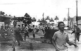 Fleeing an approaching tsunami in Hilo, Hawai'i | |
 | |
| UTC time | 1946-04-01 12:29:01 |
|---|---|
| ISC event | 898313 |
| USGS-ANSS | ComCat |
| Local date | 1 April 1946 |
| Local time | 03:29 |
| Magnitude | 8.6 Mw [1] |
| Depth | 15 km (9.3 mi) [1] |
| Epicenter | 53°29′N 162°50′W / 53.49°N 162.83°WCoordinates: 53°29′N 162°50′W / 53.49°N 162.83°W [1] |
| Areas affected |
Hawaii, Alaska United States |
| Max. intensity | VI (Strong) [1] |
| Tsunami | Yes |
| Casualties | 165–173 [2] |
The 1946 Aleutian Islands earthquake occurred near the Aleutian Islands, Alaska on April 1. The shock had a moment magnitude of 8.6 and a maximum Mercalli intensity of VI (Strong). It resulted in 165–173 casualties and over $26 million in damage. The seafloor along the fault was elevated, triggering a Pacific-wide tsunami with multiple destructive waves at heights ranging from 45–130 ft. The tsunami obliterated the Scotch Cap Lighthouse on Unimak Island, Alaska among others, and killed all five lighthouse keepers. Despite the destruction to the Aleutian Island Unimak, the tsunami had almost an imperceptible effect on the Alaskan mainland.[3]
Waves reportedly traveled across the ocean at 500 miles an hour and measured 55 feet high, crest to trough, according to the USGS. The wave reached Kauai, Hawaii 4.5 hours after the quake, and Hilo, Hawaii 4.9 hours later. In Hilo, the death toll was high: 173 were killed, 163 injured, 488 buildings were demolished and 936 more were damaged. Witnesses told of waves inundating streets, homes, and storefronts. Many victims were swept out to sea by receding water. The tsunami caused a lot of damage in Maui as well. Waves there demolished 77 homes and many other buildings. [4] The residents of these islands were caught completely off-guard by the onset of the tsunami due to the inability to transmit any warnings from the destroyed posts at Scotch Cap, and the tsunami is known as the April Fools Day Tsunami in Hawaii because it happened on April 1st and many people thought it to be an April Fool's Day prank. The effects of the tsunami also reached the West Coast of the United States.[3]
The tsunami was unusually powerful for the size of the earthquake. The event was classified as a tsunami earthquake due to the discrepancy between the size of the tsunami and the relatively low surface wave magnitude.[5] The large-scale destruction prompted the creation of the Seismic Sea Wave Warning System, which became the Pacific Tsunami Warning Center in 1949.[6]
See also
References
- 1 2 3 4 National Geophysical Data Center. "Comments for the Significant Earthquake". Retrieved 10 September 2011.
- ↑ USGS (September 4, 2009), PAGER-CAT Earthquake Catalog, Version 2008_06.1, United States Geological Survey
- 1 2 "1946 Aleutian Tsunami". www.usc.edu. Archived from the original on 2016-01-12. Retrieved 2016-02-02.
- ↑ https://www.civilbeat.org/2011/03/9558-a-history-of-tsunamis-in-hawaii/
- ↑ Kanamori, H. (1972). "Mechanism of tsunami earthquakes" (PDF). Physics of the Earth and Planetary Interiors. 6 (5): 346–359. Bibcode:1972PEPI....6..346K. doi:10.1016/0031-9201(72)90058-1.
- ↑ The April 1, 1946 Earthquake and Tsunami in the Aleutian Islands, George Pararas-Carayannis
External links
- Tsunami 1946 – Hilo on YouTube
- Tsunami Animation: Unimak Island, Aleutian Islands, 1946 – Pacific Tsunami Warning Center
- 1946 Aleutians Tsunami – Western States Seismic Policy Council
- Mystery of Deadly 1946 Tsunami Deepens – LiveScience
- The International Seismological Centre has a bibliography and/or authoritative data for this event.