1946 Dominican Republic earthquake
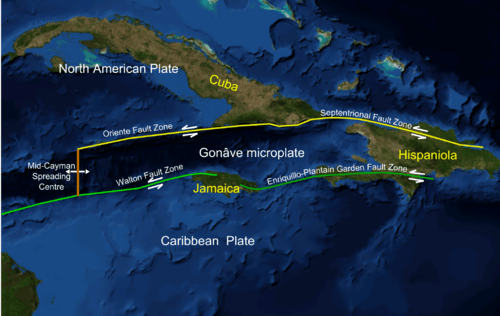 The Septentrional-Oriente fault zone in the Caribbean and across Hispaniola | |
 | |
| UTC time | 1946-08-04 17:51:10 |
|---|---|
| ISC event | 898498 |
| USGS-ANSS | ComCat |
| Local date | August 4, 1946 |
| Local time | 13:51 |
| Magnitude | 8.1 Ms[1] |
| Epicenter | 19°12′00″N 69°18′58″W / 19.2°N 69.316°WCoordinates: 19°12′00″N 69°18′58″W / 19.2°N 69.316°W |
| Areas affected | Dominican Republic |
| Max. intensity | IX (Violent) [2] |
| Peak acceleration | .4g (est) [2] |
| Tsunami | Yes |
| Casualties | 2,550 |
The 1946 Dominican Republic earthquake occurred on August 4 at 17:51 UTC near Samaná, Dominican Republic. The mainshock measured 8.1 on the surface wave magnitude scale and an aftershock occurred four days later on August 8 at 13.28 UTC with a magnitude of 7.6. A tsunami was generated by the initial earthquake and caused widespread devastation across Hispaniola. The tsunami was observed in much of the Caribbean and the southern Atlantic Ocean.
Damage
The earthquake killed around 100, but left some 20,000 people homeless. The death toll was unusually low as it coincided with a holiday in the afternoon, when most people were outdoors. It caused severe damage in the northern Dominican Republic from Samana to Santiago and Puerto Plata. Slumping and sand blows were observed in the Yaque del Norte and Yuna River Valleys. The earthquake was felt strongly in parts of Haiti and Puerto Rico, and to a lesser extent in the Virgin Islands and eastern Cuba.[3]
Tsunami
The earthquake also caused a tsunami which struck at Matanza, near Nagua (Julia Molina), where a 2.5–5-metre (8–16 ft) high wave drowned a number of people and affected an area of land several kilometres inland. The tsunami associated with the quake killed 1,600–1,800 people, for a total of about 2,550 fatalities.[4][5]
A small tsunami was also recorded by tide gauges at San Juan in Puerto Rico, Bermuda and in the United States at Daytona Beach, Florida and Atlantic City, New Jersey.[6]
See also
References
- ↑ Dolan, James F. (1998). Paul Mann, ed. Active Strike-Slip and Collisional Tectonics of the Northern Caribbean Plate Boundary Zone. Geological Society of America. p. 44. ISBN 978-0-8137-2326-6.
- 1 2 Lynch, Joseph J.; Bodle, Ralph R. (1948), "The Dominican earthquakes of August, 1946", Bulletin of the Seismological Society of America, 38 (1): 4, 5
- ↑ Historic Earthquakes: Samana, Dominican Republic 1946 Archived 2008-06-02 at the Wayback Machine., USGS, Retrieved June 10, 2008
- ↑ Woods Hole Oceanographic Institution (February 8, 2005). "Major Caribbean Earthquakes And Tsunamis A Real Risk". Science Daily. Retrieved December 9, 2012.
- ↑ O'Loughlin, Karen Fay; Lander, James F. (2003), Caribbean tsunamis: a 500-year history from 1498–1998, Boston: Kluwer, p. 82, ISBN 978-1-4020-1717-9
- ↑ Lander, James F.; Lockridge, Patricia A. (1989). United States Tsunamis, (including United States possessions) 1690–1988: Publication 41-2 (PDF). United States Department of Commerce. pp. 219, 220.
Further reading
- Small, Walter M. (1948), "A short description of the general geology of the Dominican Republic, with notes on the earthquake of August 4, 1946", Bulletin of the Seismological Society of America, 38 (1): 19–32
External links
- The International Seismological Centre has a bibliography and/or authoritative data for this event.