1886 Charleston earthquake
  | |
| Local date | August 31, 1886 |
|---|---|
| Local time | 21:50 |
| Magnitude | 6.9–7.3 Mw [1] |
| Epicenter | 32°54′N 80°00′W / 32.9°N 80.0°WCoordinates: 32°54′N 80°00′W / 32.9°N 80.0°W [2] |
| Type | Unknown |
| Areas affected |
South Carolina United States |
| Total damage | $5–6 million [2] |
| Max. intensity | X (Extreme) [2] |
| Casualties | 60 [2] |
The 1886 Charleston earthquake occurred about 9:50 p.m. local time August 31 with an estimated moment magnitude of 6.9–7.3 and a maximum Mercalli intensity of X (Extreme). The intraplate earthquake caused 60 deaths and between $5 million and $6 million in damage to 2,000 buildings in the Southeastern United States. It is one of the most powerful and damaging earthquakes to hit the East Coast of the United States. Very little to no historical earthquake activity had occurred, which is unusual for any seismic area.[3]
Earthquake

The shock was felt as far away as Boston, Massachusetts, to the north, Chicago, Illinois, and Milwaukee, Wisconsin, to the northwest, as far as New Orleans, Louisiana, to the west, as far as Cuba to the south, and as far as Bermuda to the east.[4] It was so severe that outside the immediate area, there was speculation that the Florida peninsula had broken away from North America.[5]
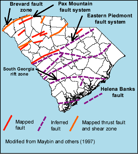
It is a heavily studied example of an intraplate earthquake and is believed to have occurred on faults formed during the break-up of Pangaea. Similar faults are found all along the east coast of North America. It is thought that such ancient faults remain active from forces exerted on them by present-day motions of the North American Plate. The exact mechanisms of intraplate earthquakes are a subject of much ongoing research.
Sand boils were common throughout the affected area due to soil liquefaction. Aftershocks continued to be felt for weeks after the event[5] and minor earthquake activity that still continues in the area today may be a continuation of aftershocks. There were at least 60 fatalities.
Damage
Within the city almost all of the buildings sustained damage and most had to be torn down and rebuilt. Wires were cut and the railroad tracks were torn apart, cutting residents off from the outside world and vice versa. The damage was assessed to be between $5 million and $6 million.
Major damage occurred as far away as Tybee Island, Georgia, (more than 60 miles away) and structural damage was reported several hundred miles from Charleston, (including central Alabama, central Ohio, eastern Kentucky, southern Virginia and western West Virginia).
The Old White Meeting House near Summerville, Dorchester County, South Carolina was reduced to ruins.[6]
Aftermath
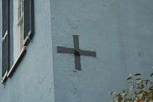
Earthquake bolts were added to existing unreinforced masonry buildings to add support to the structure without having to demolish the structure due to instability. The bolts pass through the existing masonry walls tying walls on opposite sides of the structure together for stability.
See also
References
- ↑ Chapman, M. C.; Beale, J. N.; Hardy, A. C.; Wu, Q. (2016), "Modern Seismicity and the Fault Responsible for the 1886 Charleston, South Carolina, Earthquake", Bulletin of the Seismological Society of America, Seismological Society of America, 106 (2): 364–372, Bibcode:2016BuSSA.106..364C, doi:10.1785/0120150221
- 1 2 3 4 Stover, C.W.; Coffman, J.L. (1993), Seismicity of the United States, 1568–1989 (Revised), U.S. Geological Survey Professional Paper 1527, United States Government Printing Office, pp. 348–351
- ↑ Bollinger, G. A. (1972), "Historical and recent seismic activity in South Carolina", Bulletin of the Seismological Society of America, Seismological Society of America, 62 (3): 851–864
- ↑ Charleston Quake, 1886, USGS, archived from the original on 2016-12-25, retrieved 2017-08-28
- 1 2 Pickney, Paul (1906), Lessions Learned from the Charleston Quake
- ↑ "Old White Meeting House Ruins and Cemetery, Dorchester County (SC Hwy 642, Summerville vicinity)". National Register Properties in South Carolina. South Carolina Department of Archives and History. Retrieved 5 July 2012.
Sources
- Talwani, P.; Cox, J. (1985), "Paleoseismic Evidence for Recurrence of Earthquakes near Charleston, South Carolina", Science, American Association for the Advancement of Science, 229 (4711): 379–381, Bibcode:1985Sci...229..379T, doi:10.1126/science.229.4711.379, PMID 17795896
- Tarr, A.C.; Talwani, P.; Rhea, S.; Carver, D.; Amick, D. (1981), "Results of recent South Carolina seismological studies", Bulletin of the Seismological Society of America, Seismological Society of America, 71 (6): 1883–1902
External links
- The Charleston Earthquake of 1886 – University of South Carolina
- Historical Earthquakes: Charleston, South Carolina – United States Geological Survey
- Fault Map of South Carolina – South Carolina Department of Natural Resources
- Waring Historical Library 1886 Charleston Earthquake Photo Collection – Lowcountry Digital Library
- Overview of an archival collection on the Charleston earthquake – Winterthur Museum, Garden and Library
- Charleston Earthquake, 1886 – University of South Carolina
- Isoseismal map of the earthquake centered near Charleston, South Carolina, on August 31, 1886 – University of California, Santa Cruz