1922 Atlantic hurricane season
| 1922 Atlantic hurricane season | |
|---|---|
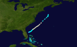
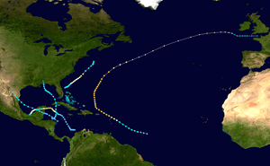 Season summary map | |
| Seasonal boundaries | |
| First system formed | May 12, 1922 |
| Last system dissipated | October 31, 1922 |
| Strongest storm | |
| Name | Two |
| • Maximum winds |
120 mph (195 km/h) (1-minute sustained) |
| • Lowest pressure | 960 mbar (hPa; 28.35 inHg) |
| Seasonal statistics | |
| Total storms | 5 |
| Hurricanes | 3 |
| Major hurricanes (Cat. 3+) | 1 |
| Total fatalities | Unknown |
| Total damage | Unknown |
|
| |
The 1922 Atlantic hurricane season ran through the summer and the first half of fall in 1922. The season was a quiet one, with only five tropical cyclones forming during the course of the season. The first was a tropical storm that passed over the Yucatán Peninsula and later made another landfall in rural northeast Mexico. The second was a hurricane, the strongest one of the season. It formed near Cape Verde and curved out into the Atlantic. It grazed the Leeward Islands and battered Bermuda, passing just offshore as a Category 3. The hurricane became extratropical soon after it passed Bermuda. The third was a tropical storm that passed over Cuba and made landfall near Pensacola, Florida. The last storm of the season was a Category 2 hurricane that made landfall near Cancún, Mexico. The hurricane weakened in the Bay of Campeche and dissipated just offshore. A fifth storm was found in reanalysis in 2009.
Systems
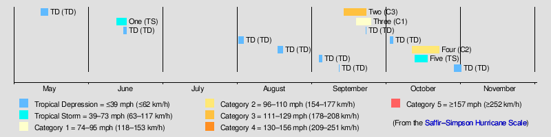
Tropical Storm One
| Tropical storm (SSHWS) | |
  | |
| Duration | June 12 – June 16 |
|---|---|
| Peak intensity | 50 mph (85 km/h) (1-min) 1003 mbar (hPa) |
Observations from ships indicate that a tropical disturbance developed into a tropical depression offshore Cabo Gracias a Dios, Nicaragua, on June 12.[1] The depression continued northwestward without significantly intensifying.[2] Heavy rainfall was reported in the Swan Islands of Honduras on June 12 and June 13.[1] Early on June 14, the depression made landfall in Mahahual, Quintana Roo, with winds of 35 mph (55 km/h). The cyclone entered the Gulf of Mexico late that day and began strengthening, reaching tropical storm status early on June 15.[2] Around 18:00 UTC, the storm peaked with maximum sustained winds of 50 mph (85 km/h) and a minimum barometric pressure of 1,003 mbar (29.6 inHg).[1] The system made landfall near La Pesca, Tamaulipas, at the same intensity early on June 16. After moving inland, the storm quickly weakened and dissipated by 18:00 UTC.[2]
The storm and its remnants brought heavy rainfall to Rio Grande valley, causing flooding. In Texas, the river at Eagle Pass reached 45.6 ft (13.9 m), 29.6 ft (9.0 m) above flood stage. Two bridges washed away, while businesses and homes were damaged. Further down the river, the swollen crest of the Rio Grande and San Juan rivers merged, causing significant flooding in Cameron and Hidalgo counties. Many towns in both county suffered severe damage. It was estimated that damage to crops alone reached about $2 million. On the Mexico side of the river, water inundated more than 30,000 acres of agricultural lands. Infrastructure such as roads, bridges, railroads, and buildings were damaged.[1]
Hurricane Two
| Category 3 hurricane (SSHWS) | |
 | |
| Duration | September 13 – September 22 |
|---|---|
| Peak intensity | 120 mph (195 km/h) (1-min) 960 mbar (hPa) |
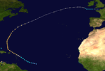
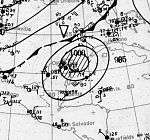
By far the most powerful storm of the season, this hurricane formed well east of the Windward Islands and moved northwestward steadily strengthening. It grazed the Leeward Islands as a Category 2 hurricane and began to recurve shortly thereafter. During this recurvature, it strengthened into a Category 3 storm, eventually attaining winds of 120 mph (190 km/h). It would maintain Category 3 intensity for the next four days until it became extratropical on September 23. The storm passed almost directly over Bermuda early on September 21, buffeting the island with 115 mph (185 km/h) winds and an eight-foot storm surge. As the center of this hurricane passed Bermuda to the southeast, a lull occurred on the island for an hour around 9 am on September 21. The lowest pressure measured was 968 mbar (28.57 inHg). Significant damage occurred there, as winds peaked at 120 mph (190 km/h). It was Bermuda's highest tide since the hurricane of 1899.[3]
Hurricane Three
| Category 1 hurricane (SSHWS) | |
  | |
| Duration | September 18 – September 24 |
|---|---|
| Peak intensity | 80 mph (130 km/h) (1-min) 987 mbar (hPa) |
A low pressure area developed into a tropical depression about 75 mi (120 km) east of Florida at 00:00 UTC on September 18. It is estimated that the depression reached tropical storm intensity about 12 hours later,[2] based on ships reporting near-tropical storm force winds.[1] The storm drifted northeast and slowly strengthened, becoming a hurricane on September 20. The system made have interacted with the previous storm, which was at Category 3 intensity and located near Bermuda on September 21. Intensifying slightly further, the hurricane peaked with maximum sustained winds of 80 mph (130 km/h) and a minimum barometric pressure of 987 mbar (29.1 inHg) at 12:00 UTC on September 22,[2] with both estimated using observations from a ship and the pressure-wind relationship.[1] However, by September 23, the cyclone weakened to a tropical storm. After briefly accelerating, the storm curved northward and drifted,[2] before being absorbed by an extratropical storm about 165 mi (265 km) southeast of Massachusetts by 00:00 UTC on September 25.[2][1] This hurricane was not considered a tropical cyclone until reanalysis in 2009. Tropical storm force winds were reported in Florida, North Carolina, and New Jersey.[1]
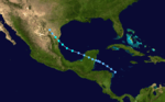
Hurricane Four
| Category 2 hurricane (SSHWS) | |
  | |
| Duration | October 11 – October 22 |
|---|---|
| Peak intensity | 110 mph (175 km/h) (1-min) <984 mbar (hPa) |
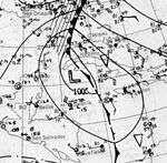
Early on October 12, a low-pressure area was detected by the S.S. Chalmette in the western Caribbean,[4] and the system is believed to have organized to a minimal tropical storm 260 miles (420 km) southwest of Kingston, Jamaica late on October 13.[5] The cyclone slowly moved northwest, and it gradually intensified on October 15. On the evening of October 16, the tropical storm rapidly intensified, and it strengthened to the equivalent of a category 2 hurricane on October 17. Later, it attained peak sustained winds of 110 mph (175 km/h).[5] Early on October 18, a ship reported a minimum pressure of 984 mbar (29.06 inHg) near the center, which was the lowest pressure measured during the life span of the storm.[4] Subsequently, the hurricane weakened, and it made landfall 10 miles (16 km) south of Cancún with winds of 80 mph (130 km/h).[5] It crossed the peninsula and moved south along the coast, weakening to a minimal tropical storm and striking the Tabasco area. The storm caused significant property damage and shipping losses. Several fishing vessels sank and some ocean liners (including the now-infamous Morro Castle) were stranded outside Vera Cruz harbor because violent seas made it too dangerous to enter. There were a few fatalities in the Yucatán, where damage to buildings and crops was severe.
Tropical Storm Five
| Tropical storm (SSHWS) | |
  | |
| Duration | October 12 – October 17 |
|---|---|
| Peak intensity | 50 mph (85 km/h) (1-min) <1000 mbar (hPa) |
Storm Five formed of the northern coast of Honduras on October 12 and turned northwestward. The storm strengthened very little during its lifetime, striking western Cuba with only 45 mph (72 km/h) sustained winds. It reached its peak intensity of 50 mph (80 km/h) in the Gulf of Mexico. It held this intensity for two days, weakening just before landfall near Orange Beach, Alabama. The storm dissipated quickly inland. It may have been a subtropical storm due to some hybrid characteristics.[5]
See also
References
- 1 2 3 4 5 6 7 8 Christopher W. Landsea; et al. Documentation of Atlantic Tropical Cyclones Changes in HURDAT. Atlantic Oceanographic and Meteorological Laboratory (Report). Miami, Florida: National Oceanic and Atmospheric Administration. Retrieved September 21, 2016.
- 1 2 3 4 5 6 7 "Atlantic hurricane best track (HURDAT version 2)". Hurricane Research Division (Database). National Hurricane Center. May 1, 2018. Retrieved October 2, 2018.
- ↑ Tucker, Terry (1966). Beware the Hurricane! Hamilton Press.
- 1 2 "1922 Monthly Weather Review" (PDF). U.S. Weather Bureau. Retrieved 2008-04-28.
- 1 2 3 4 Hurricane Research Division (2008). "Atlantic hurricane best track". NOAA. Retrieved 2008-04-06.
Printed media
- Terry Tucker. Beware the Hurricane! Hamilton Press: Bermuda, 1966.
External links
| Wikimedia Commons has media related to 1922 Atlantic hurricane season. |