1921 Atlantic hurricane season
| 1921 Atlantic hurricane season | |
|---|---|
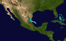
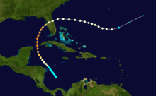
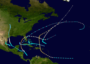 Season summary map | |
| Seasonal boundaries | |
| First system formed | June 1, 1921 |
| Last system dissipated | November 25, 1921 |
| Strongest storm | |
| Name | Six |
| • Maximum winds |
140 mph (220 km/h) (1-minute sustained) |
| • Lowest pressure | 941 mbar (hPa; 27.79 inHg) |
| Seasonal statistics | |
| Total storms | 7 |
| Hurricanes | 5 |
| Major hurricanes (Cat. 3+) | 2 |
| Total fatalities | 306 |
| Total damage | $3 million (1921 USD) |
|
| |
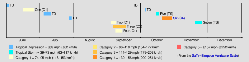
The 1921 Atlantic hurricane season ran through the summer and the first half of fall in 1921. The season was near average, with seven tropical cyclones forming during the season.
Timeline
Systems
Hurricane One
| Category 1 hurricane (SSHWS) | |
 | |
| Duration | June 16 – June 26 |
|---|---|
| Peak intensity | 90 mph (150 km/h) (1-min) 980 mbar (hPa) |
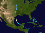
A tropical storm formed in the western Caribbean before moving across the Yucatan peninsula into the southern Gulf of Mexico. The storm recurved towards the north, strengthening into a category 1 hurricane before it struck Sargent, Texas. During the night of June 21, winds increased to 68 miles per hour (109 km/h) at Corpus Christi, Texas. A barge with 18,000 gallons of oil sank in Port Aransas, Texas. A storm surge of 7.1 feet (2.2 m) was measured at Pass Cavallo. As the cyclone moved inland, it passed directly over Palacios, Texas, Wharton, Texas, and Wallis, Texas. Winds gusted to 60 miles per hour (97 km/h) at both Galveston, Texas and Houston, Texas. Heavy rains accompanied the system, with 10.10 inches (257 mm) recorded at Matagorda, Texas.[1]
Hurricane Two
| Category 1 hurricane (SSHWS) | |
  | |
| Duration | September 4 – September 8 |
|---|---|
| Peak intensity | 80 mph (130 km/h) (1-min) 985 mbar (hPa) |
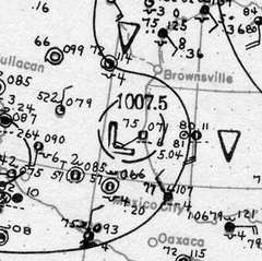
An area of disturbed weather developed into a tropical depression over the Bay of Campeche on September 4.[2] The depression moved slowly northwestward and reached tropical storm intensity by 00:00 UTC on September 6. The storm then curved west-northwestward and reached hurricane intensity about twenty four hours. Around that time,[3] the system peaked with maximum sustained winds of 80 mph (130 km/h) and an estimated minimum barometric pressure of 985 mbar (29.1 inHg). At 03:00 UTC on September 7, the hurricane made landfall in Mexico just north of Tampico, Tamaulipas.[2] After moving inland, the storm weakened and dissipated early on September 8.[3]
After the cyclone dissipated on September 8, an extremely heavy rainfall event ensued across central Texas, which continued into September 11. In Williamson County, a new 18-hour rainfall record was set for the United States as 36.40 in (925 mm) was recorded at Thrall;[4] the storm total rainfall there was 39.71 in (1,009 mm).[5] The deluge led to one of the most destructive floods in the history of San Antonio. Water rose to 7 ft (2.1 m) deep in the city, forcing people to evacuate vertically within taller buildings. The most significant river floods occurred on the Little and San Gabriel rivers, where 159 people perished. Combined with the death toll from elsewhere across the region, 215 people died due to this storm and damages were estimated at $19 million.[1]
Hurricane Three
| Category 3 hurricane (SSHWS) | |
 | |
| Duration | September 6 – September 17 |
|---|---|
| Peak intensity | 125 mph (205 km/h) (1-min) 961 mbar (hPa) |
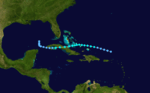
Hurricane San Pedro of 1921
A tropical storm was first observed about 500 mi (800 km) east of the island of Trinidad on September 6. It moved nearly due westward and struck the Windward Islands on September 8 as a Category 1 hurricane. The storm moved northwestward across the Caribbean and intensified into a major hurricane on September 9. Thereafter, the cyclone began to curve northward, and early on September 11, it made landfall in Dominican Republic near Boca de Yuma at peak intensity as a Category 3 hurricane with winds of 125 mph (205 km/h). The storm weakened to a Category 2 hurricane after striking the island, but re-strengthened into a Category 3 while northeast of the Bahamas on September 13. The storm curved northeastward on September 14 and began accelerated. On the following day, the system weakened to a Category 2 hurricane near Bermuda. Early on September 17, the system weakened to a Category 1 hurricane and soon transitioned into an extratropical cyclone about 310 mi (500 km) east of Newfoundland.[3] The remnants were absorbed by a larger extratropical storm later on September 17.[2]
On Grenada, a number of homes were destroyed, while several other buildings suffered damage. The storm severely damaged nutmeg and cocoa crops, the latter of which was estimated to require at least seven years to be re-established. Telephone communications in rural areas was lost. At least two deaths occurred on the island. On Saint Vincent, trees and telegraph and telephone lines were downed. Extensive crop and property damage was reported,[2] with thousands of people left homeless.[6] Strong winds on Trinidad disrupted telegraphic communications. A number of lights and small craft at Port of Spain and San Fernando were sunk or washed ashore. Two fatalities occurred on the island, one from drowning and the other from electrocution. Throughout the Windward Islands, 80 deaths were reported. The storm caused extensive damage to buildings in Puerto Rico and Bermuda,[2] with one fatality in the former.[7]
Hurricane Four
| Category 1 hurricane (SSHWS) | |
 | |
| Duration | September 8 – September 14 |
|---|---|
| Peak intensity | 90 mph (150 km/h) (1-min) 979 mbar (hPa) |
A low pressure area of non-tropical origins became a tropical storm on September 8 while situated about 300 mi (480 km) north of the Lesser Antilles.[2][3] The storm moved slowly west-northwestward over the next few days with little change in intensity. By September 10, the cyclone curved north-northeastward, sped-up, and began to strengthen. Late on September 11, the storm reached hurricane status. While passing east of Bermuda on the following day, the system peaked with maximum sustained winds of 90 mph (150 km/h). The hurricane accelerated after bypassing the island due to an approaching cold front.[3] A ship observed a barometric pressure of 979 mbar (28.9 inHg) around 09:00 UTC on September 14,[2] the lowest known pressure in relation to the storm.[3] However, by three hours later, the hurricane transitioned into an extratropical cyclone about 400 mi (640 km) southeast of Newfoundland. The extratropical storm was absorbed by a larger extratropical cyclone late on September 14.[2]
Tropical Storm Five
| Tropical storm (SSHWS) | |
 | |
| Duration | October 15 – October 17 |
|---|---|
| Peak intensity | 70 mph (110 km/h) (1-min) <998 mbar (hPa) |
A low pressure area developed into a tropical depression about 80 mi (130 km) southwest of the Florida Keys at 12:00 UTC on October 15.[2][3] The depression moved rapidly north-northeastward and made landfall near Cape Coral, Florida, several hours later. Shortly after emerging into the Atlantic near Cape Canaveral early on October 16, the cyclone intensified into a tropical storm.[3] Around 12:00 UTC on October 17, the system peaked with maximum sustained winds of 70 mph (110 km/h) and a minimum barometric pressure of 998 mbar (29.5 inHg), both were observations by a ship.[2] By 00:00 UTC on the following day, the storm transitioned into an extratropical cyclone about 310 mi (500 km) south of Sable Island. The remnants continued eastward across the Atlantic and intensified into the equivalence of a Category 1 hurricane while approaching the Azores. The extratropical cyclone then moved in a semi-circulation path before dissipating southwest of the islands early on October 24.[3]
Hurricane Six
| Category 4 hurricane (SSHWS) | |
 | |
| Duration | October 20 – October 29 |
|---|---|
| Peak intensity | 140 mph (220 km/h) (1-min) 941 mbar (hPa) |
The Great Tampa Bay Hurricane of 1921
A tropical storm developed from a trough in the southwestern Caribbean Sea on October 20.[2] The system moved northwestward and intensified into a hurricane on October 22 and a major hurricane by October 23. Later that day, the cyclone peaked as a Category 4 with winds of 140 mph (220 km/h). After entering the Gulf of Mexico, the hurricane gradually curved northeastward and weakened to a Category 3 before making landfall near Tarpon Springs, Florida, late on October 25. The storm quickly weakened to a Category 1 hurricane while crossing Central Florida, before reaching the Atlantic Ocean early on the following day. Thereafter, system moved east-southeastward and remained fairly steady in intensity before weakening to a tropical storm late on October 29.[3] The storm was then absorbed by a larger extratropical cyclone early the next day, with the remnants of the hurricane soon becoming indistinguishable.[2]
The storm brought strong winds to the Swan Islands, including hurricane-force winds on the main island.[2] Heavy rains fell in Cuba, particularly in Pinar del Río Province, but only minor damage occurred.[8] In Florida, storm surge and abnormally high tides caused damage along much of the state's west coast from Pasco County southward. Several neighborhoods and sections of Tampa were inundated, especially in Ballast Point, DeSoto Park, Edgewater Park, Hyde Park, Palmetto Beach, and other areas in the vicinity of Bayshore Boulevard.[9] Strong winds also damaged hundreds of trees, signs, buildings, and homes.[10] Five deaths occurred in Tampa, two from drowning and three after people came into contact with a live wire. The storm left two additional fatalities in St. Petersburg.[9] A number of streets in Tarpon Springs were littered with masses of debris,[11] with many structures and trees suffering extensive damage.[12] Strong winds occurred as far east as the Atlantic coast of the state, though wind damage east of the Tampa Bay area was generally limited to downed trees and power lines, resulting in power outages, particularly in Orlando.[13] Agriculture throughout the state experienced significant impact as well, including over $2 million in damage and the loss of at least 800,000 boxes of citrus crops alone.[14] Overall, the hurricane left at least eight deaths and about $10 million in damage.[9][15]
Tropical Storm Seven
| Tropical storm (SSHWS) | |
 | |
| Duration | November 19 – November 25 |
|---|---|
| Peak intensity | 60 mph (95 km/h) (1-min) <1003 mbar (hPa) |
Tropical Storm Seven formed on November 19. It made landfall in Cuba before dissipating on November 25.
See also
References
- 1 2 David M. Roth (2010-01-17). "Texas Hurricane History" (PDF). Hydrometeorological Prediction Center. pp. 39–40. Archived (PDF) from the original on 28 May 2010. Retrieved 2010-04-26.
- 1 2 3 4 5 6 7 8 9 10 11 12 13 Christopher W. Landsea; et al. (December 2012). Documentation of Atlantic Tropical Cyclones Changes in HURDAT. Atlantic Oceanographic and Meteorological Laboratory (Report). Miami, Florida: National Oceanic and Atmospheric Administration. Retrieved July 9, 2017.
- 1 2 3 4 5 6 7 8 9 10 "Atlantic hurricane best track (HURDAT version 2)". Hurricane Research Division (Database). National Hurricane Center. May 1, 2018. Retrieved October 2, 2018.
- ↑ J. L. H. Paulhaus (1973). World Meteorological Organization Operational Hydrology Report No. 1: Manual For Estimation of Probable Maximum Precipitation. World Meteorological Organization. p. 178.
- ↑ R. W. Schoner and S. Molansky (July 1956). National Hurricane Research Project No. 3: Rainfall Associated With Hurricanes (and Other Tropical Disturbances) (PDF). United States Department of Commerce. p. 4. Retrieved July 29, 2017.
- ↑ "Thousands homeless following hurricane". Hartford Courant. September 13, 1921. p. 17 – via Newspapers.com.

- ↑ Orlando Férez (1970). Notes on the Tropical Cyclones of Puerto Rico (PDF) (Report). National Weather Service San Juan, Puerto Rico. p. 25. Retrieved September 3, 2017.
- ↑ "Tropical Storm Moves Into Gulf of Mexico". Havana, Cuba: The Palm Beach Post. October 25, 1921. p. 1. Retrieved September 1, 2016 – via Newspapers.com.
- 1 2 3 Jay Barnes (2007). Florida's Hurricane History. University of North Carolina Press. p. 104. ISBN 978-0-8078-3068-0. Retrieved July 8, 2017.
- ↑ "Tampa is Hard Hit by Storm; Three Die During Heavy Gale". St. Petersburg Times. Tampa, Florida. October 27, 1921. p. 2. Retrieved July 9, 2017.
- ↑ "Sponge City Is Hit Hard". St. Petersburg Times. October 28, 1921. p. 2. Retrieved March 21, 2017.
- ↑ "Five Millions Damage by Storm". The Palm Beach Post. Lakeland, Florida. October 28, 1921. p. 6. Retrieved February 23, 2017 – via Newspapers.com.
- ↑ "Sea, Piled Up by Gale, Floods Tampa; Damage $1,000,000". New-York Tribune. Jacksonville, Florida. October 26, 1921. p. 1. Retrieved March 1, 2017 – via Newspapers.com.
- ↑ Edward H. Bowie (October 1921). "The Hurricane of October 25, 1921, at Tampa, Fla" (PDF). Monthly Weather Review. Washington, D.C.: United States Weather Bureau. 49 (10): 567, 568, and 570. Bibcode:1921MWRv...49..567B. doi:10.1175/1520-0493(1921)49<567:THOOAT>2.0.CO;2. Retrieved July 9, 2017.
- ↑ Jeff Masters (July 26, 2016). "Extreme 'Grey Swan' Hurricanes in Tampa Bay: a Potential Future Catastrophe". Weather Underground. Retrieved July 7, 2017.
External links
| Wikimedia Commons has media related to 1921 Atlantic hurricane season. |