Anah
| Anah عانة | |
|---|---|
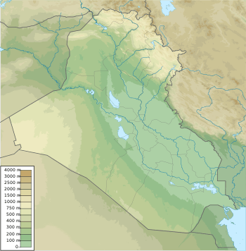 Anah Location within Iraq | |
| Coordinates: 34°22′20″N 41°59′15″E / 34.37222°N 41.98750°ECoordinates: 34°22′20″N 41°59′15″E / 34.37222°N 41.98750°E | |
| Country |
|
| Province | Al-Anbar |
| Government | |
| • Mayor | Saad Awwad |
| Elevation | 34 m (112 ft) |
| Population (2013)[1] | |
| • Total | 27,211 |
| Time zone | UTC+3 (GMT+3) |
| Postal code | 31005 |
Anah or Ana (Arabic: عانة, ʾĀna), formerly also known as Anna,[2] is an Iraqi town on the Euphrates river, approximately midway between the Gulf of Alexandretta and the Persian Gulf. Anah lies from west to east on the right bank along a bend of the river just before it turns south towards Hit.
Name
The town is called Ha-na-atK1 in a Babylonian letter around 2200 BC,[3] A-na-at by the scribes of Tukulti-Ninurta c. 885 BC, and An-at by the scribes of Assur-nasir-pal II in 879 BC.[3] The name has been connected with the widely worshipped war goddess Anat.[3] It was known as Anathō (Greek: Άναθω) to Isidore Charax and Anatha to Ammianus Marcellinus; early Arabic writers described it variously as ʾĀna or (as if plural) ʾĀnāt.[3]
History
Ancient
Despite maintaining its name across 42 centuries, the exact location of the settlement seems to have moved from time to time. Sources across most of its early history, however, place Anah on an island in the Euphrates.[n 1]
Its early history under the Babylonians is uncertain. A 3rd-millennium BC letter mentions six "men of Hanat" are mentioned in a description of disturbances in the Residency of Suhi, which would have included the district of Anah.[3] It is probably not the place mentioned by Amenhotep I in the 16th century BC or in the speech of Sennacherib's messengers to Hezekiah,[4][5] but probably was the site "in the middle of the Euphrates" opposite which Assur-nasir-pal II halted during his 879 BC campaign.[3] It may also be mentioned in four 7th-century BC documents edited by Claude Hermann Walter Johns.[6][n 2]
Xenophon records that the army of Cyrus resupplied during a campaign in 401 BC at "Charmande" near the end of a 90-parasang march between Korsote and Pylae,[7] which likely intends Anah. It was the site where Julian first met opposition in his AD 363 expedition against Parthia. He got possession of the place and relocated its inhabitants.[3]
Medieval

In 657, during the Muslim conquest of Iraq, Ali's lieutenants Ziyad and Shureih were refused passage across the Euphrates at Anah.[8] Later, in 1058, Anah was the place of exile of the caliph Qaim when al-Basasiri was in power.[3][9] In the 14th century, Anah was the seat of the catholicos who served as primate over the Persian Christians.[3] Throughout early Islamic rule, it was a prosperous trade town, well known for its date palms and gardens;[9] in the 14th century, Mustafi wrote of the fame of its palm groves. Medieval Arab poets celebrated Anah's wine;[9][10]
Between the 14th and 17th centuries, Anah served as a headquarters for a host of regional Arab tribes.[9] In 1574, Leonhart Rauwolff found the town divided into two parts, the Turkish "so surrounded by the river that you cannot go into it but by boats" and the larger Arabian section along one of the banks. In 1610, Texeira said Anah lay on both banks of the river, with which Pietro Della Valle agreed.[11] In that year, Della Valle found the Scot George Strachan resident at Anah, working as the physician to the emir and studying Arabic;[12] he also found some sun worshipers still living there. Della Valle and Texeira called Anah the principal Arab town on the Euphrates, controlling a major route west from Baghdad and territory reaching Palmyra.[3]
Late Ottoman era
About 1750, the Ottomans installed a rudimentary administration to run Anah and its district.[9] After roughly a century, a more organized local government was put in place, whereby Anah became the center of a kaza belonging to the Baghdad Vilayet.[9]
At the beginning of the 19th century, G.A. Olivier found only 25 men in service of the local prince, with residents fleeing daily to escape from bedouin attacks against which he offered no protection.[13] He described the city as a single long street of five or six miles along a narrow strip of land between the river and a ridge of rocky hills.[14] W. F. Ainsworth, chronicling the British Euphrates expedition, reported that in 1835 the Arabs inhabited the northwest part of the town, the Christians the center, and the Jews the southeast.[15] The same year, the steamer Tigris went down in a storm just above Anah, near where Julian's force had suffered from a similar storm.[3]
By the mid-19th century, the houses were separated from one another by fruit gardens, which also filled the riverine islands near the town.[2] The most easterly island contained a ruined castle, while the ruins of ancient Anatho extended a further 2 miles along the left bank.[2] It marked the boundary between the olive (north) and date (south) growing regions in the area.[3] With the positioning of Turkish troops in the town around 1890, the locals no longer had to pay blackmail (huwwa) to the bedouins.[16] Through the early 20th century, coarse cotton cloth was the only manufacture.[2][3] In 1909 Anah had an estimated population of 15,000 and 2,000 houses.[17] Most of the inhabitants were Sunni Muslim Arabs, though a small Jewish community lived in the town's southern edge.[17]
Kingdom of Iraq
In 1918, the town was captured by British forces and by 1921, became incorporated into the Kingdom of Iraq.[9] It remained an administrative center of a qadaa, part of the larger Ramadi-based liwa of Dulaym. Anah's qadaa also included the subdistricts of Hīt, al-Qa'im and Jubba.[9] The townspeople's long feud with the inhabitants of Rawa was settled diplomatically by 1921.[9] Its territory to the west was dominated by the subtribes of Anizzah, while to the east the Jarba branch of the Shammar held sway.[9]
Most of Anah's building were located among a dense belt of date palms and was "reckoned as healthy and picturesque", according to historian S. H. Longrigg.[9] The date palms were irrigated by water wheels.[9] There were also more scattered dwelling in the mid-stream islands of the Euphrates near the town center.[9] The women of the town were well known for their beauty and the weaving of cotton and wool textiles.[9] The men, many of whom were compelled to emigrate to lack of living space, were largely engaged as boatmen and transporters of water to Baghdad. The town had relatively high educational standards, with eight schools built there by 1946.[9]
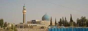
F. R. Chesney reported about 1800 houses, 2 mosques, and 16 waterwheels. One minaret is particularly old. Northedge reported the locals commonly attributed it to the 11th century but opined that it was more likely from about a century after that. It rose from one of the islands and belonged to the local mosque. Dr. Muayad Said described it as an octagonal body "enhanced by alcoves, some of which are blind" and noted earlier conservation work undertaken in 1935, 1963 and 1964. When the valley was flooded by the Haditha Dam in 1984 and '85, the Iraqi State Board of Antiquities cut it into sections and removed it to the new Anah, where it was re-erected to a height of 28 meters (92 ft) at the end of the 1980s.
ISIS captured the town in 2014.[18] On September 19, 2017, an offensive to retake the town from ISIS control began.[19]. After two days of fighting the town was recaptured by the Iraqi army.[20]
Climate
In Anah, there is a desert climate. Most rain falls in the winter. The Köppen-Geiger climate classification is BWh. The average annual temperature in Anah is 20.7 °C (69.3 °F). About 127 mm (5.00 in) of precipitation falls annually.
| Climate data for Anah | |||||||||||||
|---|---|---|---|---|---|---|---|---|---|---|---|---|---|
| Month | Jan | Feb | Mar | Apr | May | Jun | Jul | Aug | Sep | Oct | Nov | Dec | Year |
| Average high °C (°F) | 12.7 (54.9) |
16.1 (61) |
21.5 (70.7) |
27.0 (80.6) |
34.1 (93.4) |
38.5 (101.3) |
41.2 (106.2) |
41.0 (105.8) |
37.9 (100.2) |
31.7 (89.1) |
22.1 (71.8) |
14.1 (57.4) |
28.2 (82.7) |
| Average low °C (°F) | 3.3 (37.9) |
4.6 (40.3) |
7.8 (46) |
12.6 (54.7) |
17.8 (64) |
21.8 (71.2) |
24.4 (75.9) |
23.5 (74.3) |
19.6 (67.3) |
14.7 (58.5) |
7.3 (45.1) |
3.2 (37.8) |
13.4 (56.1) |
| Average precipitation mm (inches) | 21 (0.83) |
18 (0.71) |
19 (0.75) |
21 (0.83) |
5 (0.2) |
0 (0) |
0 (0) |
0 (0) |
0 (0) |
6 (0.24) |
13 (0.51) |
24 (0.94) |
127 (5) |
| Source: climate-data | |||||||||||||
Notes
- ↑ Viz., Tukulti-Ninurta II, Ashur-nasir-pal II, Isidore, Ammianus, Ibn Serapion, al-Istakri, Abulfeda, and al-Karamani.[3]
- ↑ The characters used are DIS TU, which may mean Ana-tu.[3]
- ↑ http://www.iraqcoalition.org/regions/south-central/provinces/english/anbar.html
- 1 2 3 4 EB (1878).
- 1 2 3 4 5 6 7 8 9 10 11 12 13 14 15 Hogg (1911).
- ↑ 2 Kings xix. 13
- ↑ Is. xxxvii. 13
- ↑ Ass. Deeds and Doc. nos. 23, 168, 228, 385.
- ↑ Xenophon, Anabasis.
- ↑ Tabari I. 3261.
- 1 2 3 4 5 6 7 8 9 10 11 12 13 14 15 Longrigg, p. 461.
- ↑ Yaqut, iii. 593f.
- ↑ Della Valle, i. 671.
- ↑ Della Valle, i. 671-681.
- ↑ Olivier (1807).
- ↑ Olivier (1807), p. 451.
- ↑ Ainsworth (1888).
- ↑ Von Oppenheim, 1893.
- 1 2 A Handbook of Mesopotamia, Volume III: Central Mesopotamia with Southern Kurdistan and the Syrian Desert. Admirality and War Office, Division of Intelligence. January 1917. pp. 351–352.
- ↑ Alissa J. Rubin (22 June 2014). Sunni Militants Capture Iraq’s Last Major Border Post With Syria The New York Times
- ↑ "Iraq 'attacks IS bastion on Syria border'". BBC News. 2017-09-19. Retrieved 2017-10-17.
- ↑ "Iraq: the town of Anah in western Anbar has been completely cleared by the ISF, next town is Rawa, after that al-Qaim and then the border - News from war on ISIS in English from Iraq, Syria - Deir ez-Zur operation, Raqqa operation - isis.liveuamap.com". News from war on ISIS in English from Iraq, Syria - Deir ez-Zur operation, Raqqa operation - isis.liveuamap.com. Retrieved 2017-10-17.
References

- Ainsworth, W.H. (1888), Euphrates Expedition
- Longrigg, S. H. (1960). "ʿĀna". The Encyclopedia of Islam, New Edition, Volume I: A–B. Leiden and New York: BRILL. p. 461. ISBN 90-04-08114-3.
- Olivier, G.A. (1807), Voyage dans l'empire othoman, Vol. III (in French)
Attribution:
External links
| Wikimedia Commons has media related to Anah. |
ب