Målselvdalen
| Målselvdalen | |
|---|---|
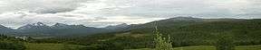 View of Målselva valley | |
 Målselvdalen Location of the valley  Målselvdalen Målselvdalen (Norway) | |
| Location | Troms, Norway |
| Long-axis length | 60 km (37 mi) |
| Width | 10 km (6.2 mi) |
| Geology | |
| Type | River valley |
| Geography | |
| Coordinates | 69°03′52″N 18°30′54″E / 69.0645°N 18.5151°ECoordinates: 69°03′52″N 18°30′54″E / 69.0645°N 18.5151°E |
| Population centers | Bardufoss, Andselv, Skjold |
Målselvdalen is the largest valley in Troms county, Norway. The river Målselva runs through the valley, ending at the Målselvfjorden (an arm off the main Malangen fjord). The 60-kilometre (37 mi) long valley runs to the north, along with the river, and most of the residents of Målselv Municipality live in this valley.
With a landscape reminiscent of that of the Østerdalen valley, the valley was settled in the late eighteenth century by farmers from the Østerdalen and Gudbrandsdalen valleys to the south. The bailiff in the district, Jens Holmboe, was instrumental in settling this region.[1]
References
- ↑ Store norske leksikon. "Målselvdalen" (in Norwegian). Retrieved 2010-04-09.
This article is issued from
Wikipedia.
The text is licensed under Creative Commons - Attribution - Sharealike.
Additional terms may apply for the media files.