Salyan (district in Nepal)
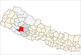
Salyan (Nepalees: सल्यान) is een van de 75 districten van Nepal. Het district is gelegen in de Rapti-zone en de hoofdplaats is Salyan Khalanga (of: Khalanga).
District in Nepal | |||
 | |||
| Situering | |||
| Regio | Mid Western (MWDR) | ||
| Zone | Rapti | ||
| Coördinaten | 28°22'0,01"NB, 82°10'0,01"OL | ||
| Algemeen | |||
| Oppervlakte | 1462 km² | ||
| Inwoners (2011) | 242.444[1] (166 inw./km²) | ||
| Hoofdstad | Salyan Khalanga | ||
| |||
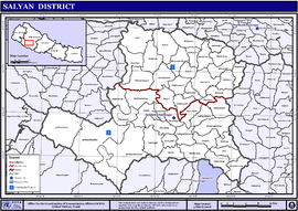
Steden en Dorpscommissies[2][3]
- Stad: Nepalees: nagarpalika of N.P.; Engels: municipality;
- Dorpscommissie: Nepalees: panchayat; Engels: village development committee of VDC.
- Steden (0): geen.
- Dorpscommissies (47): Badagaun (Salyan-district), Bafukhola, Bajh Kanda, Bame, Bhalchaur, Chande, Chhyachhetra, Damachaur, Damakot (of: Darmakot), Dandagaun (Salyan-district), Devsthan (of: Devsthal), Dhajari Pipal, Dhakadam, Dhanwang, Hiwalcha, Jimali, Kabheechaur (of: Kabhrechaur), Kajeri, Kalagaun, Kalimati Kalche, Kalimati Rampur, Karagithi, Kavra, Salyan Khalanga (Salyan-district) (of: Khalanga), Korbanglhimpc (of: Korbang Jhimpe), Kothara (of: Kotbara), Kotmula (of: Kotmala), Kubhinde Daha (of: Kupinde Daha), Laxmipur (Salyan-district), Lekhpokhara, Majhkanda (of: Majh Kanda), Marke, Marmaparikanda, Mulkhola, Nigalchula, Phalawang, Pipalneta (of: Pipal Neta), Rim, Saijuwal Takura, Sarpani Garpa, Sibartha (of: Sibaratha), Siddheswor (of: Siddheswar), Singwang (of: Sinwang), Suikot, Syanikhal, Tharmarre (of: Tharmare), Tribeni (Salyan-district).
Bronnen, noten en/of referenties
|
| Districten van Nepal | |
|---|---|
|
Achham · Arghakhanchi · Baglung · Baitadi · Bajhang · Bajura · Banke · Bara · Bardiya · Bhaktapur · Bhojpur · Chitwan · Dadeldhura · Dailekh · Dang · Darchula · Dhading · Dhankuta · Dhanusa · Dolkha · Dolpa · Doti · Gorkha · Gulmi · Humla · Ilam · Jajarkot · Jhapa · Jumla · Kailali · Kalikot · Kanchanpur · Kapilvastu · Kaski · Kathmandu · Kavrepalanchok · Khotang · Lalitpur · Lamjung · Mahottari · Makwanpur · Manang · Morang · Mugu · Mustang · Myagdi · Nawalparasi · Nuwakot · Okhaldhunga · Palpa · Panchthar · Parbat · Parsa · Pyuthan · Ramechhap · Rasuwa · Rautahat · Rolpa · Rukum · Rupandehi · Salyan · Sankhuwasabha · Saptari · Sarlahi · Sindhuli · Sindhulpalchok · Siraha · Solukhumbu · Sunsari · Surkhet · Syangja · Tanahu · Taplejung · Terhathum · Udayapur | |
Geplaatst op: 23-11-2009 |
Dit artikel is een beginnetje over landen & volken. U wordt uitgenodigd om op bewerken te klikken om uw kennis aan dit artikel toe te voegen. |