Rolpa (district)
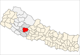
Rolpa (Nepalees: रोल्पा) is een van de 75 districten van Nepal. Het district is gelegen in de Rapti-zone en de hoofdplaats is Liwang.
District in Nepal | |||
 | |||
| Situering | |||
| Regio | Mid Western (MWDR) | ||
| Zone | Rapti | ||
| Coördinaten | 28°22'NB, 82°33'OL | ||
| Algemeen | |||
| Oppervlakte | 1879 km² | ||
| Inwoners (2011) | 224.506[1] (119 inw./km²) | ||
| Hoofdstad | Liwang | ||
| |||
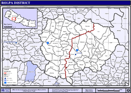
Steden en Dorpscommissies[2][3]
- Stad: Nepalees: nagarpalika of N.P.; Engels: municipality;
- Dorpscommissie: Nepalees: panchayat; Engels: village development committee of VDC.
- Steden (0): geen.
- Dorpscommissies (51): Aresh, Bhawang (of: Bhabang), Bhirul (of: Mirul), Budagaun, Dhawang, Dubaring (of: Dubring), Dubidanda, Eriwang, Fagaam, Gaam, Gairigaun, Gajul, Gharti Gaun, Ghodagaun, Gumchal, Harjang, Jailwang, Jaimakasala, Jankot (of: Jangkot), Jauli Pokharai (of: Jaulipokhari), Jedwang, Jhenam, Jinawang (of: Jinabang), Jungar, Kareti, Khumel, Khungri, Korchawang (of: Korchabang), Kotgaun, Kureli, Liwang (Rolpa (district), Masina (Rolpa (district), Mijhing, Nuwagaun, Pachhawang (of: Pachhabang), Pakhapani (Rolpa (district), Pang (Rolpa (district), Rangkot, Rangsi (Rolpa (district), Rank, Sakhi, Seram, Sirpa, Siuri, Talawang (of: Talabang), Tewang, Thawang (of: Thabang), Uwa, Wadachaur (of: Badachaur), Whama, Wot.
Bronnen, noten en/of referenties
|
| Districten van Nepal | |
|---|---|
|
Achham · Arghakhanchi · Baglung · Baitadi · Bajhang · Bajura · Banke · Bara · Bardiya · Bhaktapur · Bhojpur · Chitwan · Dadeldhura · Dailekh · Dang · Darchula · Dhading · Dhankuta · Dhanusa · Dolkha · Dolpa · Doti · Gorkha · Gulmi · Humla · Ilam · Jajarkot · Jhapa · Jumla · Kailali · Kalikot · Kanchanpur · Kapilvastu · Kaski · Kathmandu · Kavrepalanchok · Khotang · Lalitpur · Lamjung · Mahottari · Makwanpur · Manang · Morang · Mugu · Mustang · Myagdi · Nawalparasi · Nuwakot · Okhaldhunga · Palpa · Panchthar · Parbat · Parsa · Pyuthan · Ramechhap · Rasuwa · Rautahat · Rolpa · Rukum · Rupandehi · Salyan · Sankhuwasabha · Saptari · Sarlahi · Sindhuli · Sindhulpalchok · Siraha · Solukhumbu · Sunsari · Surkhet · Syangja · Tanahu · Taplejung · Terhathum · Udayapur | |
Geplaatst op: 23-11-2009 |
Dit artikel is een beginnetje over landen & volken. U wordt uitgenodigd om op bewerken te klikken om uw kennis aan dit artikel toe te voegen. |