Dhankuta (district)
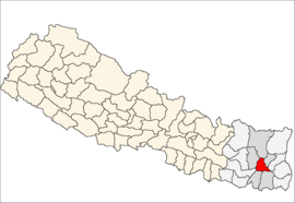
Dhankuta (Nepalees: धनकुटा) is een van de 75 districten van Nepal. Het district is gelegen in de Kosi-zone en de hoofdstad is Dhankuta.
District in Nepal | |||
 | |||
| Situering | |||
| Regio | Eastern (EDR) | ||
| Zone | Kosi (Koshi) | ||
| Coördinaten | 26°58'53"NB, 87°20'36"OL | ||
| Algemeen | |||
| Oppervlakte | 891 km² | ||
| Inwoners (2011) | 163.412[1] (183 inw./km²) | ||
| Hoofdstad | Dhankuta | ||
| |||

Steden en Dorpscommissies[2][3]
- Stad: Nepalees: nagarpalika of N.P.; Engels: municipality;
- Dorpscommissie: Nepalees: gāu bikās samiti; Engels: village development committee of VDC.
- Steden (1): Dhankuta.
- Dorpscommissies (35): Ahale, Ankhisalla, Arkhaule Jitpur, Basantatar, Belhara, Bhirgaun, Bodhe, Budhabare (of: Chha Nambar Budhabare, of: Chhanambar Budhabare), Budi Morang (of: Budhi Morang, Chanuwa, Chhintang, Chungwang (of: Chungmang), Danda Bazar (of: Danda Bajar), Dandagaun, Faksib, Falate, Ghorlinkarka (of: Ghorlikharka), Hatihikharka (of: Hattikharka), Khoku, Khuwafok (of: Khuwaphok), Kurule (of: Kurule Tenupa, of: Kuruletenupa), Leguwa, Mahabharat, Marek Katahhare (of: Marek Katahare), Mounabuduk (of: Maunabudhuk, of: Mauna Budhuk), Mudebas (of: Mudhebas), Muga, Murtidhunga, Pakhribas, Parewadin, Rajarani (of: Raja Rani), Sanne, Tankhuwa, Telia (of: Teliya), Vedetar (of: Bhedetar).
Bronnen, noten en/of referenties
|
| Districten van Nepal | |
|---|---|
|
Achham · Arghakhanchi · Baglung · Baitadi · Bajhang · Bajura · Banke · Bara · Bardiya · Bhaktapur · Bhojpur · Chitwan · Dadeldhura · Dailekh · Dang · Darchula · Dhading · Dhankuta · Dhanusa · Dolkha · Dolpa · Doti · Gorkha · Gulmi · Humla · Ilam · Jajarkot · Jhapa · Jumla · Kailali · Kalikot · Kanchanpur · Kapilvastu · Kaski · Kathmandu · Kavrepalanchok · Khotang · Lalitpur · Lamjung · Mahottari · Makwanpur · Manang · Morang · Mugu · Mustang · Myagdi · Nawalparasi · Nuwakot · Okhaldhunga · Palpa · Panchthar · Parbat · Parsa · Pyuthan · Ramechhap · Rasuwa · Rautahat · Rolpa · Rukum · Rupandehi · Salyan · Sankhuwasabha · Saptari · Sarlahi · Sindhuli · Sindhulpalchok · Siraha · Solukhumbu · Sunsari · Surkhet · Syangja · Tanahu · Taplejung · Terhathum · Udayapur | |
Geplaatst op: 23-11-2009 |
Dit artikel is een beginnetje over landen & volken. U wordt uitgenodigd om op bewerken te klikken om uw kennis aan dit artikel toe te voegen. |