Namib
The Namib (/ˈnæmiːb/; Portuguese: Namibe) is a coastal desert in southern Africa. The name Namib is of Khoekhoegowab origin and means "vast place". According to the broadest definition, the Namib stretches for more than 2,000 kilometres (1,200 mi) along the Atlantic coasts of Angola, Namibia, and South Africa, extending southward from the Carunjamba River in Angola, through Namibia and to the Olifants River in Western Cape, South Africa.[1][2][3] The Namib's northernmost portion, which extends 450 kilometres (280 mi) from the Angola-Namibia border, is known as Moçâmedes Desert, while its southern portion approaches the neighboring Kalahari Desert. From the Atlantic coast eastward, the Namib gradually ascends in elevation, reaching up to 200 kilometres (120 mi) inland to the foot of the Great Escarpment.[1] Annual precipitation ranges from 2 millimetres (0.079 in) in the most arid regions to 200 millimetres (7.9 in) at the escarpment, making the Namib the only true desert in southern Africa.[1][3][4] Having endured arid or semi-arid conditions for roughly 55–80 million years, the Namib may be the oldest desert in the world[1][4] and contains some of the world's driest regions, with only western South America's Atacama Desert to challenge it for age and aridity benchmarks.
| Namib | |
|---|---|
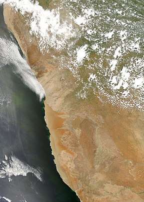 An image of the Namib Desert by the MODIS instrument | |
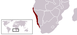 Approximate boundaries of the Namib Desert | |
| Length | 2,000 km (1,200 mi) |
| Width | 200 km (120 mi) |
| Area | 81,000 km2 (31,000 sq mi) |
| Geography | |
| Countries | Namibia, South Africa and Angola |
| Rivers | List
|
| Official name | Namib Sand Sea |
| Criteria | Natural: vii, viii, ix, x |
| Reference | 1430 |
| Inscription | 2013 (37th session) |
| Area | 3,077,700 ha |
| Buffer zone | 899,500 ha |
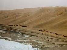
The desert geology consists of sand seas near the coast, while gravel plains and scattered mountain outcrops occur further inland. The sand dunes, some of which are 300 metres (980 ft) high and span 32 kilometres (20 mi) long, are the second largest in the world after the Badain Jaran Desert dunes in China.[1] Temperatures along the coast are stable and generally range between 9–20 °C (48–68 °F) annually, while temperatures further inland are variable—summer daytime temperatures can exceed 45 °C (113 °F) while nights can be freezing.[5] Fogs that originate offshore from the collision of the cold Benguela Current and warm air from the Hadley Cell create a fog belt that frequently envelops parts of the desert. Coastal regions can experience more than 180 days of thick fog a year.[1][4] While this has proved a major hazard to ships—more than a thousand wrecks litter the Skeleton Coast—it is a vital source of moisture for desert life.
The Namib is almost completely uninhabited by humans except for several small settlements and indigenous pastoral groups, including the Ovahimba and Obatjimba Herero in the north, and the Topnaar Nama in the central region.[3] Owing to its antiquity, the Namib may be home to more endemic species than any other desert in the world.[5] Most of the desert wildlife is arthropods and other small animals that live on little water, although larger animals inhabit the northern regions. Near the coast, the cold ocean water is rich in fishery resources and supports populations of brown fur seals and shorebirds, which serve as prey for the Skeleton Coast's lions.[5] Further inland, the Namib-Naukluft National Park, the largest game park in Africa, supports populations of African Bush Elephants, Mountain Zebras, and other large mammals. Although the outer Namib is largely barren of vegetation, lichens and succulents are found in coastal areas, while grasses, shrubs, and ephemeral plants thrive near the escarpment. Several types of trees are also able to survive the extremely arid climate.[5]
Geography and geology

.jpg)

The Namib Desert is one of the 500 distinct physiographic provinces of the South African Platform physiographic division. It occupies an area of around 80,950 km2[6] (31,200 square miles), stretching from the Usiab River (north) to the town of Lüderitz (south) and from the Atlantic Ocean (west) to the Namib Escarpment (east). It is about 1,000 miles (1,600 km) long from north to south and its east-west width varies from 30 to 100 miles (48 to 161 kilometres). To the north, the desert leads into the Kaokoveld; the dividing line between these two regions is roughly at the latitude of the city of Walvis Bay, and it consists in a narrow strip of land (about 50 km wide) that is the driest place in Southern Africa. To the south, the Namib borders on the South African Karoo semi-desert.
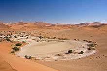
Southern Namib (between Lüderitz and the Kuiseb River) comprises a vast dune sea with some of the tallest and most spectacular dunes of the world, ranging in color from pink to vivid orange. In the Sossusvlei area, several dunes exceed 300 meters (980 feet) in height. The complexity and regularity of dune patterns in its dune sea have attracted the attention of geologists for decades, but it remains poorly understood.
The source of the unconsolidated sand (the most recent sand sea) has been shown to be dominantly from the Orange River, which drains into the Atlantic south of the Namib Sand Sea, with minor contributions in the east from the (now ephemeral) rivers that drain into the sand sea.[7] For this reason the Namib Sand Sea has been referred to as the "wind displaced delta of the Orange River."[7]
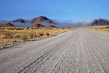
Moving north from Sossusvlei, the sand gradually gives way to a rocky desert that extends all the way from Sossusvlei to the Swakop river. This area is traversed by the Tropic of Capricorn and is mostly flat, although some scenic canyons and elevations are found in some areas, for example in the Moon Valley system. While most of the soil is rocky, sand dunes are still occasionally found in this region; for example, sand dunes occupy much of the coastline between Walvis Bay and Swakopmund.
The Namib desert is an important location for the mining of tungsten, salt and diamonds.
Several rivers and streams run through the Namib, although all of the rivers south of the Cunene River and north of the Orange River are ephemeral and rarely or never reach the ocean.[1][8] These rivers arise in the interior mountains of Namibia and flow after summer rain storms.[1]
Climate
The Namib's aridity is caused by the descent of dry air of the Hadley Cell, cooled by the cold Benguela current along the coast. It has less than 10 mm (0.39 in) of rain annually and is almost completely barren. Besides rain being scarce, it is also hardly predictable. The western Namib gets less rain (5 mm) than the eastern Namib (85 mm). This is due to several factors. Winds coming from the Indian Ocean lose part of their humidity when passing the Drakensberg mountains, and are essentially dry when they reach the Namib Escarpment at the eastern end of the desert. Winds coming from the Atlantic Ocean, on the other hand, are pressed down by hot air from the east; their humidity thus forms clouds and fog. Morning fogs coming from the ocean and pushing inwards into the desert are a regular phenomenon along the coast, and much of the life cycle of animals and plants in the Namib relies on these fogs as the main source of water.
The dry climate of the Namib reflects the almost complete lack of bodies of water on the surface. Most rivers flow underground and/or are dry for most of the year, and even when they are not, they usually drain into endorheic basins, without reaching the sea. The Swakop and the Omaruru are the only rivers that occasionally drain into the ocean.
All along the coast, but mostly in the northernmost part of it, interaction between the water-laden air coming from the sea via southerly winds, some of the strongest of any coastal desert, and the dry air of the desert causes immense fogs and strong currents. It causes sailors to lose their way; this is testified by the remnants of a number of shipwrecks that can be found along the Skeleton Coast, in northern Namib. Some of these wrecked ships can be found as much as 50 metres (55 yards) inland, as the desert slowly moves westwards into the sea, reclaiming land over a period of many years. Benguela's El Niño (similar to the Pacific event in its environmental change in the seas) spreads from the Kunene estuary southward to, on occasion, south of Luderitz. Warm waters with depth and associated water flows from the northwest were first fully catalogued by Sea Fisheries researchers, Cape Town (L V Shannon et al.). The research noted the positive effect of Benguela's El Niño on the rainfall of the interior. Rainfall records also show positive values variously across the Namib, Desert Research Station, Gobabeb for instance. This event recurs approximately mid-decade (1974, 1986, 1994, 1995 and 2006 are recent examples)
Animals and plants
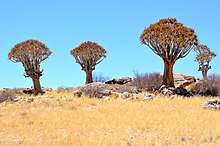
A number of unusual species of plants and animals are found in this desert, many of which are endemic and highly adapted to the specific climate of the area. One of the most well-known endemic plants of the Namib is the bizarre Welwitschia mirabilis; a shrub-like plant, it grows two long strap-shaped leaves continuously throughout its lifetime. These leaves may be several meters long, gnarled and twisted from the desert winds. The taproot of the plant develops into a flat, concave disc in age. Welwitschia is notable for its survival in the extremely arid conditions in the Namib, mostly deriving moisture from the coastal sea fogs. An area where Welwitschias are a common sight is found in the surroundings of the Moon Valley, including the eponymous Welwitschia Plains.
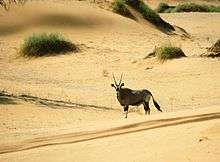
The Namib fauna mostly comprises arthropods and other small animals that can live on little water, but a few species of bigger animals are also found, including antelopes (such as oryxes and springboks), ostriches, and in some areas even desert elephants. All these species have developed techniques to survive in the Namib environment. A number of endemic darkling beetles species — such as the Namib Desert beetle — have bumpy elytrons with a pattern of hydrophilic bumps and hydrophobic troughs. These cause humidity from the morning fogs to condense into droplets, which roll down the beetle's back to its mouth; they are collectively known as "fog beetles". Another beetle, the Lepidochora discoidalis, builds "water-capturing" webs. Black-backed jackals lick humidity from stones. Gemsboks (also known as Oryxes) can raise the temperature of their bodies to 40 °C in the hottest hours of the day. The desert is also home to meerkats and several species of lizards.
Human activity
Before the 20th century, some San roamed the Namib, gathering edible plants on the shore, hunting in the interior, and drinking the juice of the tsamma melon for water. Today, some Herero still herd their livestock in the Kaokoveld in the Namib and take them from waterhole to waterhole. A few Nama Khoikhoi still graze their livestock on the banks of the Kuiseb River in the desert. Most of the native people have left, however, leaving the vast majority of the desert uninhabited.[9]
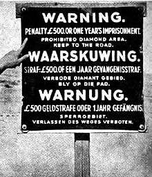
The steppes in the southern half of the desert are mostly made up of ranches run by Europeans, who raise Karakul sheep with local help and send the wool of the lambs to Europe for use in fur coats. Most of the rest of the desert is set aside for conservation. A vast portion of the desert, called the Sperrgebiet, was access-restricted due to the presence of diamonds, which are mined in the area at the mouth of the Orange River. Although the desert is largely unpopulated and inaccessible, there are year-round settlements at Sesriem, close to the famous Sossusvlei area, and other small outposts in other locations. Moçâmedes in Angola, and Lüderitz, Walvis Bay and Swakopmund in Namibia, bordering on the desert, are the main settlements in the area.
In 2019 the Namibian-German artist Max Siedentopf created an installation in the Namib consisting of a ring of large white blocks atop of which sit six speakers attached to a solar-powered MP3 player configured to continuously play the 1982 song "Africa" by the American band Toto. The exact location of the installation has not been disclosed.[10][11]
Namib-Naukluft National Park
.jpg)
The Namib-Naukluft National Park, that extends over a large part of the Namib Desert, is the largest game reserve in Africa and one of the largest of the world. While most of the park is hardly accessible, several well-known visitor attractions are found in the desert. The prominent attraction is the famous Sossusvlei area, where high orange sand dunes surround vivid white salt pans, creating a fascinating landscape.
Access to the park is either by gravel roads or dust roads (except for 60 km of concrete road from the Sesriem gate to Sossusvlei) or by light aircraft from Windhoek (the capital of Namibia, about 480 km (300 mi) north-east of the centre of the desert), or Swakopmund and Walvis Bay at the north end of the desert.
Notable places
- Bogenfels
- Moon Valley
- Sesriem
- Skeleton Coast
- Solitaire
- Sossusvlei
- Dune 45
- Deadvlei
- Hiddenvlei
- Spitzkoppe
- Welwitschia Plains
- Swakopmund
See also
- List of deserts by area
- Animals are Beautiful People, a nature documentary set in the Namib
References
- Goudie, Andrew (2010). "Chapter 17: Namib Sand Sea: Large Dunes in an Ancient Desert". In Migoń, Piotr (ed.). Geomorphological Landscapes of the World. New York, NY: Springer. pp. 163–169. ISBN 978-90-481-3054-2.
- Stone, A. E. C. (2013-06-01). "Age and dynamics of the Namib Sand Sea: A review of chronological evidence and possible landscape development models". Journal of African Earth Sciences. 82: 70–87. doi:10.1016/j.jafrearsci.2013.02.003. ISSN 1464-343X.
- Gates, Henry Louis; Appiah, Kwame Anthony, eds. (2010). Encyclopedia of Africa. 2. Oxford: Oxford University Press. p. 213. ISBN 978-0-19-533770-9.
- Spriggs, Amy. "Namib desert (AT1315)". Wild World. World Wildlife Fund. Retrieved 11 December 2011.
- Nicholson, Sharon E. (2011). Dryland Climatology. Cambridge: Cambridge University Press. pp. 385–388. ISBN 978-0-521-51649-5. Retrieved 13 December 2011.
- World Wildlife Fund, ed. (2001). "Namib desert". WildWorld Ecoregion Profile. National Geographic Society. Archived from the original on 2010-03-08.
- Garzanti, Eduardo; Andò, Sergio; Vezzoli, Giovanni; Lustrino, Michele; Boni, Maria; Vermeesch, Pieter (2012). "Petrology of the Namib Sand Sea: Long-distance transport and compositional variability in the wind-displaced Orange Delta". Earth-Science Reviews. 112 (3–4): 173–189. doi:10.1016/j.earscirev.2012.02.008.
- Stone, A. E. C.; Thomas, D. S. G. (2013-06-01). "Casting new light on late Quaternary environmental and palaeohydrological change in the Namib Desert: A review of the application of optically stimulated luminescence in the region". Journal of Arid Environments. Deserts of the World: Namib Desert: 50 years of research in a hyperarid desert. 93: 40–58. doi:10.1016/j.jaridenv.2012.01.009. ISSN 0140-1963.
- Logan, Richard F. "Namib | desert, Africa". Encyclopedia Britannica. Retrieved 2017-07-28.
- "Africa by Toto to play on eternal loop 'down in Africa'". BBC News. 14 January 2019.
- Aratani, Lauren (15 January 2019). "Toto forever: Africa to play 'for all eternity' in Namib desert". The Guardian. Retrieved 16 January 2019.
- National Geographic, January 1992, pp. 54–85.
- Mary Seely: The Namib: Natural History of an Ancient Desert, 3rd ed., Windhoek: Desert Research Foundation of Namibia 2004, ISBN 99916-68-16-0.
Further reading
- Tonchi, Victor L.; William A. Lindeke; John J. Grotpeter (2012). Historical Dictionary of Namibia (2nd ed.). Scarecrow Press. ISBN 978-0-8108-7990-4.
- Hamilton III, William J. (September 1983). "The Living Sands of the Namib". National Geographic. Vol. 164 no. 3. pp. 364–376. ISSN 0027-9358. OCLC 643483454.
External links
| Wikimedia Commons has media related to: |
- "Dune Patterns, Namib Desert, Namibia". NASA Earth Observatory. Retrieved 5 May 2006.
- Namib Naukluft Park photo gallery
- Namib Desert photo gallery