Tropic of Capricorn
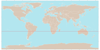
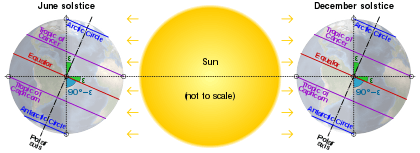
The Tropic of Capricorn (or the Southern Tropic) is the circle of latitude that contains the subsolar point on the December (or southern) solstice. It is thus the southernmost latitude where the Sun can be directly overhead. Its northern equivalent is the Tropic of Cancer.

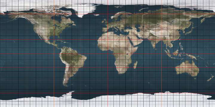
.jpg)

The Tropic of Capricorn is one of the five major circles of latitude that mark maps of Earth. Its latitude is currently 23°26′11.9″ (or 23.43665°)[1] south of the Equator, but it is very gradually moving northward, currently at the rate of 0.47 arcseconds, or 15 metres, per year.
Less than 3% of the world's population lives south of it, as well as about 30% of the population of the Southern Hemisphere.
Name
When this line of latitude was named in the last centuries BC, the Sun was in the constellation Capricornus at the December solstice. This is the date each year when the Sun reaches zenith at this latitude, the southernmost latitude it reaches for the year. (Due to the precession of the equinoxes the Sun currently appears in Sagittarius at this solstice.)
Geography and environment
The Tropic of Capricorn is the dividing line between the Southern Temperate Zone to the south and the tropics to the north. The Northern Hemisphere equivalent of the Tropic of Capricorn is the Tropic of Cancer.
The Tropic of Capricorn's position is not fixed, but constantly changes because of a slight wobble in the Earth's longitudinal alignment relative to its orbit around the Sun. Earth's axial tilt varies over a 41,000 year period from 22.1 to 24.5 degrees and currently resides at about 23.4 degrees. This wobble means that the Tropic of Capricorn is currently drifting northward at a rate of almost half an arcsecond (0.468″) of latitude, or 15 metres, per year (it was at exactly 23° 27′S in 1917 and will be at 23° 26'S in 2045). See under circles of latitude for information.
There are approximately 13 hours, 35 minutes of daylight during the summer solstice. During the winter solstice, there are 10 hours, 41 minutes of daylight.
Africa
In most of this belt of southern Africa, a minimum of seasonal rainfall is reliable and farming is possible, though yields struggle to compete with for example the Mississippi basin, even against like-to-like soil fertilisers. Rivers have been successfully dammed particularly flowing from relief precipitation areas (high emininences) and those from the edge of the Great Rift Valley, such as the Zambezi, well within the Tropics. This, with alluvial or enriched soil, enables substantial yield grain farming in areas with good soil. Across this large region pasture farming is widespread, where intensive, brief and rotational it helps to fertilise and stabilise the soil, preventing run-off and desertification.[2] This approach is traditional to many tribes and promoted by government advisors such as Allan Savory, a Zimbabwean-born biologist, farmer, game rancher, politician and international consultant and co-founder of the Savory Institute. According to the United Nations University Our World dissemination he is credited with developing “holistic management” in the 1960s and has led anti-desertification efforts in Africa for decades using a counterintuitive approach to most developed economies of increasing the number of livestock on grasslands rather than fencing them off for conservation. Such practices in this area have seen success and won generous awards; he gave the keynote speech at UNCCD's Land Day in 2018, and later that year a TED (conference) address, widely re-broadcast.[2]
Australia

In Australia, areas around the Tropic have some of the world's most variable rainfall.[3] In the east advanced plants such as flowering shrubs and eucalyptus and in most bioregions grasses have adapted to cope with means such as deep roots and little transpiration. Wetter areas, seasonally watered, are widely pasture farmed. As to animals, birds and marsupials are well-adapted. Naturally difficult arable agriculture specialises in dry fruits, nuts and modest water consumption produce. Other types are possible given reliable irrigation sources and, ideally, water-retentive enriched or alluvial soils, especially wheat; shallow irrigation sources very widely dry up in and after drought years. The multi-ridge Great Dividing Range brings relief precipitation enough to make hundreds of kilometres either side cultivable, and its rivers are widely dammed to store necessary water; this benefits the settled areas of New South Wales and Queensland.
Behind the end of the green hills, away from the Pacific, which is subject to warm, negative phases of the El Niño–Southern Oscillation (colloquially this is an "El Niño year/season") is a white, red and yellow landscape of 2,800 to 3,300 kilometres of rain shadow heading west in turn feature normally arid cattlelands of the Channel Country, the white Kati Thanda-Lake Eyre National Park, the mainly red Mamungari Conservation Park, then the Gibson Desert, after others the dry landscape settlement of Kalbarri on the west coast and its rest, northward. The Channel Country features an arid landscape with a series of ancient flood plains from rivers which only flow intermittently. The principal rivers are Georgina River, Cooper Creek and the Diamantina River. When there is sufficient rainfall in their catchment area these rivers flow into Lake Eyre, South Australia. In most years the flood waters are absorbed into the earth or evaporate, however. One of the most significant rainfall events occurred in 2010 when a monsoonal low from ex-Cyclone Olga created a period of exceptional rainfall.[4]
El Niño adverse phases cause a shift in atmospheric circulation; rainfall becomes reduced over Indonesia and Australia, rainfall and tropical cyclone formation increases over the tropical Pacific.[5] The low-level surface trade winds, which normally blow from east to west along the equator, either weaken or start blowing from the other direction.[5]
South America
In South America, whilst in the continental cratons soils are almost as old as in Australia and Southern Africa, the presence of the geologically young and evolving Andes means that this region is on the western side of the subtropical anticyclones and thus receives warm and humid air from the Atlantic Ocean. As a result, areas in Brazil adjacent to the Tropic are impressively productive agricultural regions, producing large quantities of crops such as sugarcane, and the natural rainforest vegetation has been almost entirely cleared, except for a few remaining patches of Atlantic Forest. Further south in Argentina, the temperate grasslands of the Pampas region is equally influential in wheat, soybeans, maize, and beef, making the country one of the largest worldwide agricultural exporters, similar to the role played by the Prairies region in Canada.
West of the Andes which creates a rain shadow air is further cooled and dried by the cold Humboldt Current which makes it very arid, creating the Atacama Desert, one of the driest in the world, so that no glaciers exist between Volcán Sajama at 18˚30'S and Cerro Tres Cruces at 27˚S.[6] Vegetation here is almost non-existent, though on the eastern slopes of the Andes rainfall is adequate for rainfed agriculture.
Around the world
Starting at the Prime Meridian and heading eastwards, the Tropic of Capricorn passes through 10 countries:
Co-ordinates Country, territory or ocean Notes 23°26′S 0°0′E Atlantic Ocean 23°26′S 14°27′E 
Erongo, Khomas, Hardap, Khomas (again), and Omaheke regions 23°26′S 20°0′E 
Kgalagadi, Kweneng and Central districts 23°26′S 27°18′E 
Limpopo Province 23°26′S 31°33′E 
Gaza and Inhambane provinces 23°26′S 35°26′E Indian Ocean Mozambique Channel 23°26′S 43°45′E 
Toliara and Fianarantsoa provinces 23°26′S 47°39′E Indian Ocean 23°26′S 113°47′E .svg.png)
Western Australia, Northern Territory and Queensland 23°26′S 151°3′E Pacific Ocean Coral Sea
Passing just south of Cato Reef in23°26′S 166°46′E Passing just north of the Minerva Reefs ( 
23°26′S 70°36′W 
Antofagasta Region 23°26′S 67°07′W 
Jujuy, Salta, Jujuy (again), Salta (again) and Formosa provinces 23°26′S 61°23′W 
Boquerón, Presidente Hayes, Concepción, San Pedro and Amambay departments 23°26′S 55°38′W 
Mato Grosso do Sul, Paraná, and São Paulo states 23°26′S 45°2′W Atlantic Ocean
Places located along the Tropic of Capricorn
The following cities and landmarks are either located near the Tropic of Capricorn, or the tropic passes through them.
|
|
|
 Atsimo-Andrefana Region, Madagascar
 The Tropic of Capricorn marked in Jujuy Province in northern Argentina
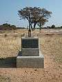 Monument marking the Tropic of Capricorn as it passes through Botswana
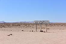
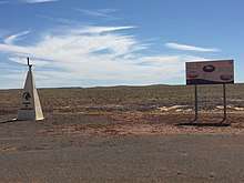
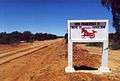
.jpg) A sign marking the Tropic of Capricorn as it passes through Namibia
A sign marking the Tropic of Capricorn as it passes through Namibia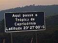 Roadway plaque marking the Tropic of Capricorn in the city of Santana do Parnaíba, Brazil, at the correct latitude for year 1917.
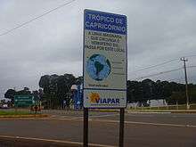
 Marker for the tropic in Maringá, Paraná, Brazil, July 2012
 Roadside monument marking Tropic of Capricorn in Rockhampton, Queensland, Australia, 28 January 2005
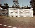 Monument marking Tropic of Capricorn in Rockhampton, Queensland, Australia, 1970
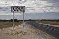 Road sign marking Tropic of Capricorn in Western Australia, Australia, 26 August 2008
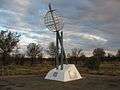 Monument marking the Tropic of Capricorn just north of Alice Springs, Northern Territory, Australia
List of countries entirely south of the Tropic of Capricorn
As most of earth's land is in the Northern Hemisphere only four countries are wholly south of the Tropic of Capricorn (which contrasts with 74, about one third of the current total, wholly north of the Tropic of Cancer):
- Eswatini (formerly Swaziland)
- Lesotho
- New Zealand[lower-alpha 1]
- Uruguay
Length
Length of the Tropic on 11 June 2015, at 23°26′14″S is 36,788 kilometres (22,859 mi).[7]
Note
- The Cook islands, Tokelau and Niue, which are part of the Realm of New Zealand, lie above the Tropic of Capricorn.
References
- "obliquity of the ecliptic (Eps Mean)". Archived from the original on 12 June 2017. Retrieved 10 March 2012.
- "Archived copy". Archived from the original on 8 April 2019. Retrieved 7 September 2019.CS1 maint: archived copy as title (link)
- Geographical Patterning of Interannual Rainfall Variability in the Tropics and Near Tropics
- "Channel Country rain will boost cattle feed". ABC Rural. Australian Broadcasting Corporation. 3 February 2010. Archived from the original on 11 November 2012. Retrieved 18 May 2010.
- "What is El Niño and what might it mean for Australia?". Australian Bureau of Meteorology. Archived from the original on 18 March 2016. Retrieved 10 April 2016.
- "Exposure dating of Late Glacial and pre-LGM moraines in the Cordon de Doña Rosa, Northern/Central Chile (~31°S)" (PDF). Archived (PDF) from the original on 28 July 2014. Retrieved 16 January 2012.
- RhumbSolve online rhumb line calculator Archived 3 December 2016 at the Wayback Machine.
External links
| Wikimedia Commons has media related to Tropic of Capricorn. |
| Look up tropic of capricorn in Wiktionary, the free dictionary. |
- Temporal Epoch Calculations
- Useful constants" See: Obliquity of the ecliptic
- Montana State University: Milankovitch Cycles & Glaciation
See also
- Circle of latitude
- Arctic Circle
- Tropic of Cancer
- Equator
- 23rd parallel south
- 24th parallel south
- Antarctic Circle
- Axial tilt
- Milankovitch cycles
- Capricornus
Circles of latitude / meridians | |
|---|---|
 30°
60°
90°
120°
150°
180°
30°
60°
90°
120°
150°
180°
5°
15°
25°
35°
45°
55°
65°
75°
85°
95°
105°
115°
125°
135°
145°
155°
165°
175°
5°
15°
25°
35°
45°
55°
65°
75°
85°
95°
105°
115°
125°
135°
145°
155°
165°
175°
10°
20°
40°
50°
70°
80°
100°
110°
130°
140°
160°
170°
10°
20°
40°
50°
70°
80°
100°
110°
130°
140°
160°
170°
10°
20°
30°
40°
50°
60°
70°
80°
10°
20°
30°
40°
50°
60°
70°
80°
5° N
15°
25°
35°
45°
55°
65°
75°
5° S
15°
25°
35°
45°
55°
65°
75°
45x90
45x90
45x90
45x90
|