Taklamakan Desert
The Taklamakan Desert (/ˌtæk.lə.məˈkæn/; Chinese: 塔克拉玛干沙漠; pinyin: Tǎkèlāmǎgān Shāmò, Xiao'erjing: تَاكْلامَاقًا شَاموْ; Dungan: Такәламаган Шамә; Uyghur: تەكلىماكان قۇملۇقى ; also spelled Taklimakan and Teklimakan) is a desert in Southwest Xinjiang in Northwest China. It is bounded by the Kunlun Mountains to the south, the Pamir Mountains and Tian Shan (ancient Mount Imeon) to the west and north and the Gobi Desert to the east.
| Taklamakan Desert | |||||||||||||||||
|---|---|---|---|---|---|---|---|---|---|---|---|---|---|---|---|---|---|
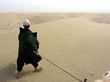
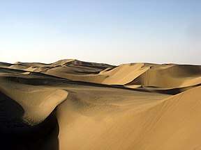 View of the Taklamakan desert | |||||||||||||||||
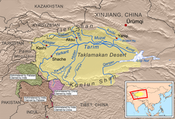 Taklamakan Desert and Tarim Basin | |||||||||||||||||
| Area | 337,000 km2 (130,000 sq mi) | ||||||||||||||||
| Geography | |||||||||||||||||
| Country | China | ||||||||||||||||
| State/Province | Xinjiang | ||||||||||||||||
| Coordinates | 38.9°N 82.2°E | ||||||||||||||||
| Chinese name | |||||||||||||||||
| Traditional Chinese | 塔克拉瑪干沙漠 | ||||||||||||||||
| Simplified Chinese | 塔克拉玛干沙漠 | ||||||||||||||||
| |||||||||||||||||
| Dunganese name | |||||||||||||||||
| Dungan | Такәламаган Шамә | ||||||||||||||||
| Uyghur name | |||||||||||||||||
| Uyghur | تەكلىماكان قۇملۇقى | ||||||||||||||||
| |||||||||||||||||
Etymology
The word "Taklamakan" may be a Uyghur borrowing of the Persian tark, "to leave alone/out/behind, relinquish, abandon" + makan, "place".[1][2] Another plausible explanation suggests it is derived from Turki taqlar makan, describing "the place of ruins".[3][4] In folk etymology, it is said to mean "Place of No Return", more commonly interpreted as "once you get in, you'll never get out" or similar.[5][6][7][8]
Geography
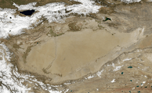
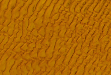
The Taklamakan Desert has an area of 337,000 km2 (130,000 sq mi),[9] making it slightly smaller than Germany and is part of the Tarim Basin, which is 1,000 kilometres (620 mi) long and 400 kilometres (250 mi) wide. It is crossed at its northern and at its southern edge by two branches of the Silk Road as travellers sought to avoid the arid wasteland.[10] It is the world's second largest shifting sand desert with about 85% made up of shifting sand dunes[11] ranking 16th in size in a ranking of the world's largest deserts.[12]
The People's Republic of China has constructed two cross-desert highways. The Tarim Desert Highway links the cities of Hotan (on the southern edge) and Luntai (on the northern edge) and the Bayingol to Ruoqiang road crosses the desert to the east.
In recent years, the desert has expanded in some areas, its sands enveloping farms and villages as a result of desertification.
"When I woke up one morning, I found I couldn't open the door because of the weight of sand that had accumulated overnight. My crops were buried too, so I had no choice but to move" -Memet Simay, Qira County resident[13]
The Golmud-Korla Railway (presently, under construction; expected completion time, 2019) will cross the Taklamakan as well.
Named areas in the desert include Ha-la-ma, A-lang-ha and Mai-k'o-tsa-k'o.[14] The Mazartag mountains are located in the western part of the desert.
Climate
Because it lies in the rain shadow of the Himalayas, Taklamakan is a paradigmatic cold desert climate. Given its relative proximity with the cold to frigid air masses in Siberia, extreme temperatures are recorded in wintertime, sometimes well below −20 °C (−4 °F), while in summer they can rise up to 40 °C (104 °F). During the 2008 Chinese winter storms episode, the Taklamakan was reported to be covered, for the first time in its recorded history, entirely with a thin layer of snow reaching 4 centimetres (1.6 in), with a temperature of −26.1 °C (−15 °F) in some observatories.[15]
Its extreme inland position, virtually in the very heartland of Asia and thousands of kilometres from any open body of water, accounts for the somewhat wide diurnal temperature variation.
Oasis
_p61_PLATE19._SINKIANG_(14597194848).jpg)
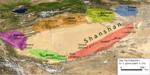
The Taklamakan Desert has very little water, therefore it is hazardous to cross. Merchant caravans on the Silk Road would stop for relief at the thriving oasis towns.[17] It was in close proximity to many of the ancient civilizations — to the Northwest is the Amu Darya basin, to the southwest the Afghanistan mountain passes lead to Iran and India, to the east is China, and even to the north ancient towns such as Almaty can be found.
The key oasis towns, watered by rainfall from the mountains, were Kashgar, Miran, Niya, Yarkand, and Khotan (Hetian) to the south, Kuqa and Turpan in the north, and Loulan and Dunhuang in the east.[10] Now, many, such as Miran and Gaochang, are ruined cities in sparsely inhabited areas in the Xinjiang Autonomous Region of the People's Republic of China.[18]
The archaeological treasures found in its sand-buried ruins point to Tocharian, early Hellenistic, Indian, and Buddhist influences. Its treasures and dangers have been vividly described by Aurel Stein, Sven Hedin, Albert von Le Coq, and Paul Pelliot.[19] Mummies, some 4000 years old, have been found in the region.[20]
Later, the Taklamakan was inhabited by Turkic peoples. Starting with the Han Dynasty, the Chinese sporadically extended their control to the oasis cities of the Taklamakan Desert in order to control the important silk route trade across Central Asia. Periods of Chinese rule were interspersed with rule by Turkic, Mongol and Tibetan peoples. The present population consists largely of Turkic Uyghur people and ethnic Han people.[21]
Scientific exploration
This desert was explored by several scientists such as Xuanzang, a monk in the 7th century and by the archaeologist Aurel Stein in the 20th century.
Atmospheric studies have shown that dust originating from the Taklamakan is blown over the Pacific, where it contributes to cloud formation over the Western United States. Studies have shown that a specific class of mineral found in the dust, known as K-feldspar, triggers ice formation particularly well. K-feldspar is particularly susceptible to corrosion by acidic atmospheric pollution such as nitrates and phosphates. Exposure to these constituents reduces the ability of the dust to trigger water droplet formation. Further, the traveling dust redistributes minerals from the Taklamakan to the western U.S.A. via rainfall.[22]
In popular culture
The desert is the main setting for Chinese film series Painted Skin and Painted Skin: The Resurrection. The Chinese TV series Candle in the Tomb is mostly spent in this desert as they are searching for the ancient city of Jinjue (see Niya (Tarim Basin).)
The issue #39 'Soft Places' of Neil Gaiman's The Sandman takes place in the desert, when Marco Polo gets lost in the desert.
A portion of the Korean quasi-historical TV drama series Queen Seondeok takes place in the Taklamakan Desert. Sohwa escapes from Silla with baby Deokman and raises her in the desert. As a teenager, Deokman returns to Silla and uses the knowledge and experience gained from life among international traders in the Taklamakan trading centers to gain the throne of Silla.
The desert is showcased in the Japanese animation Gundam 00, set in the year 2307. On the series, the Taklamakan Desert is the setting of a large-scale military joint operation performed by all the world's blocks of power, and interdicted by the paramilitary organization Celestial Being.
Code Geass depicts a fictionalized version of Taklamakan Desert within the Chinese Federation, one of three superstates in the series. It serves as the setting of a key battle between the Holy Britannian Empire and Japanese insurrectionists backed by the Chinese Federation. Later, the presence of an underground city is revealed, where members of the Geass Order are being used by Emperor Charles zi Britannia and his consort Marianne vi Britannia to bring about the Ragnarök Connection.
In the third book of the Temeraire series, Black Powder War by Naomi Novik, Captain Laurence and his crew must cross the desert to return home to England from China.
See also
- Bezeklik Caves
- Cities along the Silk Road
- List of deserts by area – Wikipedia list article
- Tarim Basin
- Tarim mummies – A series of mummies discovered in the Tarim Basin
- Turpan water system
References
Citations
- Pospelov, E. M. (1998). Geograficheskiye nazvaniya mira. Moscow. p. 408.
- Jarring, Gunnar (1997). "The Toponym Takla-makan". Turkic Languages. 1: 227–40.
- Tamm (2011), p. 139.
- "Takla Makan Desert at TravelChinaGuide.com". Archived from the original on 2008-10-25. Retrieved 2008-11-24. But see Christian Tyler, Wild West China, John Murray 2003, p.17
- Golden, Peter B. Central Asia in World History. Oxford University Press. p. 16. ISBN 9780199722037.
- Hobbs, Joseph J. (14 December 2007). World Regional Geography (6th ed.). Wadsworth Publishing Co Inc. p. 368. ISBN 978-0495389507. Archived from the original on 19 February 2017. Retrieved 5 December 2016.
- Baumer, Christoph (2008-06-30). Traces in the Desert: Journeys of Discovery Across Central Asia. B. Tauris & Company. p. 141. ISBN 9780857718327. Archived from the original on 2017-02-19. Retrieved 2016-12-05.
- Hopkirk, Peter (1 November 2001). Foreign Devils on the Silk Road: The Search for the Lost Treasures of Central Asia. Oxford University Press. p. 12. ISBN 978-0192802118. Archived from the original on 19 February 2017. Retrieved 5 December 2016.
- Sun, Jimin; Lou, Tungsten (2006). "The Age of the Taklimakan Desert". Science. 312 (5780): 1621. doi:10.1126/science.1124616. PMID 16778048.
- Ban, Paul G. (2000). The Atlas of World Archeology. New York: Check mark Books. pp. 134&n dash, 135. ISBN 978-0-8160-4051-3.
- "Taklamakan Desert". Encyclopædia Britannica. Archived from the original on 2007-09-29. Retrieved 2007-08-11.
- "The World's Largest Desert". geology.com. Archived from the original on 2007-08-17. Retrieved 2007-08-22.
- "Holding back the sands of time". China Daily. 27 May 2013. Retrieved 15 December 2019.
Memet Simay's household was one of 446 in Qira township forced to relocate in the 1980s, although the family has since returned to the area. "When I woke up one morning, I found I couldn't open the door because of the weight of sand that had accumulated overnight. My crops were buried too, so I had no choice but to move," he recalled.
- "NJ 44 Ho-tien [China, India] Series 1301, Edition 3-TPC". Washington, D. C.: U.S. Army Topographic Command. 1971 – via Perry–Castañeda Library Map Collection.
KJ A-LANG-HA HA-LA-MA MAI-K'O-TSA-K'O LH{...}LEGEND{...}AREA NAME HA-LA-MA
- "China's biggest desert Taklamakan experiences record snow". Xinhuanet.com. February 1, 2008. Archived from the original on February 8, 2008. Retrieved February 4, 2008.
- "38°53'28.0"n 82°10'40.0"e".
- Hopkirk, Peter (2001). Spies Along the Silk Road. ISBN 9780192802323. Archived from the original on 2017-01-09. Retrieved 2007-08-07.
- Whitfield, Susan; Library, British (2004). The Silk Road: Trade, Travel, War and Faith. ISBN 9781932476132. Archived from the original on 2016-05-09. Retrieved 2007-08-25.
- "The Silk Road". Archived from the original on 2016-03-15. Retrieved 2007-08-07.
- Wade, Nicholas (2010-03-15). "A Host of Mummies, a Forest of Secrets". The New York Times. Archived from the original on 2014-12-28. Retrieved 2014-12-28.
- Xinjiang territory profile Archived 2018-07-01 at the Wayback Machine, BBC News. May 7, 2011.
- Fox, Douglas (2014-12-22). "The Dust Detectives". High Country News. Vol. 46 no. 22. Archived from the original on 2017-08-19. Retrieved 2017-09-02.
!["NJ 44 Ho-tien [China, India] Series 1301, Edition 3-TPC"](http://legacy.lib.utexas.edu/maps/imw/txu-oclc-6654394-nj-44-3rd-ed.jpg)
Sources
- Jarring, Gunnar (1997). "The toponym Takla-makan", Turkic Languages, Vol. 1, pp. 227–240.
- Hopkirk, Peter (1980). Foreign Devils on the Silk Road: The Search for the Lost Cities and Treasures of Chinese Central Asia. Amherst: The University of Massachusetts Press. ISBN 0-87023-435-8.
- Hopkirk, Peter (1994). The Great Game: The Struggle for Empire in Central Asia. ISBN 1-56836-022-3.
- Tamm, Eric Enno (2010). The Horse That Leaps Through Clouds. Vancouver/Toronto/Berkeley: Douglas & McIntyre. ISBN 9781553652694 (cloth); ISBN 978-1-55365-638-8 (ebook).
- Warner, Thomas T. (2004). Desert Meteorology. Cambridge University Press, 612 pages. ISBN 0-521-81798-6.
Further reading
- Cariou, Alain (2010). "Taklamakan". Encyclopaedia Iranica.CS1 maint: ref=harv (link)
Videography
- Treasure seekers : China's frozen desert, National Geographic Society (2001)
External links
| Wikimedia Commons has media related to Taklamakan. |