Isle Royale National Park
Isle Royale National Park is an American national park consisting of Isle Royale and hundreds of adjacent islands, as well as the surrounding waters of Lake Superior, in the state of Michigan. Isle Royale National Park was established on April 3, 1940, then additionally protected from development by wilderness area designation in 1976, and declared a UNESCO International Biosphere Reserve in 1980. The park covers 894 square miles (2,320 km2), with 209 square miles (540 km2) of land and 685 square miles (1,770 km2) of surrounding waters. The park's northern boundary lies adjacent to the Canadian Lake Superior National Marine Conservation Area along the international border.
| Isle Royale National Park | |
|---|---|
IUCN category V (protected landscape/seascape) | |
 An aerial view of Isle Royale | |
 Location in the United States  Location in Michigan | |
| Location | Keweenaw County, Michigan, United States |
| Nearest city | Thunder Bay, Ontario |
| Coordinates | 48°6′0″N 88°33′0″W |
| Area | 571,790 acres (2,314.0 km2)[1] |
| Established | April 3, 1940 |
| Visitors | 25,798 (in 2018)[2] |
| Governing body | National Park Service |
| Website | www |

Geography
Isle Royale, the largest island in Lake Superior, is over 45 miles (72 km) in length and 9 miles (14 km) wide at its widest point.[3] The park is made up of Isle Royale itself and approximately 400 smaller islands, along with any submerged lands within 4.5 miles (7.2 km) of the surrounding islands (16USC408g).[4]
Climate
According to the Köppen climate classification system, Isle Royale National Park has a mild summer Humid continental climate (Dfb). According to the United States Department of Agriculture, the Plant Hardiness zone is 4b at 1178 ft (359 m) elevation with an average annual extreme minimum temperature of -24.2 °F (-31.2 °C). [5]
| Climate data for Isle Royale National Park. Elev: 1184 ft (361 m) | |||||||||||||
|---|---|---|---|---|---|---|---|---|---|---|---|---|---|
| Month | Jan | Feb | Mar | Apr | May | Jun | Jul | Aug | Sep | Oct | Nov | Dec | Year |
| Average high °F (°C) | 17.6 (−8.0) |
24.0 (−4.4) |
35.2 (1.8) |
45.9 (7.7) |
57.9 (14.4) |
66.1 (18.9) |
72.1 (22.3) |
71.8 (22.1) |
63.0 (17.2) |
49.2 (9.6) |
34.9 (1.6) |
22.5 (−5.3) |
46.8 (8.2) |
| Daily mean °F (°C) | 8.4 (−13.1) |
13.6 (−10.2) |
24.2 (−4.3) |
35.9 (2.2) |
46.8 (8.2) |
56.0 (13.3) |
61.7 (16.5) |
61.2 (16.2) |
53.4 (11.9) |
41.1 (5.1) |
28.1 (−2.2) |
14.9 (−9.5) |
37.2 (2.9) |
| Average low °F (°C) | −0.8 (−18.2) |
3.3 (−15.9) |
13.2 (−10.4) |
25.8 (−3.4) |
35.7 (2.1) |
46.0 (7.8) |
51.4 (10.8) |
50.6 (10.3) |
43.7 (6.5) |
33.0 (0.6) |
21.2 (−6.0) |
7.3 (−13.7) |
27.6 (−2.4) |
| Average precipitation inches (mm) | 1.97 (50) |
1.18 (30) |
1.62 (41) |
2.14 (54) |
2.80 (71) |
3.15 (80) |
3.26 (83) |
3.02 (77) |
3.17 (81) |
3.22 (82) |
2.39 (61) |
2.03 (52) |
29.95 (761) |
| Average relative humidity (%) | 78.9 | 73.2 | 66.6 | 59.1 | 60.9 | 68.5 | 69.7 | 73.9 | 76.5 | 75.4 | 76.6 | 81.6 | 71.7 |
| Average dew point °F (°C) | 3.2 (−16.0) |
6.6 (−14.1) |
14.7 (−9.6) |
23.0 (−5.0) |
34.0 (1.1) |
45.8 (7.7) |
51.7 (10.9) |
52.8 (11.6) |
46.2 (7.9) |
33.9 (1.1) |
21.7 (−5.7) |
10.3 (−12.1) |
28.8 (−1.8) |
| Source: PRISM Climate Group[6] | |||||||||||||
History
Prehistoric
Large quantities of copper artifacts found in indian mounds and settlements, some dating back to 3000 B.C., were most likely mined on Isle Royale and the nearby Keweenaw Peninsula. The island has hundreds of pits from these indigenous peoples, with most in the McCargoe Cove area. Carbon-14 testing of a charred log found at one of these pits yielded an age of 1,500 B.C. The Jesuit missionary Dablon published an account in 1669-70 of "an island called Menong, celebrated for its copper." Menong, or Minong, was the native term for the island, and is the basis for Minong Ridge. Prospecting began in earnest when the Chippewas relinquished their claims to the island in 1843, starting with many of the original native pits. This activity had ended by 1855, when no economic deposits were found. The Minong Mine and Island Mine were the result of renewed but short-lived activity from 1873 to 1881.[7]
In Prehistoric Copper Mining in the Lake Superior Region, published in 1961, Drier and Du Temple estimated that over 1.5 billion pounds (630,400 t) of copper had been mined from the region. However, David Johnson and Susan Martin contend that their estimate was based on exaggerated and inaccurate assumptions.[8][9]
19th & 20th centuries
In the mid-1840s, a report by Douglass Houghton, Michigan's first state geologist, set off a copper boom in the state, and the first modern copper mines were opened on the island.[10] Evidence of the earlier mining efforts was everywhere, in the form of many stone hammers, some copper artifacts, and places where copper had been partially worked out of the rock but left in place. The ancient pits and trenches led to the discovery of many of the copper deposits that were mined in the 19th century.[8]
The island was once the site of a resort community. The fishing industry has declined considerably, but continues at Edisen Fishery. Because numerous small islands surround Isle Royale, ships were once guided through the area by lighthouses at Passage Island, Rock Harbor, Rock of Ages, and Isle Royale Lighthouse on Menagerie Island.
Within the waters of Isle Royale National Park are several shipwrecks. The area’s notoriously harsh weather, dramatic underwater topography, the island’s central location on historic shipping routes, and the cold, fresh water have resulted in largely intact, well preserved wrecks throughout the park. These were documented in the 1980s, with follow up occurring in 2009, by the National Park Service Submerged Resources Center.
Natural history
Flora
According to the A. W. Kuchler U.S. Potential natural vegetation Types, Isle Royale National Park has a Great Lakes Spruce/Fir (93) potential vegetation type and a Northern Conifer Forest (22) potential vegetation form [11].
The predominant floral habitats of Isle Royale are within the Laurentian Mixed Forest Province. The area is a temperate broadleaf and mixed forests biome transition zone between the true boreal forest to the north and Big Woods to the south, with characteristics of each. It has areas of both broadleaf and conifer forest cover, and bodies of water ranging from conifer bogs to swamps.[12]
Conifers include jack pines (Pinus banksiana), black and white spruces (Picea mariana and Picea glauca), balsam firs (Abies balsamea), and eastern redcedars (Juniperus virginiana).
Deciduous trees include quaking aspens (Populus tremuloides), red oaks (Quercus rubra), paper birches (Betula papyrifera), American mountain ash (Sorbus americana), red maples (Acer rubrum), sugar maples (Acer saccharum), and mountain maples (Acer spicatum).[13][14]
Fauna
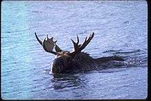
Isle Royale National Park is known for its timber wolf and moose populations which are studied by scientists investigating predator-prey relationships in a closed environment. This is made easier because Isle Royale has been colonized by roughly just one third of the mainland mammal species, because it is so remote.[15] In addition, the environment is unique in that it is the only known place where wolves and moose coexist without the presence of bears.[16]
Historically neither moose nor wolves inhabited Isle Royale. Just prior to becoming a national park the large mammals on Isle Royale were Canada lynx and the boreal woodland caribou. Archeological evidence indicates both of these species were present on Isle Royale for 3,500 years prior to being removed by direct human actions (hunting, trapping, mining, logging, fires, competition for resources from exotic species and possibly disease due to the introduction of invasive species). The last caribou documented on Isle Royale was in 1925. Though lynx were removed by the 1930s some have periodically crossed the ice bridge from neighboring Ontario, Canada, the most recent being an individual sighting in 1980.[17] Although lynx are no longer present on the island, their primary prey, snowshoe hares, remain. Before the appearance of wolves, coyotes were also predators on the island. Coyotes appeared around 1905 and disappeared shortly after wolves arrived in the 1950s.
Moose are believed to have colonized Isle Royale sometime between 1905 and 1912. It was initially believed that a small herd of moose (moose typically do not travel in herds) colonized the islands by crossing the ice from the adjacent mainland; later this theory was modified to a herd of moose swimming 20 miles across Lake Superior from the nearest mainland. The improbability of these theories received little scrutiny until recent years. Although no thorough scientific investigation to determine how moose arrived on Isle Royale has been carried out to date, both cultural and genetic evidence indicates they were likely introduced by humans to create a private hunting preserve in the early 1900s. The cultural evidence that moose were trapped in northwestern Minnesota and transported to Isle Royale sounded far fetched to many until decades later when genetic evidence revealed the moose on Isle Royale were more closely related to moose in the far northwestern Minnesota/Manitoba border area than the mainland adjacent to Isle Royale in far northeastern Minnesota bordering Ontario. Further evidence has also shown that the Washington Harbor Club, a group of well-to-do businessmen, owned various buildings on Isle Royale in addition to railroads that ran from Baudette to Duluth and Two Harbors and so had the means to transport moose from northwestern Minnesota to Two Harbors.[18][19]
There are usually around 25 wolves and 1000 moose on the island, but the numbers change greatly year to year. In the 2006-2007 winter, 385 moose were counted, as well as 21 wolves, in three packs. In spring 2008, 23 wolves and approximately 650 moose were counted.[20] However, recent reductions in winter pack ice have ended replenishment of the wolf population from the mainland.[21] Due to genetic inbreeding, wolf populations had declined to only two in 2016, and the current population will not survive.[22] By November 2017, the population was down to one, a female.[21]
In December 2016, the National Park Service (NPS) put forward an initial plan in which they would bring additional wolves to the island in order to prevent the pack from disappearing completely.[23] As of June 7, 2018, the decision to relocate 20-30 wolves to the island has been approved and the NPS is actively developing specific implementation strategies.[24] There was some debate as to whether or not the introduction was an unnatural intervention.[25]
Geology
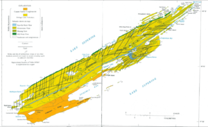
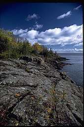
The two main rock assemblages found on the island include the Portage Lake Volcanics and the Copper Harbor Conglomerate, both Precambrian in age. The volcanics are mainly ophitic flood basalts, some 100 individual flows over an accumulated thickness of at least 10,000 feet. The conglomerate outcrops on the southwestern portion of the island and consists of sedimentary rock derived from volcanic rocks in present-day Minnesota. Glacial erosion accentuated the ridge and valley topography from pre-glacial stream erosion. Glacial striations indicate a generally westward movement of the glaciers as do the recessional moraines west of Lake Desor. Drumlins are found west of Siskiwit Lake.[7]:8,14-15,21,25,42,45
Recent analyses by the USGS of both unmineralized basalt and copper-mineralized rock show that a small amount of naturally occurring mercury is associated with mineralization.
Native copper and chlorastrolite, the official state gem of Michigan, are secondary minerals filling pore spaces formed by vesicles and fractures within the volcanic rocks. Prehnite and agate amygdules are also plentiful island gemstones.[7]:55,58-61
Recreation
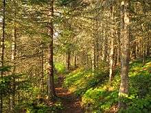
The Greenstone Ridge is a high ridge in the center of the island and carries the longest trail in the park, the Greenstone Ridge Trail, which runs 40 miles (64 km) from one end of the island to the other. This is generally done as a 4 or 5 day hike. A boat shuttle can carry hikers back to their starting point. In total there are 165 miles (266 km) of hiking trails. There are also canoe/kayak routes, many involving portages, along coastal bays and inland lakes.
Services
The park has two developed areas:
Windigo, at the southwest end of the island (docking site for the ferries from Minnesota), with a campstore, showers, campsites, rustic camper cabins for those wanting to sleep off of the ground and a boat dock.
Rock Harbor on the south side of the northeast end (docking site for the ferries from Michigan), with a campstore, showers, restaurant, lodge, campsites, and a boat dock. Non-camping sleeping accommodations at the park are limited to the lodge at Rock Harbor and the camper cabins at Windigo.
Camping
The park has 36 designated wilderness campgrounds. Some campgrounds in the interior are accessible only by trail or by canoe/kayak on the island lakes. Other campgrounds are accessible only by private boat. The campsites vary in capacity but typically include a few three-sided wood shelters (the fourth wall is screened) with floors and roofs, and several individual sites suitable for pitching a small tent. Some tent sites with space for groups of up to 10 are available, and are used for overflow if all the individual sites are filled.
The only amenities at the campgrounds are pit toilets, picnic tables, and fire-rings at specific areas. Campfires are not permitted at most campgrounds; gas or alcohol camp stoves are recommended. Drinking and cooking water must be drawn from local water sources (Lake Superior and inland lakes) and filtered, treated, or boiled to avoid parasites. Hunting is not permitted, but fishing is, and edible berries (blueberries, thimbleberries) may be picked from the trail.
Access
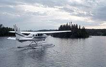
The park is accessible by ferries, floatplanes, and passenger ships during the summer months—from Houghton and Copper Harbor in Michigan; and Grand Portage in Minnesota. Private boats travel to the island from the coasts of Michigan, Minnesota, and Ontario. Isle Royale is quite popular with day-trippers in private boats, and day-trip ferry service is provided from Copper Harbor and Grand Portage to and from the park.
Isle Royale is the only American national park to entirely close in the winter months, from November 1 through April 15, due to extreme weather conditions and for the safety and protection of visitors.[26] Isle Royale is the least-visited national park in the contiguous United States, due to the winter closing and the distance across Lake Superior to reach the park. The average annual visitation was about 19,000 in the period from 2009 to 2018, with 25,798 visiting in 2018.[2] It is the least visited national park in the lower 48 states.[25] Only three of the most remote Alaskan national parks—Lake Clark, Kobuk Valley and Gates of the Arctic—receive fewer visitors.[2]
Ships
Scheduled ferry service operates from Grand Portage, Copper Harbor and Houghton.
The Grand Portage ferries reach the island in 1 1/2 hours, and stay 4 hours at the island, allowing time for hiking, a guided hike or program by the park staff, and picnics.
The Isle Royale Queen serves park visitors out of Copper Harbor, on the northern Upper Peninsula coast of Michigan. It arrives at Rock Harbor in the park in 3 to 3 1/2 hours, spends 3 1/2 hours before returning to Copper Harbor.
The Sea Hunter operates round-trips and offers day trips to the Windigo visitor center through much of the season, and less frequently in early summer and autumn; it will transport kayaks and canoes for visitors wanting to explore the park from the water. It is the fastest ferry serving the island and arrives in 1 1/2 hours, including some sightseeing points along the way out and back. Because of the relatively short boat ride, day visitors are able to get four hours on the island, and get back to the mainland earlier in the afternoon. This gives visitors on a tight schedule time to visit the Grand Portage National Monument or other attractions in the same day.
The Ranger III is a 165-foot (50 m) ship that serves park visitors from Houghton, Michigan to Rock Harbor. It is operated by the National Park Service, and is said to be the largest piece of equipment in the National Park system. It carries 125 passengers, along with canoes, kayaks, and even small powerboats. It is a six-hour voyage from Houghton to the park. The ship stays overnight at Rock Harbor before returning the next day, making two round trips each week from June to mid-September. Briefly in the 2008 season, the Ranger III carried visitors to and from Windigo. This was not continued after four trips, due to low interest and long crossing times. In 2012, Park Superintendent Phyllis Green required the Ranger III to purify its ballast water.[27]
The Voyageur II, out of Grand Portage, crosses up to three times a week, overnighting at Rock Harbor and providing transportation between popular lakeside campgrounds. In the fall season, in addition to carrying campers and hikers, it provides day-trip service to Windigo on weekends. The Voyageur transports kayaks and canoes for visitors wanting to explore the island from the water. The Voyageur II and other boat taxi services ferry hikers to points along the island, allowing a one-way hike back to Rock Harbor or Windigo. Visitors may land at Rock Harbor and depart from Windigo several days later, or vice versa. Hikers frequently ride it in one direction to do a cross-island hike and then get picked up at the other end.
See also
- List of islands in Isle Royale National Park
- List of fish of Isle Royale National Park
- List of birds of Isle Royale National Park
- List of shipwrecks of Isle Royale
- List of national parks of the United States
- National Register of Historic Places listings in Isle Royale National Park
References
- "Listing of acreage as of December 31, 2011". Land Resource Division, National Park Service. Retrieved March 7, 2012.
- "NPS Annual Recreation Visits Report". National Park Service. Retrieved March 7, 2019.
- "Isle Royale National Park". National Park Service. Retrieved October 13, 2005.
- "Isle Royale National Park: Nature & Science". National Park Service. Retrieved August 20, 2009.
- "USDA Interactive Plant Hardiness Map". United States Department of Agriculture. Retrieved July 12, 2019.
- "PRISM Climate Group, Oregon State University". www.prism.oregonstate.edu. Retrieved July 12, 2019.
- Huber, N. King (1975). The Geologic Story of Isle Royale National Park, USGS Bulletin 1309. Washington: U.S. Government Printing Office. p. 2-3.
- Johnson, David (November 9, 2009). "North America's First Metal Miners & Metal Artisans". The Old Copper Complex. Retrieved November 17, 2009.
- Martin, Susan R. (1995). "The State of Our Knowledge About Ancient Copper Mining in Michigan". The Michigan Archaeologist. 41 (2–3): 119–138.
- Harris, Ann G. (2004). Geology of National Parks (6th ed.). Kendall/Hunt Publishing. p. 308. ISBN 0-7872-9970-7.
- "U.S. Potential Natural Vegetation, Original Kuchler Types, v2.0 (Spatially Adjusted to Correct Geometric Distortions)". Data Basin. Retrieved July 12, 2019.
- "Laurentian Mixed Forest Province". Ecological Classification System. Minnesota Department of Natural Resources. 2007. Retrieved September 21, 2007.
- Gibbon, Guy E.; Johnson, Craig M.; Hobbes, Elizabeth (2000). "Chapter 3: Minnesota's Environment and Native American Culture History". A Predictive Model of Precontact Archaeological Site Location for the State of Minnesota. Minnesota Department of Transportation. Archived from the original on August 18, 2007. Retrieved August 22, 2007.
- Heinselman, Miron (1996). The Boundary Waters Wilderness Ecosystem. Minneapolis: University of Minnesota Press. pp. 16–31. ISBN 0-8166-2804-1..
- "A chronology of some events in the history of Isle Royale". The Wolves and Moose of Isle Royale. Retrieved August 22, 2011.
- "Isle Royale: Mammals" (PDF). National Park Service. Retrieved August 22, 2011.
- "Mammals on Isle Royale-Historical Context" (PDF). National park Service. Retrieved November 4, 2017.
- "Isle Royale: Nature & Science". National Park Service. Retrieved December 4, 2017.
- Cochrane, Tim (2013). "Island Complications: Should We Retain Wolves on Isle Royale?" (PDF). The George Wright Forum. 30 (3): 313–325. Retrieved December 4, 2017.
- Lydersen, Kari (July 21, 2008). "Warming Alters Predator-Prey Balance". Washington Post.
- Matheny, Keith (December 4, 2017). "Isle Royale likely down to 1 wolf — here's why it's a big problem". Detroit Free Press. Retrieved December 4, 2017.
- "Annual Reports". The Wolves and Moose of Isle Royale. Michigan Tech. Retrieved August 14, 2016.
- "Isle Royale may add 20-30 wolves to keep pack from disappearing". Detroit Free Press. December 16, 2016. Retrieved January 14, 2017.
- "Press Release National Park Service Releases Record of Decision to Introduce Wolves at Isle Royale National Park - Isle Royale National Park (U.S. National Park Service)". www.nps.gov. Retrieved June 9, 2018.
- A Reasonable Illusion by Conor Mihell Sierra Club magazine November/December 2018 issue Pages 30-35
- Operating Hours & Seasons
- Egan, Dan. "Park chief put foot down on invasive species. Can others follow suit?". Milwaukee Journal-Sentinel. Retrieved October 20, 2016.
That's when the brainstorming started. Green sat down with the captain, the ship's engineer and a professor at Michigan Technological University who had worked on water purification systems for the International Space Station to try to figure out how to make the Ranger III safe to sail.
Further reading
- Eliot, John L. (April 1985). "A North Woods Park Primeval—Isle Royale". National Geographic. Vol. 167 no. 4. pp. 534–550. ISSN 0027-9358. OCLC 643483454.
External links
| Wikimedia Commons has media related to Isle Royale National Park. |
| Wikivoyage has a travel guide for Isle Royale National Park. |
- Official website

- Forest Resources of Isle Royale National Park, U.S. Department of Agriculture
Protected areas of Michigan | |||||||||||||||
|---|---|---|---|---|---|---|---|---|---|---|---|---|---|---|---|
See also: Important Bird Areas and State game and wildlife areas | |||||||||||||||
| National |
| ||||||||||||||
| State |
| ||||||||||||||
| |||||||||||||||
National parks of the United States | ||
|---|---|---|
| ||
List of national parks of the United States (by elevation) | ||
| Authority control |
|
|---|