Theodore Roosevelt National Park
Theodore Roosevelt National Park is an American national park comprising three geographically separated areas of badlands in western North Dakota. The park was named for U.S. President Theodore Roosevelt. The park covers 70,446 acres (110.072 sq mi; 28,508 ha; 285.08 km2) of land in three sections: the North Unit, the South Unit, and the Elkhorn Ranch Unit.
| Theodore Roosevelt National Park | |
|---|---|
IUCN category II (national park) | |
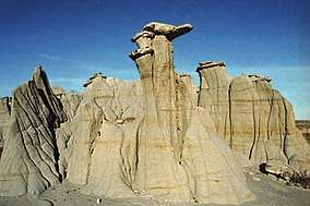 Hoodoo rock formation | |
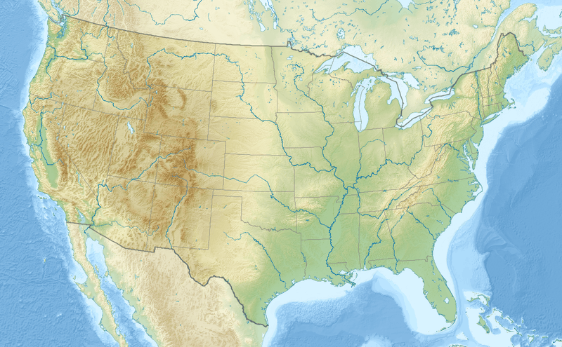 Location in the United States  Location in North Dakota | |
| Location | Billings and McKenzie counties, North Dakota, United States |
| Nearest city | Medora |
| Coordinates | 46°58′N 103°27′W |
| Area | 70,446 acres (285.08 km2)[1] |
| Established | November 10, 1978 |
| Visitors | 749,389 (in 2018)[2] |
| Governing body | National Park Service |
| Website | Official website |
The park's larger South Unit lies alongside Interstate 94 near Medora, North Dakota. The smaller North Unit is situated about 80 mi (130 km) north of the South Unit, on U.S. Route 85, just south of Watford City, North Dakota. Roosevelt's Elkhorn Ranch is located between the North and South units, approximately 20 mi (32 km) west of US 85 and Fairfield, North Dakota. The Little Missouri River flows through all three units of the park. The Maah Daah Hey Trail connects all three units.
The park received 749,389 recreational visitors in 2018.[2] It is the only American national park named directly after a single person.
History
Roosevelt connection
Roosevelt first came to the North Dakota badlands to hunt bison in September 1883. During that first short trip, he got his bison and fell in love with the rugged lifestyle and the "perfect freedom" of the West. He invested $14,000 in the Maltese Cross Ranch, which was already being managed by Sylvane Ferris and Bill Merrifield seven miles south of Medora. That winter, Ferris and Merrifield built the Maltese Cross Cabin. After the death of both his wife and his mother on February 14, 1884, Teddy Roosevelt returned to his North Dakota ranch seeking solitude and time to heal. That summer, he started his second ranch, the Elkhorn Ranch, 35 miles north of Medora, which he hired two Maine woodsmen, Bill Sewall and Wilmot Dow, to operate. Teddy Roosevelt took great interest in his ranches and in hunting in the West, detailing his experiences in pieces published in eastern newspapers and magazines. He wrote three major works on his life in the West: Ranch Life and the Hunting Trail, Hunting Trips of a Ranchman and The Wilderness Hunter. His adventures in "the strenuous life" outdoors and the loss of his cattle in the starvation winter in 1886–1887 were influential in Theodore Roosevelt's pursuit of conservation policies as President of the United States (1901–1909).
Park development
Following Theodore Roosevelt's death in 1919, the Little Missouri Badlands were explored to determine possible park sites. Civilian Conservation Corps camps were established in both of the future park units from 1934 to 1941, and they developed roads and other structures in use today. The area was designated the Roosevelt Recreation Demonstration Area in 1935. In 1946 it was transferred to the United States Fish and Wildlife Service as the Theodore Roosevelt National Wildlife Refuge. After a five-year campaign by North Dakota representative William Lemke, President Truman established the South Unit of Theodore Roosevelt National Memorial Park on April 25, 1947, the only National Memorial Park ever established; the North Unit was added by act of Congress in June, 1948. In 1978, in addition to boundary adjustments and the establishment of 29,920 acres (121.1 km2) of the Theodore Roosevelt Wilderness, the park's designation was changed to Theodore Roosevelt National Park.
Attractions
Both main units of the park have scenic drives, approximately 100 miles of foot and horse trails, wildlife viewing, and opportunities for back country hiking and camping. There are three developed campgrounds: Juniper Campground in the North Unit, Cottonwood Campground in the South Unit, and the Roundup Group Horse Campground in the South Unit.
One of the most popular attractions is wildlife viewing. The park is home to a wide variety of Great Plains wildlife including bison, coyotes, cougars, feral horses, badgers, elk, bighorn sheep, white-tailed deer and mule deer, prairie dogs, and at least 186 species of birds including golden eagles, sharp-tailed grouse, and wild turkeys. Bison may be dangerous and visitors are advised to view them from a distance. Bison, elk, and bighorn sheep have been successfully reintroduced to the park.
The scenery changes constantly in relationship with the seasons. The brown, dormant grass dominates from late summer through the winter, but explodes into green color in the early summer along with hundreds of species of flowering plants. Winter can be a beautiful scene as snow covers the sharp terrain of the badlands and locks the park into what Theodore Roosevelt called "an abode of iron desolation."[4]
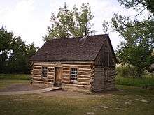
The badlands are very important in Roosevelt's life, and the park memorializes his contributions to the conservation of America's natural resources. A museum at the South Unit Visitor Center provides background on Roosevelt and his ranching days. Roosevelt's Maltese Cross Cabin is open for public viewing year-round at the South Unit Visitor Center.
Roosevelt's Elkhorn Ranch is a separate, remote area of the park, 35 miles north of Medora, accessible by gravel roads. Check with park rangers for road conditions and routes to travel to the site. The foundation of the ranch house and other shops buildings have been preserved, though the other portions of the cabin were removed and re-purposed after Roosevelt vacated the ranch. Threats to the Elkhorn Ranch site include oil development on adjacent lands, particularly visual intrusions and noise pollution from oil facilities and traffic.
The park is popular for back country hiking and horseback riding. Permits for back country camping may be obtained at the South Unit or North Unit Visitor Centers. Over 100 miles of trail make it a fine hiking park, though water and shade are limited along trails. The park units are mostly surrounded by Forest Service grasslands. The area has very dark night skies with excellent star gazing and occasional northern lights.
The entire park has been surrounded with a 7-foot (2.1 m) tall woven wire fence to keep bison and feral horses inside the park and commercial livestock out. Other animals are able to pass over, under, or through the fence in specific locations provided for that purpose.
The town of Medora, at the entrance to the south unit, provides a touristy western experience, with wooden planked sidewalks, old fashioned ice cream parlors, and buggy rides. There are several museums and the Burning Hills Amphitheather with nightly productions of the Medora Musical from early June to early September.
Park officials manage populations of bison, horses, and elk to maintain a balanced ecosystem. Biologists also monitor prairie dog towns, though the park only controls their population in instances where they pose a threat to buildings or human health.
Climate
According to the Köppen climate classification system, Theodore Roosevelt National Park has a Cold semi-arid climate (BSk). According to the United States Department of Agriculture, the Plant Hardiness zone at the North Unit Visitor Center (2008 ft / 612 m) is 3b with an average annual extreme minimum temperature of -30.6 °F (-34.8 °C), and 4a with an average annual extreme minimum temperature of -29.3 °F (-34.1 °C) at the South Unit Visitor Center (2261 ft / 689 m).[5]
| Climate data for North Unit Visitor Center, Theodore Roosevelt National Park. Elev: 2198 ft (670 m) | |||||||||||||
|---|---|---|---|---|---|---|---|---|---|---|---|---|---|
| Month | Jan | Feb | Mar | Apr | May | Jun | Jul | Aug | Sep | Oct | Nov | Dec | Year |
| Average high °F (°C) | 25.2 (−3.8) |
30.7 (−0.7) |
41.9 (5.5) |
57.9 (14.4) |
68.4 (20.2) |
77.1 (25.1) |
85.2 (29.6) |
85.0 (29.4) |
73.3 (22.9) |
58.1 (14.5) |
40.3 (4.6) |
27.9 (−2.3) |
56.0 (13.3) |
| Daily mean °F (°C) | 14.6 (−9.7) |
19.8 (−6.8) |
30.5 (−0.8) |
43.9 (6.6) |
54.6 (12.6) |
63.6 (17.6) |
70.4 (21.3) |
69.5 (20.8) |
58.3 (14.6) |
44.7 (7.1) |
29.7 (−1.3) |
17.5 (−8.1) |
43.2 (6.2) |
| Average low °F (°C) | 4.0 (−15.6) |
8.8 (−12.9) |
19.0 (−7.2) |
29.9 (−1.2) |
40.8 (4.9) |
50.1 (10.1) |
55.6 (13.1) |
54.0 (12.2) |
43.2 (6.2) |
31.3 (−0.4) |
19.1 (−7.2) |
7.1 (−13.8) |
30.3 (−0.9) |
| Average precipitation inches (mm) | 0.39 (9.9) |
0.30 (7.6) |
0.63 (16) |
1.03 (26) |
2.17 (55) |
3.04 (77) |
2.37 (60) |
1.68 (43) |
1.40 (36) |
1.37 (35) |
0.48 (12) |
0.41 (10) |
15.27 (388) |
| Average relative humidity (%) | 74.6 | 73.2 | 65.7 | 52.4 | 53.0 | 57.9 | 54.9 | 50.7 | 51.9 | 57.5 | 68.2 | 75.9 | 61.3 |
| Average dew point °F (°C) | 1.6 (−16.9) |
5.4 (−14.8) |
15.0 (−9.4) |
25.7 (−3.5) |
38.4 (3.6) |
50.8 (10.4) |
56.6 (13.7) |
55.7 (13.2) |
47.5 (8.6) |
34.4 (1.3) |
21.7 (−5.7) |
7.7 (−13.5) |
30.2 (−1.0) |
| Source: PRISM Climate Group[6] | |||||||||||||
| Climate data for South Unit Visitor Center, Theodore Roosevelt National Park. Elev: 2382 ft (726 m) | |||||||||||||
|---|---|---|---|---|---|---|---|---|---|---|---|---|---|
| Month | Jan | Feb | Mar | Apr | May | Jun | Jul | Aug | Sep | Oct | Nov | Dec | Year |
| Average high °F (°C) | 28.0 (−2.2) |
32.7 (0.4) |
43.3 (6.3) |
57.5 (14.2) |
68.0 (20.0) |
77.4 (25.2) |
85.5 (29.7) |
85.7 (29.8) |
73.8 (23.2) |
58.8 (14.9) |
41.8 (5.4) |
30.1 (−1.1) |
57.0 (13.9) |
| Daily mean °F (°C) | 16.9 (−8.4) |
21.2 (−6.0) |
31.3 (−0.4) |
43.6 (6.4) |
54.4 (12.4) |
63.7 (17.6) |
70.5 (21.4) |
69.8 (21.0) |
58.4 (14.7) |
45.0 (7.2) |
30.7 (−0.7) |
18.9 (−7.3) |
43.8 (6.6) |
| Average low °F (°C) | 5.8 (−14.6) |
9.7 (−12.4) |
19.3 (−7.1) |
29.8 (−1.2) |
40.7 (4.8) |
50.1 (10.1) |
55.6 (13.1) |
53.9 (12.2) |
43.0 (6.1) |
31.2 (−0.4) |
19.6 (−6.9) |
7.7 (−13.5) |
30.6 (−0.8) |
| Average precipitation inches (mm) | 0.31 (7.9) |
0.31 (7.9) |
0.67 (17) |
1.15 (29) |
2.15 (55) |
2.81 (71) |
2.27 (58) |
1.34 (34) |
1.32 (34) |
1.14 (29) |
0.50 (13) |
0.31 (7.9) |
14.28 (363) |
| Average relative humidity (%) | 71.6 | 70.8 | 64.2 | 53.0 | 53.8 | 57.9 | 54.1 | 50.1 | 51.3 | 56.8 | 66.0 | 72.8 | 60.2 |
| Average dew point °F (°C) | 9.3 (−12.6) |
13.2 (−10.4) |
20.6 (−6.3) |
27.6 (−2.4) |
38.0 (3.3) |
48.6 (9.2) |
53.1 (11.7) |
50.4 (10.2) |
40.5 (4.7) |
30.6 (−0.8) |
20.7 (−6.3) |
11.6 (−11.3) |
30.4 (−0.9) |
| Source: PRISM Climate Group[6] | |||||||||||||
Ecology
According to the A. W. Kuchler U.S. Potential natural vegetation Types, Theodore Roosevelt National Park has two classifications; a Wheatgrass/Needlegrass (66) vegetation type with a North Mixed grass prairie (18) vegetation form, and a Northern Floodplain (98) vegetation type with a Floodplain Forests (24) vegetation form.[7]
Notes
- "Listing of acreage as of December 31, 2011". Land Resource Division, National Park Service. Retrieved 2012-05-13.
- "NPS Annual Recreation Visits Report". National Park Service. Retrieved 2019-03-11.
- "Theodore Roosevelt National Park North Unit Scenic Byway". Archived from the original on 2012-05-08. Retrieved 2012-05-13.
- Roosevelt, Theodore (1888). Ranch Life and the Hunting Trail. New York: The Century Co. p. 73.
- "USDA Interactive Plant Hardiness Map". United States Department of Agriculture. Retrieved 2019-07-19.
- "PRISM Climate Group, Oregon State University". www.prism.oregonstate.edu. Retrieved July 19, 2019.
- "U.S. Potential Natural Vegetation, Original Kuchler Types, v2.0 (Spatially Adjusted to Correct Geometric Distortions)". Data Basin. Retrieved 2019-07-19.
External links
| Wikimedia Commons has media related to: |
| Wikivoyage has a travel guide for Theodore Roosevelt National Park. |
- Official website

- "Writings of Theodore Roosevelt", broadcast from Theodore Roosevelt National Park from C-SPAN's American Writers
- U.S. Geological Survey Geographic Names Information System: Theodore Roosevelt National Memorial Park
| Presidency |
|
|---|---|
| Other events |
|
| Life and homes |
|
| Writings and speeches |
|
| Elections |
|
| Legacy |
|
| Popular culture |
|
| Related |
|
| Family |
|
| |
National parks of the United States | ||
|---|---|---|
| ||
List of national parks of the United States (by elevation) | ||