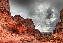
Arches National Park
Arches National Park is a national park in eastern Utah, United States. The park is adjacent to the Colorado River, 4 miles (6 km) north of Moab, Utah. More than 2,000 natural sandstone arches are located in the park, including the well-known Delicate Arch, as well as a variety of unique geological resources and formations. The park contains the highest density of natural arches in the world.[3][4]
| Arches National Park | |
|---|---|
IUCN category II (national park) | |
 Delicate Arch with background of La Sal Mountains | |
 Location in the United States 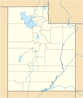 Location in Utah | |
| Location | Grand County, Utah, United States |
| Nearest city | Moab, Utah |
| Coordinates | 38.68333°N 109.56667°W |
| Area | 76,679 acres (119.811 sq mi; 31,031 ha; 310.31 km2)[1] |
| Established | April 12, 1929, as a national monument |
| Visitors | 1,663,557 (in 2018)[2] |
| Governing body | National Park Service |
| Website | Official website |
The park consists of 76,679 acres (119.811 sq mi; 31,031 ha; 310.31 km2) of high desert located on the Colorado Plateau.[5] The highest elevation in the park is 5,653 feet (1,723 m) at Elephant Butte, and the lowest elevation is 4,085 feet (1,245 m) at the visitor center. The park receives an average of less than 10 inches (250 mm) of rain annually.
Administered by the National Park Service, the area was originally named a national monument on April 12, 1929, and was redesignated as a national park on November 12, 1971.[6] The park received more than 1.6 million visitors in 2018.[2]
Geology
The national park lies above an underground evaporite layer or salt bed, which is the main cause of the formation of the arches, spires, balanced rocks, sandstone fins, and eroded monoliths in the area. This salt bed is thousands of feet thick in places, and was deposited in the Paradox Basin of the Colorado Plateau some 300 million years ago (Mya) when a sea flowed into the region and eventually evaporated. Over millions of years, the salt bed was covered with debris eroded from the Uncompahgre Uplift to the northeast. During the Early Jurassic (about 210 Mya), desert conditions prevailed in the region and the vast Navajo Sandstone was deposited. An additional sequence of stream-laid and windblown sediments, the Entrada Sandstone (about 140 Mya), was deposited on top of the Navajo. Over 5,000 feet (1,500 m) of younger sediments were deposited and have been mostly eroded away. Remnants of the cover exist in the area including exposures of the Cretaceous Mancos Shale. The arches of the area are developed mostly within the Entrada formation.[7]
The weight of this cover caused the salt bed below it to liquefy and thrust up layers of rock into salt domes. The evaporites of the area formed more unusual "salt anticlines" or linear regions of uplift.[7] Faulting occurred and whole sections of rock subsided into the areas between the domes. In some places, they turned almost on edge. The result of one such 2,500-foot (760 m) displacement, the Moab Fault, is seen from the visitor center.
As this subsurface movement of salt shaped the landscape, erosion removed the younger rock layers from the surface. Except for isolated remnants, the major formations visible in the park today are the salmon-colored Entrada Sandstone, in which most of the arches form, and the buff-colored Navajo Sandstone. These are visible in layer-cake fashion throughout most of the park. Over time, water seeped into the surface cracks, joints, and folds of these layers. Ice formed in the fissures, expanding and putting pressure on surrounding rock, breaking off bits and pieces. Winds later cleaned out the loose particles. A series of free-standing fins remained. Wind and water attacked these fins until, in some, the cementing material gave way and chunks of rock tumbled out. Many damaged fins collapsed. Others, with the right degree of hardness and balance, survived despite their missing sections. These became the famous arches.
Although the park's terrain may appear rugged and durable, it is extremely fragile. More than 1 million visitors each year threaten the fragile high-desert ecosystem.[8] The problem lies within the soil's crust, which is composed of cyanobacteria, algae, fungi, and lichens that grow in the dusty parts of the park. Factors that make Arches National Park sensitive to visitor damage include being a semiarid region, the scarce, unpredictable rainfall, lack of deep freezing, and lack of plant litter, which results in soils that have both a low resistance to, and slow recovery from, compressional forces such as foot traffic. Methods of indicating effects on the soil are cytophobic soil crust index, measuring of water infiltration, and t-tests that are used to compare the values from the undisturbed and disturbed areas.[9]
Climate
According to the Köppen climate classification system, Arches Visitor Center has a cold semi-arid climate (BSk).
| Climate data for Arches National Park Headquarters (1981–2015 normals) | |||||||||||||
|---|---|---|---|---|---|---|---|---|---|---|---|---|---|
| Month | Jan | Feb | Mar | Apr | May | Jun | Jul | Aug | Sep | Oct | Nov | Dec | Year |
| Average high °F (°C) | 44 (7) |
52 (11) |
64 (18) |
71 (22) |
82 (28) |
93 (34) |
100 (38) |
97 (36) |
88 (31) |
74 (23) |
56 (13) |
45 (7) |
71.4 (21.9) |
| Average low °F (°C) | 22 (−6) |
28 (−2) |
35 (2) |
42 (6) |
51 (11) |
60 (16) |
67 (19) |
66 (19) |
55 (13) |
42 (6) |
30 (−1) |
23 (−5) |
44.8 (7.1) |
| Average precipitation inches (mm) | 0.58 (15) |
0.50 (13) |
0.78 (20) |
0.74 (19) |
0.68 (17) |
0.44 (11) |
0.83 (21) |
0.96 (24) |
0.84 (21) |
1.24 (31) |
0.60 (15) |
0.55 (14) |
8.74 (221) |
| Average snowfall inches (cm) | 1.9 (4.8) |
.9 (2.3) |
.7 (1.8) |
0 (0) |
0 (0) |
0 (0) |
0 (0) |
0 (0) |
0 (0) |
0 (0) |
.6 (1.5) |
2.5 (6.4) |
6.6 (16.8) |
| Average precipitation days (≥ 0.01 in) | 4.0 | 4.4 | 6.1 | 5.3 | 4.6 | 3.1 | 5.2 | 6.6 | 5.2 | 5.5 | 4.5 | 3.9 | 58.4 |
| Average snowy days (≥ 0.1 in) | 1.3 | .8 | .4 | 0 | 0 | 0 | 0 | 0 | 0 | 0 | .4 | 1.4 | 4.3 |
| Source: NOAA (extremes 1893–present)[10] | |||||||||||||
| Mean daily daylight hours for Arches National Park | |||||||||||||
|---|---|---|---|---|---|---|---|---|---|---|---|---|---|
| Month | Jan | Feb | Mar | Apr | May | Jun | Jul | Aug | Sep | Oct | Nov | Dec | Year |
| Mean daily daylight hours | 10.0 | 10.5 | 12.0 | 13.0 | 14.0 | 15.0 | 14.5 | 13.5 | 12.5 | 11.5 | 10.0 | 9.5 | 12.2 |
| Source: Weather Atlas [11] | |||||||||||||
| Climate data for Moab, Utah (1981–2010 normals) | |||||||||||||
|---|---|---|---|---|---|---|---|---|---|---|---|---|---|
| Month | Jan | Feb | Mar | Apr | May | Jun | Jul | Aug | Sep | Oct | Nov | Dec | Year |
| Record high °F (°C) | 67 (19) |
78 (26) |
88 (31) |
96 (36) |
109 (43) |
113 (45) |
114 (46) |
110 (43) |
108 (42) |
97 (36) |
82 (28) |
67 (19) |
114 (46) |
| Average high °F (°C) | 43.3 (6.3) |
51.2 (10.7) |
63.2 (17.3) |
72.4 (22.4) |
82.9 (28.3) |
93.1 (33.9) |
98.9 (37.2) |
96.0 (35.6) |
87.1 (30.6) |
73.2 (22.9) |
56.0 (13.3) |
44.2 (6.8) |
71.8 (22.1) |
| Average low °F (°C) | 19.8 (−6.8) |
26.1 (−3.3) |
34.5 (1.4) |
41.9 (5.5) |
49.7 (9.8) |
57.8 (14.3) |
64.5 (18.1) |
63.1 (17.3) |
53.1 (11.7) |
40.7 (4.8) |
29.6 (−1.3) |
21.3 (−5.9) |
41.8 (5.4) |
| Record low °F (°C) | −24 (−31) |
−13 (−25) |
8 (−13) |
15 (−9) |
27 (−3) |
36 (2) |
43 (6) |
40 (4) |
28 (−2) |
15 (−9) |
2 (−17) |
−19 (−28) |
−24 (−31) |
| Average precipitation inches (mm) | 0.61 (15) |
0.59 (15) |
0.79 (20) |
0.83 (21) |
0.73 (19) |
0.43 (11) |
0.99 (25) |
0.97 (25) |
0.87 (22) |
1.17 (30) |
0.74 (19) |
0.69 (18) |
9.41 (240) |
| Average snowfall inches (cm) | 2.1 (5.3) |
1.0 (2.5) |
.4 (1.0) |
0 (0) |
0 (0) |
0 (0) |
0 (0) |
0 (0) |
0 (0) |
.1 (0.25) |
.6 (1.5) |
2.8 (7.1) |
6.9 (18) |
| Average precipitation days (≥ 0.01 in) | 5.0 | 5.6 | 6.0 | 5.8 | 4.8 | 2.9 | 4.8 | 6.4 | 5.7 | 5.6 | 4.7 | 5.1 | 62.3 |
| Average snowy days (≥ 0.1 in) | 1.2 | .7 | .2 | 0 | 0 | 0 | 0 | 0 | 0 | 0 | .3 | 1.5 | 3.9 |
| Source: NOAA (extremes 1893–present)[10] | |||||||||||||
History
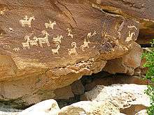
Humans have occupied the region since the last ice age 10,000 years ago. Fremont people and ancestral Puebloans lived in the area until about 700 years ago. Spanish missionaries encountered Ute and Paiute tribes in the area when they first came through in 1775, but the first European-Americans to attempt settlement in the area were the Mormon Elk Mountain Mission in 1855, who soon abandoned the area. Ranchers, farmers, and prospectors later settled Moab in the neighboring Riverine Valley in the 1880s. Word of the beauty of the surrounding rock formations spread beyond the settlement as a possible tourist destination.
The Arches area was first brought to the attention of the National Park Service by Frank A. Wadleigh, passenger traffic manager of the Denver and Rio Grande Western Railroad. Wadleigh, accompanied by railroad photographer George L. Beam, visited the area in September 1923 at the invitation of Alexander Ringhoffer, a Hungarian-born prospector living in Salt Valley. Ringhoffer had written to the railroad in an effort to interest them in the tourist potential of a scenic area he had discovered the previous year with his two sons and a son-in-law, which he called the Devils Garden (known today as the Klondike Bluffs). Wadleigh was impressed by what Ringhoffer showed him, and suggested to Park Service director Stephen T. Mather that the area be made a national monument.
The following year, additional support for the monument idea came from Laurence Gould, a University of Michigan graduate student (and future polar explorer) studying the geology of the nearby La Sal Mountains, who was shown the scenic area by local physician Dr. J. W. "Doc" Williams.
.jpg)
A succession of government investigators examined the area, in part due to confusion as to the precise location. In the process, the name Devils Garden was transposed to an area on the opposite side of Salt Valley that includes Landscape Arch, the longest arch in the park. Ringhoffer's original discovery was omitted, while another area nearby, known locally as the Windows, was included. Designation of the area as a national monument was supported by the Park Service from 1926, but was resisted by President Calvin Coolidge's Interior Secretary, Hubert Work. Finally, in April 1929, shortly after his inauguration, President Herbert Hoover signed a presidential proclamation creating Arches National Monument, consisting of two comparatively small, disconnected sections. The purpose of the reservation under the 1906 Antiquities Act was to protect the arches, spires, balanced rocks, and other sandstone formations for their scientific and educational value. The name Arches was suggested by Frank Pinkely, superintendent of the Park Service's southwestern national monuments, following a visit to the Windows section in 1925.
In late 1938, President Franklin D. Roosevelt signed a proclamation that enlarged Arches to protect additional scenic features and permit development of facilities to promote tourism. A small adjustment was made by President Dwight Eisenhower in 1960 to accommodate a new road alignment.
In early 1969, just before leaving office, President Lyndon B. Johnson signed a proclamation substantially enlarging Arches. Two years later, President Richard Nixon signed legislation enacted by Congress, which significantly reduced the total area enclosed, but changed its status to a national park.
Recreational activities
Climbing Balanced Rock or any named or unnamed arch in Arches National Park with an opening larger than 3 ft (0.9 m) is banned by park regulations. Climbing on other features in the park is allowed, but regulated; in addition, slacklining and BASE jumping are banned parkwide.[12]
Climbing on named arches within the park had long been banned by park regulations, but following Dean Potter's successful free climb on Delicate Arch in May 2006, the wording of the regulations was deemed unenforceable by the park attorney. In response, the park revised its regulations later that month,[13] eventually imposing the current ban on arch climbing in 2014.[14]
Approved recreational activities include auto touring,[15] hiking,[16] bicycling,[17] camping at the Devils Garden campground,[18] backpacking,[19] canyoneering,[20] and rock climbing,[21] with permits required for the last three activities. Guided commercial tours[22] and ranger programs are also available.[23]
Astronomy is also popular in the park due to its dark skies, despite the increasing light pollution from towns such as Moab.[24][25]
Publicity
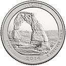
Delicate Arch is the subject of the third 2014 quarter of the U.S. Mint's America the Beautiful Quarters program commemorating national parks and historic sites. The Arches quarter had the highest production of the five 2014 national park quarters, with more than 465 million minted.[26]
American writer Edward Abbey was a park ranger at Arches National Monument in 1956 and 1957, where he kept journals that became his book Desert Solitaire.[27] The success of Abbey's book, as well as interest in adventure travel, has drawn many hikers, mountain bikers, and off-pavement driving enthusiasts to the area. Permitted activities within the park include camping, hiking along designated trails, backpacking, canyoneering, rock climbing, bicycling, and driving along existing roads, both paved and unpaved.[28] The Hayduke Trail, an 812-mile (1,307 km) backpacking route named after one of Edward Abbey's characters, begins in the park.[29]
Plants and animals
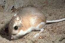
An abundance of wildlife occurs in Arches. The list includes: spadefoot toad, antelope squirrel, scrub jay, peregrine falcon, many kinds of sparrows, red fox, desert bighorn sheep, kangaroo rat, mule deer, cougar, midget faded rattlesnake, yucca moth, western rattlesnake, and the collared lizard.[30]
Plants also dominate the landscape in the park. The list of plants includes: prickly pear cactus, Indian ricegrass, bunch grasses, cheatgrass, lichen, moss, liverworts, Utah juniper, Mormon tea, blackbrush, cliffrose, four-winged saltbrush, pinyon pine, evening primrose, sand verbena, yucca, and sacred datura.[31]
Biological soil crust consisting of cyanobacteria, lichen, mosses, green algae, and microfungi is found throughout southeastern Utah. The fibrous growths help keep soil particles together, creating a layer that is more resistant to erosion. The living soil layer readily absorbs and stores water, allowing more complex forms of plant life to grow in places with low precipitation levels.[32]
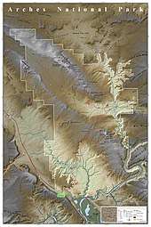
Features
Among the notable features of the park are:
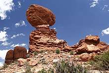
- Balanced Rock – a large balancing rock, the size of three school buses
- Courthouse Towers – a collection of tall stone columns
- Dark Angel – a free-standing 150-foot-tall (46 m) sandstone pillar at the end of the Devils Garden Trail
- Delicate Arch – a lone-standing arch which has become a symbol of Utah and the most recognized arch in the park
- Devils Garden – many arches and columns scattered along a ridge
- Double Arch – two arches that share a common end
- Fiery Furnace – an area of maze-like narrow passages and tall rock columns (see biblical reference, Book of Daniel, chapter 3)
- Landscape Arch – a very thin and long arch in the Devils Garden with a span of 290 feet (88 m) (the longest arch in the park)
- Petrified Dunes – petrified remnants of sand dunes blown from the ancient lakes that covered the area
- Wall Arch – located along the popular Devils Garden Trail; collapsed sometime on August 4/5, 2008[33][34]
Gallery
 Double Arch
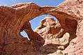
.jpg) The Windows
The Windows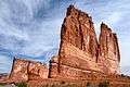 The Organ, a sandstone tower in the Courthouse Towers area
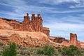 The Three Gossips
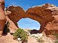 Broken Arch
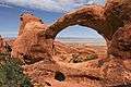 Double O Arch
 Navajo Arch
 Skyline Arch
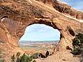 Partition Arch
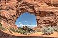 Pine Tree Arch
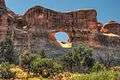 Tunnel Arch
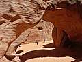 Sand Dune Arch
See also
- List of national parks of the United States
- National Register of Historic Places listings in Arches National Park
- Natural Bridges National Monument - three natural bridges formed by flowing water
- Rainbow Bridge National Monument - the largest natural bridge in the Western Hemisphere
References
- "Listing of acreage as of December 31, 2011". Land Resource Division, National Park Service. Retrieved 2012-03-05.
- "NPS Annual Recreation Visits Report". National Park Service. Retrieved 2019-03-06.
- Rowan, James. "Arches National Park". YC.edu. Yavasai College. Retrieved 7 September 2016.
- "Nature". NPS.gov. National Park Service. Retrieved 7 September 2016.
- "Arches National Park". nationalgeographic.com. Retrieved 2 October 2013.
- "Arches National Park". The National Parks: Index 2009–2011. National Park Service. Archived from the original on 29 June 2011. Retrieved 2011-06-08.
- Kiver, Eugene P.; Harris, David V. (1999). Geology of U.S. parklands (5th ed.). New York [u.a.]: J. Wiley. pp. 503–515. ISBN 0-471-33218-6.
- National Geographic (2007). Guide to the national parks of the United States (5th ed.). Washington, D.C.: National Geographic Society. pp. 152–157. ISBN 978-1435129504.
- Belnap, J (July 1998). "Choosing Indicators of Natural Resource Condition: a Case Study in Arches National Park, Utah, USA". Environmental Management. 22 (4): 635–642. doi:10.1007/s002679900135.
- "NowData - NOAA Online Weather Data". National Oceanic and Atmospheric Administration. Retrieved 2013-07-03.
- "Arches National Park, Utah, USA - Monthly weather forecast and Climate data". Weather Atlas. Retrieved 29 June 2019.
- "Rock Climbing - Arches National Park". NPS.gov. National Park Service. December 18, 2017. Retrieved January 13, 2018.
- "Arches announces climbing closures". May 9, 2006. Retrieved 2011-06-08.
All rock climbing or similar activities on any arch or natural bridge named on the United States Geological Survey 7.5 minute topographical maps covering Arches National Park are prohibited.
- Cannon, Kate (September 29, 2014). "Activities on Arches Determination - Arches National Park". NPS.gov. National Park Service. Retrieved January 13, 2018.
In accordance with the provisions of 36 CFR 1.5, and the requirements of NPS Management Policies 2006 Sections 1.5 and 8.2, it is my professional judgment that it is necessary to prohibit climbing, scrambling, or walking upon, wrapping webbing or rope around, or rappelling from any arch with an opening greater than 3 feet in Arches and Canyonlands National Parks, except for Washer Woman Arch in the Island in the Sky District of Canyonlands.
- "Auto Touring". nps.gov. National Park Service. Retrieved June 29, 2019.
- "Hiking". nps.gov. National Park Service. Retrieved June 29, 2019.
- "Biking". nps.gov. National Park Service. Retrieved June 29, 2019.
- "Camping". nps.gov. National Park Service. Retrieved June 29, 2019.
- "Backpacking". nps.gov. National Park Service. Retrieved June 29, 2019.
- "Canyoneering". nps.gov. National Park Service. Retrieved June 29, 2019.
- "Rock Climbing". nps.gov. National Park Service. Retrieved June 29, 2019.
- "Commercial Tours". nps.gov. National Park Service. Retrieved June 29, 2019.
- "Ranger-led Programs". nps.gov. National Park Service. Retrieved June 29, 2019.
- "Arches National Park – Lightscape/Night Sky". Archived from the original on 1 December 2010. Retrieved 2011-01-04.
- "Arches National Park – Dark Sky, USA". Retrieved 2011-01-04.
- "Mintage Totals – 2014". usmint.gov.
- Scheese, Don (1998). "Desert Solitaire: Counter-Friction to the Machine in the Garden". In Glotfelty, Cheryl; Fromm, Harold (eds.). The ecocriticism reader: landmarks in literary ecology. University of Georgia Press. p. 305. ISBN 978-0-8203-1781-6.
- "Things To Do". nps.gov. National Park Service. Retrieved June 29, 2019.
- Mitchell, Joe; Coronella, Mike (2005). The Hayduke Trail: A Guide to the Backcountry. The University of Utah Press. p. 1. ISBN 0874808138.
- "Animals - Arches National Park (U.S. National Park Service)". Nps.gov. 2013-11-25. Retrieved 2013-11-30.
- "Plants - Arches National Park (U.S. National Park Service)". Nps.gov. 2013-11-25. Retrieved 2013-11-30.
- "Biological Soil Crust of Southeast Utah". nps.gov. National Park Service. n.d. Retrieved 2018-04-19.
- "Wall Collapses". Arches National Park: National Park Service. August 8, 2008.
- Stark, Mike (August 10, 2008). "Iconic Stone Arch Collapses in Southern Utah Park". Washington Post.
Further reading
- Doelling, Hellmut H. (2000). Anderson, P.B.; Sprinkel, D.A (eds.). "Geologic road and trail guides to Arches National Park" (PDF). Geologic Road, Trail, and Lake Guides to Utah's Parks and Monuments. Utah Geological Association. Retrieved 2 May 2018.
External links
- Official website
- Utah Office of Tourism page on Arches National Park
- Historic American Engineering Record (HAER) No. UT-70, "Arches National Park Main Entrance Road, Beginning at U.S. Highway 191, approximately 6 miles north of Moab, Moab, Grand County, UT", 7 photos, 3 color transparencies, 23 data pages, 2 photo caption pages
- HAER No. UT-70-A, "Arches National Park Main Entrance Road, Moab Canyon Wash Culvert, Spanning Moab Canyon wash at Main Entrance Road, Moab, Grand County, UT", 3 photos, 6 data pages, 1 photo caption page
National parks of the United States | ||
|---|---|---|
| ||
List of national parks of the United States (by elevation) | ||
Salt Lake City (capital) | |||||||||||||
| Topics |  | ||||||||||||
| Society |
| ||||||||||||
| Regions |
| ||||||||||||
| Largest cities |
| ||||||||||||
| Counties |
| ||||||||||||
| Attractions |
| ||||||||||||
Colorado River system | |||||||||
|---|---|---|---|---|---|---|---|---|---|
| Jurisdictions |
|     | |||||||
| Canyons |
| ||||||||
| Natural features |
| ||||||||
| Tributaries |
| ||||||||
| Engineering |
| ||||||||
| Designated areas |
| ||||||||
| Related topics |
| ||||||||
| Authority control |
|
|---|