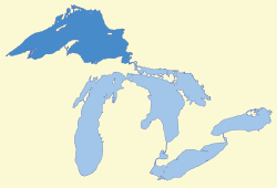
Lake Superior
Lake Superior, the largest of the Great Lakes of North America, is also the world's largest freshwater lake by surface area, and the third largest freshwater lake by volume. It is shared by the Canadian province of Ontario to the north, the U.S. state of Minnesota to the west, and Wisconsin and the Upper Peninsula of Michigan to the south.[12] The farthest north and west of the Great Lakes chain, Superior has the highest elevation of all five great lakes and drains into the St. Mary's River.
| Lake Superior | |
|---|---|
 Lake Superior and the other Great Lakes | |
 | |
| Location | North America |
| Group | Great Lakes |
| Coordinates | 47.7°N 87.5°W |
| Lake type | Glacial |
| Native name | ᑭᑦᒉᐁ-ᑲᒣᐁ, Gitchi-Gami (Ojibwe) |
| Primary inflows | Nipigon, St. Louis, Pigeon, Pic, White, Michipicoten, Kaministiquia, Ontonagon, Tahquamenon Rivers |
| Primary outflows | St. Marys River |
| Catchment area | 49,300 sq mi (128,000 km2)[7] |
| Basin countries | Canada United States |
| Max. length | 350 mi (560 km)[8] |
| Max. width | 160 mi (260 km)[8] |
| Surface area | 31,700 sq mi (82,000 km2)[7] |
| Average depth | 483 ft (147 m)[7] |
| Max. depth | 1,333 ft (406 m)[7][9] |
| Water volume | 2,900 cu mi (12,000 km3)[7] |
| Residence time | 191 years |
| Shore length1 | 1,729 mi (2,783 km) plus 997 mi (1,605 km) for islands[10] |
| Surface elevation | 601.71 ft (183 m) (2013 average)[11] |
| Islands | Isle Royale, Apostle Islands, Michipicoten Island, Slate Islands |
| Settlements |
|
| 1 Shore length is not a well-defined measure. | |
Name
The Ojibwe name for the lake is gichi-gami (pronounced as gitchi-gami and kitchi-gami in other dialects),[13] meaning "great sea." Henry Wadsworth Longfellow wrote the name as "Gitche Gumee" in The Song of Hiawatha, as did Gordon Lightfoot in his song "The Wreck of the Edmund Fitzgerald." According to other sources, the actual Ojibwe name is Ojibwe Gichigami ("Ojibwe's Great Sea") or Anishinaabe Gichigami ("Anishinaabe's Great Sea").[14] The 1878 dictionary by Father Frederic Baraga, the first one written for the Ojibway language, gives the Ojibwe name as Otchipwe-kitchi-gami (reflecting Ojibwe Gichigami).[13]
The first French explorers approaching the great inland sea by way of the Ottawa River and Lake Huron during the 17th century referred to their discovery as le lac supérieur. Properly translated, the expression means "Upper Lake"—that is, the lake above Lake Huron. The lake was also called Lac Tracy (named for Alexandre de Prouville de Tracy) by 17th century Jesuit missionaries.[15] The British, upon taking control of the region from the French in the 1760s following the French and Indian War, anglicized the lake's name to Superior, "on account of its being superior in magnitude to any of the lakes on that vast continent".[16]
Hydrography
Lake Superior empties into Lake Huron via the St. Marys River and the Soo Locks. Lake Superior is the largest freshwater lake in the world in area and the third largest in volume, behind Lake Baikal in Siberia and Lake Tanganyika in East Africa. The Caspian Sea, while larger than Lake Superior in both surface area and volume, is brackish; though presently isolated, prehistorically the Caspian has been repeatedly connected to and then isolated from the Mediterranean via the Black Sea.
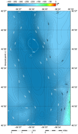
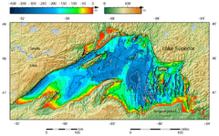
Lake Superior has a surface area of 31,700 square miles (82,103 km2),[7] which is approximately the size of South Carolina or Austria. It has a maximum length of 350 statute miles (560 km; 300 nmi) and maximum breadth of 160 statute miles (257 km; 139 nmi).[8] Its average depth is 80.5 fathoms (483 ft; 147 m) with a maximum depth of 222.17 fathoms (1,333 ft; 406 m).[7][8][9] Lake Superior contains 2,900 cubic miles (12,100 km³) of water.[7] There is enough water in Lake Superior to cover the entire land mass of North and South America to a depth of 30 centimetres (12 in).[lower-alpha 1] The shoreline of the lake stretches 2,726 miles (4,387 km) (including islands).[7]
American limnologist J. Val Klump was the first person to reach the lowest depth of Lake Superior on July 30, 1985, as part of a scientific expedition, which at 122 fathoms 1 foot (733 ft or 223 m) below sea level is the second-lowest spot in the continental interior of the United States and the third-lowest spot in the interior of the North American continent after Iliamna Lake in Alaska (942 feet [287 m] below sea level) and Great Slave Lake in the Northwest Territories of Canada at (1,503 feet [458 m] below sea level). (Though Crater Lake is the deepest lake in the United States and deeper than Lake Superior, Crater Lake's elevation is higher and consequently its deepest point is 4,229 feet (1,289 m) above sea level.)
While the temperature of the surface of Lake Superior varies seasonally, the temperature below 110 fathoms (660 ft; 200 m) is an almost constant 39 °F (4 °C). This variation in temperature makes the lake seasonally stratigraphic. Twice per year, however, the water column reaches a uniform temperature of 39 °F (4 °C) from top to bottom, and the lake waters thoroughly mix. This feature makes the lake dimictic. Because of its volume, Lake Superior has a retention time of 191 years.[17][18]
Annual storms on Lake Superior regularly feature wave heights of over 20 feet (6 m).[19] Waves well over 30 feet (9 m) have been recorded.[20]
Tributaries and outlet
Lake Superior is fed by more than 200 rivers, including the Nipigon River, the St. Louis River, the Pigeon River, the Pic River, the White River, the Michipicoten River, the Bois Brule River and the Kaministiquia River. Lake Superior drains into Lake Huron via the St. Marys River. There are rapids at the river's upper (Lake Superior) end, where the river bed has a relatively steep gradient. The Soo Locks enable ships to bypass the rapids and to overcome the 25-foot (8 m) height difference between Lakes Superior and Huron.
Water levels

.jpg)
The lake's average surface elevation is 600 feet (183 m)[8][17] above sea level. Until approximately 1887, the natural hydraulic conveyance through the St. Marys River rapids determined the outflow from Lake Superior. By 1921, development in support of transportation and hydroelectric power resulted in gates, locks, power canals and other control structures completely spanning St. Marys rapids. The regulating structure is known as the Compensating Works and is operated according to a regulation plan known as Plan 1977-A. Water levels, including diversions of water from the Hudson Bay watershed, are regulated by the International Lake Superior Board of Control, which was established in 1914 by the International Joint Commission.
Lake Superior's water level was at a new record low in September 2007, slightly less than the previous record low in 1926.[21] Water levels recovered within a few days.[22]
Historic high water The lake's water level fluctuates from month to month, with the highest lake levels in October and November. The normal high-water mark is 1.17 feet (0.36 m) above datum (601.1 ft or 183.2 m). In the summer of 1985, Lake Superior reached its highest recorded level at 2.33 feet (0.71 m) above datum.[23] The winter of 1986 set new high-water records through the winter and spring months (January to June), ranging from 1.33 feet (0.41 m) to 1.833 feet (0.559 m) above Chart Datum.[23]
Historic low water The lake's lowest levels occur in March and April. The normal low-water mark is 0.33 feet (0.10 m) below datum (601.1 ft or 183.2 m). In the winter of 1926 Lake Superior reached its lowest recorded level at 1.58 feet (0.48 m) below datum.[23] Additionally, the entire first half of the year (January to June) included record low months. The low water was a continuation of the dropping lake levels from the previous year, 1925, which set low-water records for October through December. During the nine-month period of October 1925 to June 1926, water levels ranged from 1.58 feet (0.48 m) to 0.33 feet (0.10 m) below Chart Datum.[23] In the summer of 2007 monthly historic lows were set; August at 0.66 feet (0.20 m), September at 0.58 feet (0.18 m).[23]
Climate change
According to a study by professors at the University of Minnesota Duluth, Lake Superior may have warmed faster than its surrounding area.[24] Summer surface temperatures in the lake appeared to have increased by about 4.5 °F (2.5 °C) between 1979 and 2007, compared with an approximately 2.7 °F (1.5 °C) increase in the surrounding average air temperature. The increase in the lake's surface temperature may be related to the decreasing ice cover. Less winter ice cover allows more solar radiation to penetrate and warm the water. If trends continue, Lake Superior, which freezes over completely once every 20 years, could routinely be ice-free by 2040.[25] This would be a significant departure from historical records as, according to Hubert Lamb, Samuel Champlain reported ice along the shores of Lake Superior in June 1608.[26] Warmer temperatures could lead to more snow in the lake effect snow belts along the shores of the lake, especially in the Upper Peninsula of Michigan. Two recent consecutive winters (2013–2014 and 2014–2015) brought unusually high ice coverage to the Great Lakes, and on March 6, 2014, overall ice coverage peaked at 92.5%, the second-highest in recorded history.[27] Lake Superior's ice coverage further beat 2014's record in 2019, reaching 95% coverage.[28]
Geography

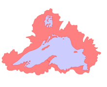
The largest island in Lake Superior is Isle Royale in the state of Michigan. Isle Royale contains several lakes, some of which also contain islands. Other well-known islands include Madeline Island in the state of Wisconsin, Michipicoten Island in the province of Ontario, and Grand Island (the location of the Grand Island National Recreation Area) in the state of Michigan.
The larger cities on Lake Superior include the twin ports of Duluth, Minnesota and Superior, Wisconsin; Thunder Bay, Ontario; Marquette, Michigan; and the twin cities of Sault Ste. Marie, Michigan, and Sault Ste. Marie, Ontario. Duluth-Superior, at the western end of Lake Superior, is the most inland point on the St. Lawrence Seaway and the most inland port in the world.
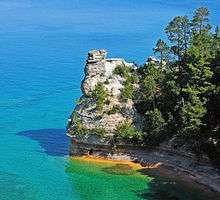
Among the scenic places on the lake are Apostle Islands National Lakeshore, Isle Royale National Park, Porcupine Mountains Wilderness State Park, Pukaskwa National Park, Lake Superior Provincial Park, Grand Island National Recreation Area, Sleeping Giant (Ontario) and Pictured Rocks National Lakeshore.
Great Lakes Circle Tour
The Great Lakes Circle Tour is a designated scenic road system connecting all of the Great Lakes and the St. Lawrence River.[29]
Climate
Lake Superior's size reduces the severity of the seasons of its humid continental climate (more typically seen in locations like Nova Scotia).[30] The water surface's slow reaction to temperature changes, seasonally ranging between 32 and 55 °F (0–13 °C) around 1970,[31] helps to moderate surrounding air temperatures in the summer and winter, and creates lake effect snow in colder months. The hills and mountains that border the lake hold moisture and fog, particularly in the fall.
The lake's surface temperature rose by 4.5 °F (2.5 °C) from 1979 to 2006.[32]

Geology
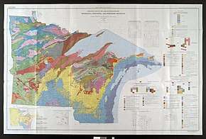
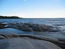
The rocks of Lake Superior's northern shore date back to the early history of the earth. During the Precambrian (between 4.5 billion and 540 million years ago) magma forcing its way to the surface created the intrusive granites of the Canadian Shield.[33] These ancient granites can be seen on the North Shore today. It was during the Penokean orogeny, part of the process that created the Great Lakes Tectonic Zone, that many valuable metals were deposited. The region surrounding the lake has proved to be rich in minerals. Copper, iron, silver, gold and nickel are or were the most frequently mined. Examples include the Hemlo gold mine near Marathon, copper at Point Mamainse, silver at Silver Islet and uranium at Theano Point.
The mountains steadily eroded, depositing layers of sediments that compacted and became limestone, dolomite, taconite and the shale at Kakabeka Falls.
The continent was later riven, creating one of the deepest rifts in the world.[34] The lake lies in this long-extinct Mesoproterozoic rift valley, the Midcontinent Rift. Magma was injected between layers of sedimentary rock, forming diabase sills. This hard diabase protects the layers of sedimentary rock below, forming the flat-topped mesas in the Thunder Bay area.
Amethyst formed in some of the cavities created by the Midcontinent Rift and there are several amethyst mines in the Thunder Bay area.[35]
Lava erupted from the rift and formed the black basalt rock of Michipicoten Island, Black Bay Peninsula, and St. Ignace Island.
During the Wisconsin glaciation 10,000 years ago, ice covered the region at a thickness of 1.25 miles (2 km). The land contours familiar today were carved by the advance and retreat of the ice sheet. The retreat left gravel, sand, clay and boulder deposits. Glacial meltwaters gathered in the Superior basin creating Lake Minong, a precursor to Lake Superior.[36] Without the immense weight of the ice, the land rebounded, and a drainage outlet formed at Sault Ste. Marie, which would become known as St. Mary's River.
History

The first people came to the Lake Superior region 10,000 years ago after the retreat of the glaciers in the last Ice Age. They are known as the Plano, and they used stone-tipped spears to hunt caribou on the northwestern side of Lake Minong.
The next documented people are known as the Shield Archaic (c. 5000–500 BC). Evidence of this culture can be found at the eastern and western ends of the Canadian shore. They used bows and arrows, dugout canoes, fished, hunted, mined copper for tools and weapons, and established trading networks. They are believed to be the direct ancestors of the Ojibwe and Cree.[37]
The Laurel people (c. 500 BC to AD 500) developed seine net fishing, evidence being found at rivers around Superior such as the Pic and Michipicoten.

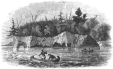
Another culture known as the Terminal Woodland Indians (c. AD 900–1650) has been found. They were Algonkian people who hunted, fished and gathered berries. They used snow shoes, birch bark canoes and conical or domed lodges. At the mouth of the Michipicoten River, nine layers of encampments have been discovered. Most of the Pukaskwa Pits were likely made during this time.[37]
The Anishinaabe, which includes the Ojibwe or Chippewa, have inhabited the Lake Superior region for over five hundred years and were preceded by the Dakota, Fox, Menominee, Nipigon, Noquet and Gros Ventres. They called Lake Superior either Ojibwe Gichigami ("the Ojibwe's Great Sea") or Anishnaabe Gichgamiing ("the Anishinaabe's Great Sea"). After the arrival of Europeans, the Anishinaabe made themselves the middle-men between the French fur traders and other Native peoples. They soon became the dominant Native American nation in the region: they forced out the Sioux and Fox and won a victory against the Iroquois west of Sault Ste. Marie in 1662. By the mid-18th century, the Ojibwe occupied all of Lake Superior's shores.[38]
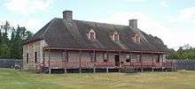
In the 18th century, the fur trade in the region was booming, with the Hudson's Bay Company having a virtual monopoly until 1783, when the North West Company was formed to rival the Hudson's Bay Company. The North West Company built forts on Lake Superior at Grand Portage, Fort William, Nipigon, the Pic River, the Michipicoten River, and Sault Ste. Marie. But by 1821, with competition taking too great a toll on both, the companies merged under the Hudson's Bay Company name.
Many towns around the lake are either current or former mining areas, or engaged in processing or shipping. Today, tourism is another significant industry; the sparsely populated Lake Superior country, with its rugged shorelines and wilderness, attracts tourists and adventurers.
Shipping

Lake Superior has been an important link in the Great Lakes Waterway, providing a route for the transportation of iron ore as well as grain and other mined and manufactured materials. Large cargo vessels called lake freighters, as well as smaller ocean-going freighters, transport these commodities across Lake Superior.
Shipping was slow to arrive at Lake Superior in the 19th century. The first steamboat to run on the lake was the Independence, which didn't appear until 1847, compared to the arrival of the first steamers on the other Great Lakes beginning in 1816.[39][40]
Because of ice, the Lake is closed to shipping from mid-January to late March. Exact dates for the shipping season vary each year,[41] depending on weather conditions that form and break the ice.
Shipwrecks
The southern shore of Lake Superior between Grand Marais, Michigan, and Whitefish Point is known as the "Graveyard of the Great Lakes" and more ships have been lost around the Whitefish Point area than any other part of Lake Superior.[42] These shipwrecks are now protected by the Whitefish Point Underwater Preserve.
Storms that claimed multiple ships include the Mataafa Storm in 1905 and the Great Lakes Storm of 1913.
Wreckage of SS Cyprus—a 420-foot (130 m) ore carrier that sank on October 11, 1907, during a Lake Superior storm in 77 fathoms (460 ft or 140 m) of water—was located in August 2007. All but Charles G. Pitz of Cyprus's 23 crew perished . The ore carrier sank in Lake Superior on her second voyage, while hauling iron ore from Superior, Wisconsin, to Buffalo, New York. Built in Lorain, Ohio, Cyprus was launched August 17, 1907.[43]
In 1918 the last warships to sink in the Great Lakes, French minesweepers Inkerman and Cerisoles, vanished in a Lake Superior storm, perhaps upon striking the uncharted danger of the Superior Shoal in an otherwise deep part of the lake. With 78 crewmembers dead, their sinking marked the largest loss of life on Lake Superior to date.
SS Edmund Fitzgerald was the latest major shipwreck on Lake Superior, sinking 15 nautical miles (28 km; 17 mi) from Whitefish Point in a storm on November 10, 1975. The wreck was immortalized by Gordon Lightfoot in his ballad "The Wreck of the Edmund Fitzgerald". All 29 crew members perished when the ship sank, and no bodies were ever recovered. Edmund Fitzgerald was swallowed up so intensely by Lake Superior that the 729-foot (222 m) ship split in half; her two pieces are approximately 170 feet (52 m) apart in a depth of 91 fathoms 4 feet (550 ft or 170 m).
According to legend, "Lake Superior seldom gives up her dead".[44] This is because of the unusually low temperature of the water, estimated at under 36 °F (2 °C) on average around 1970.[31] Normally, bacteria feeding on a sunken decaying body will generate gas inside the body, causing it to float to the surface after a few days. But Lake Superior's water is cold enough year-round to inhibit bacterial growth, and bodies tend to sink and never resurface.[45] This is alluded to in Lightfoot's "The Wreck of the Edmund Fitzgerald" ballad with the line "The lake, it is said, never gives up her dead". Fitzgerald adventurer Joe MacInnis reported that, in July 1994, explorer Frederick Shannon's Expedition 94 to the wreck of Edmund Fitzgerald discovered and filmed a man's body near the port side of her pilothouse, not far from the open door, "fully clothed, wearing an orange life jacket, and lying face down in the sediment".[46]
Ecology
More than 80 species of fish have been found in Lake Superior. Species native to the lake include: banded killifish, bloater, brook trout, burbot, cisco, lake sturgeon, lake trout, lake whitefish, longnose sucker, muskellunge, northern pike, pumpkinseed, rock bass, round whitefish, smallmouth bass, walleye, white sucker and yellow perch. In addition, many fish species have been either intentionally or accidentally introduced to Lake Superior: Atlantic salmon, brown trout, carp, chinook salmon, coho salmon, freshwater drum, pink salmon, rainbow smelt, rainbow trout, round goby, ruffe, sea lamprey and white perch.[47][48]
Lake Superior has fewer dissolved nutrients relative to its water volume than the other Great Lakes and so is less productive in terms of fish populations and is an oligotrophic lake. This is a result of the underdeveloped soils found in its relatively small watershed.[17] It is also a reflection of relatively small human population and small amount of agriculture in its watershed. However, nitrate concentrations in the lake have been continuously rising for more than a century. They are still much lower than levels considered dangerous to human health; but this steady, long-term rise is an unusual record of environmental nitrogen buildup. It may relate to anthropogenic alternations to the regional nitrogen cycle, but researchers are still unsure of the causes of this change to the lake's ecology.[49]
As for other Great Lakes fish, populations have also been affected by the accidental or intentional introduction of foreign species such as the sea lamprey and Eurasian ruffe. Accidental introductions have occurred in part by the removal of natural barriers to navigation between the Great Lakes. Overfishing has also been a factor in the decline of fish populations.[12]
See also
- List of lakes in Ontario
- North Shore of Lake Superior
- South Shore of Lake Superior
General
- Great Lakes
- Great Lakes Areas of Concern
- Great Lakes census statistical areas
- Great Lakes Commission
- Great Recycling and Northern Development Canal
- Great Lakes Storm of 1913
- International Boundary Waters Treaty
- List of cities along the Great Lakes
- Seiche
- Shipwrecks of the 1913 Great Lakes storm
- Sixty Years' War for control of the Great Lakes
- Third Coast
Notes
- North America (2.47×10⁷ km²) and South America (1.78×10⁷ km²) combined cover 4.26×10⁷ km². Lake Superior's volume (1.20×10⁴ km³) over 4.26×10⁷ km² gives a depth of 0.282 m.
References
- National Geophysical Data Center (1999). "Bathymetry of Lake Superior". National Oceanic and Atmospheric Administration. Retrieved March 23, 2015.
(the general reference to NGDC because this lake was never published, compilation of Great Lakes Bathymetry at NGDC has been suspended). - National Geophysical Data Center (1999). "Bathymetry of Lake Huron". National Oceanic and Atmospheric Administration. doi:10.7289/V5G15XS5. Retrieved March 23, 2015. (only small portion of this map)
- Hastings, D. & Dunbar, P.K. (1999). "Global Land One-Kilometer Base Elevation (GLOBE) v.1". National Geophysical Data Center. doi:10.7289/V52R3PMS. Retrieved March 16, 2015.
- , Great Lakes Environmental Research Laboratory. "About Our Great Lakes: Tour". National Oceanic and Atmospheric Administration. Archived from the original on May 7, 2017. Retrieved December 15, 2017.
- Wright, H. E., Jr. (1973). Black, Robert Foster; Goldthwait, Richard Parker; Willman, Harold (eds.). "Tunnel Valleys, Glacial Surges, and Subglacial Hydrology of the Superior Lobe, Minnesota". Geological Society of America Memoirs. Boulder, Colorado: Geological Society of America. 136: 251–276. doi:10.1130/MEM136-p251. ISBN 0813711363. Retrieved April 1, 2015.
- Regis, Robert S.; Jennings-Patterson, Carrie; Wattrus, Nigel & Rausch, Deborah (March 24–25, 2003). Relationship of Deep Troughs in the Eastern Lake Superior Basin and Large-Scale Glaciofluvial Landforms in the Central Upper Peninsula of Michigan. North-Central Section 37th Annual Meeting. Kansas City, Missouri: The Geological Society of America. Paper No. 19-10. Archived from the original on March 4, 2016. Retrieved April 1, 2015.
- "Great Lakes: Basic Information: Physical Facts". United States Environmental Protection Agency. May 25, 2011. Archived from the original on October 29, 2010. Retrieved November 9, 2011.
- "Great Lakes Atlas: Factsheet #1". United States Environmental Protection Agency. April 11, 2011. Retrieved November 10, 2011.
- Wright, John W., ed. (2006). The New York Times Almanac (2007 ed.). New York: Penguin Books. p. 64. ISBN 0-14-303820-6.
- "Shorelines of the Great Lakes". Michigan Department of Environmental Quality. Archived from the original on April 5, 2015.
- "Great Lakes Water Levels" (PDF). United States Army Corps of Engineers. Archived from the original (PDF) on April 18, 2013. Retrieved June 27, 2013. The link also has daily elevations for the current month.
- Minnesota Sea Grant. "Superior Pursuit: Facts About the Greatest Great Lake". University of Minnesota. Retrieved August 9, 2007.
- "Kitchi-Gami Almanac: The Name". LakeSuperior.com. January 1, 2006.
- Chisholm, Barbara & Gutsche, Andrea (1998). Under the Shadow of the Gods: A Guide to the History of the Canadian Shore of Lake Superior (1st ed.). Transcontinental Printing.CS1 maint: ref=harv (link)
- "Great Lakes Atlas". Environment Canada and United States Environmental Protection Agency. 1995.
- Stewart, George R. (1945). Names on the Land, A Historical Account of Place-Naming in the United States. p. 83.
- Minnesota Sea Grant. "Lake Superior". University of Minnesota. Retrieved August 9, 2007.
- Minnesota Sea Grant (October 15, 2014). "Lake Superior's Natural Processes". University of Minnesota. Retrieved November 17, 2015.
- "The Fall Storm Season". National Weather Service. Retrieved September 25, 2007.
- Chisholm & Gutsche (1998), p. xiii.
- "Lake Superior Hits Record Lows". The Globe and Mail. Toronto. Associated Press. October 1, 2007. Archived from the original on June 10, 2008. Retrieved October 6, 2007.
- "Current Great Lakes Water Levels". Great Lakes Information Network. Archived from the original on October 20, 2007. Retrieved October 23, 2007.
- Detroit District (September 2009). Monthly Bulletin of Lake Levels for The Great Lakes. United States Army Corps of Engineers.
- Marshall, Jessica (May 30, 2007). "Global Warming Is Shrinking the Great Lakes". New Scientist. Archived from the original on October 13, 2007. Retrieved September 25, 2007.
- "Lake Superior Warming Faster than Surrounding Climate". The Globe and Mail. Toronto. Associated Press. June 4, 2007. Archived from the original on April 9, 2007. Retrieved September 25, 2007.
- Lamb, Hubert H. (1995). "The Little Ice Age". Climate, History and the Modern World. London: Routledge. p. 241. ISBN 0-415-12734-3.
- "Extensive Great Lakes Ice Coverage to Limit Severe Weather, Pose Challenges to Shipping Industry". Accuweather.com. Archived from the original on January 1, 2016. Retrieved November 17, 2015.
- Meyers, John (March 16, 2019). "After Achieving 95 Percent Coverage, Lake Superior's Ice Breaking Up". Pioneer Press. St. Paul, Minnesota. Forum News Service. Retrieved September 4, 2019.
- "Great Lakes Circle Tour". Great-Lakes.net. Archived from the original on July 25, 2010. Retrieved November 17, 2015.
- "Highway 17: A Scenic Route Along the Northern Lake Superior Shore". TheKingsHighway.ca. February 18, 2012. Retrieved November 17, 2015.
- Derecki, J. A. (July 1980). "NOAA Technical Memorandum ERL GLERL-29: Evaporation from Lake Superior" (PDF). Great Lakes Environmental Research Laboratory. p. 37. Retrieved September 25, 2007.
- Austin, Jay A.; Colman, Steven M. (2007). "Lake Superior Summer Water Temperatures Are Increasing More Rapidly than Regional Air Temperatures: A Positive Ice-Albedo Feedback". Geophysical Research Letters. 34 (6). doi:10.1029/2006GL029021.
- Harris, Ann G. (1977). Geology of National Parks (2nd ed.). Dubuque, Iowa: Kendall Hunt. p. 200.
- Linder, Douglas O. (2006). "'Simply Superior: The World's Greatest Lake' Lake Superior Facts". Law.umkc.edu. Archived from the original on November 5, 2005. Retrieved November 17, 2015.
- "Ontario Amethyst: Ontario's Mineral Emblem". Ontario Ministry of Northern Development and Mines. Archived from the original on August 12, 2007. Retrieved August 4, 2007.
- Chisholm & Gutsche (1998), p. xv.
- Chisholm & Gutsche (1998), p. xvi.
- Chisholm & Gutsche (1998), p. xvii.
-
- Palmer, Richard F. (1988). First Steamboat on the Great Lakes (PDF). pp. 7–8.
-
- Bowen, Dana Thomas (1953). Great Lakes Ships and Shipping (PDF). Minnesota Historical Society. p. 9.
- "Paul R. Treggurtha: Last Trip for the Tregurtha This Year". Duluth Shipping News. January 12, 2015. Retrieved January 21, 2015.
Another trip here was planned but has apparently been canceled, making this her last and 41st visit this season. Last year, without a late start due to ice, the Tregurtha was here 49 times.
- Stonehouse, Frederick (1998) [1985]. Lake Superior's Shipwreck Coast. Gwinn, Michigan: Avery Color Studios. p. 267. ISBN 0-932212-43-3.
- "Century-Old Shipwreck Discovered: Ore Carrier Went Down in Lake Superior on Its Second Voyage". NBC News. Associated Press. September 10, 2007.
- Kohl, Cris (1998). The 100 Best Great Lakes Shipwrecks. Vol. II. Seawolf Communications. p. 430. ISBN 0-9681437-3-3.
- Chisholm & Gutsche (1998), p. xxxiv.
- MacInnis, Joseph (1998). Fitzgerald's Storm: The Wreck of the Edmund Fitzgerald. Berkeley, California: Thunder Bay Press. p. 101. ISBN 1-882376-53-6.
- Minnesota Sea Grant. "Lake Superior Fish Species". University of Minnesota. Retrieved June 3, 2009.
- Minnesota 2009 fishing regulations. p. 23.
- Sterner, Robert W.; Anagnostou, Eleni; Brovold, Sandra; Bullerjahn, George S.; Finlay, Jacques C.; Kumar, Sanjeev; McKay, R. Michael L.; Sherrell, Robert M. (2007). "Increasing Stoichiometric Imbalance in North America's Largest Lake: Nitrification in Lake Superior" (PDF). Geophysical Research Letters. 34 (10): L10406. Bibcode:2007GeoRL..3410406S. doi:10.1029/2006GL028861.
Further reading
- "America". The Daily Mining Gazette. Houghton, Michigan. June 8, 1928.
- Burt, Williams A. & Hubbard, Bela (1846). Reports on the Mineral Region of Lake Superior. Buffalo: L. Danforth.
- "Cumberland". Detroit Free Press. January 29, 1974.
- Grady, Wayne (2007). The Great Lakes: The Natural History of a Changing Region. Greystone Books.
- Great Lakes Environmental Research Laboratory (2006). "Great Lakes Sensitivity to Climatic Forcing: Hydrological Models". National Oceanographic and Atmospheric Administration. Archived from the original on August 8, 2010.
- Holdon, Thom (July–August 1977). "Reef of the Three C's". Vol. 2 no. 4. Duluth, MN: Lake Superior Marine Museum. Cite magazine requires
|magazine=(help) - ——— (May–August 1978). "Above and Below: Steamer America". Vol. 3 no. 3 & 4. Duluth, Minnesota: Lake Superior Marine Museum. Cite magazine requires
|magazine=(help) - Hyde, Charles K.; Mahan, Ann & Mahan, John (1995). The Northern Lights: Lighthouses of the Upper Great Lakes. Detroit: Wayne State University Press. ISBN 9780814325544.
- Langston, Nancy (2017). Sustaining Lake Superior: An Extraordinary Lake in a Changing World. New Haven, Connecticut: Yale University Press.
- LeMay, Konnie (July 30, 2018). "Rockin' the Rift, The Billion-Year-Old Split that Made Us". Lake Superior Magazine.
- Oleszewski, Wes (1998). Great Lakes Lighthouses, American and Canadian: A Comprehensive Directory/Guide to Great Lakes Lighthouses. Gwinn, Michigan: Avery Color Studios. ISBN 0-932212-98-0.
- Penrod, John (1998). Lighthouses of Michigan. Berrien Center, Michigan: Penrod/Hiawatha. ISBN 978-0-942618-78-5.
- Penrose, Laurie & Penrose, Bill (1999). A Traveler's Guide to 116 Michigan Lighthouses. Petoskey, Michigan: Friede Publications. ISBN 9780923756031.
- Ralph, Julian (1890). Lake Superior along the south shore. New York: Press of American Bank Note Company.
- Sims, P.K. & Carter, L.M.H., eds. (1996). Archean and Proterozoic Geology of the Lake Superior Region, U.S.A., 1993. Washington, DC: United States Geological Survey. Professional Paper 1556.
- Splake, T. Kilgore (1984). Superior Land Lights. Battle Creek, Michigan: Angst Productions.
- "S.S. George M. Cox Wrecked". The Daily Mining Gazette. Houghton, Michigan. May 28, 1933.
- Stonehouse, Frederick (1974). Marquette Shipwrecks. Marquette, Michigan: Harboridge Press.
- ——— (1977). Isle Royale Shipwrecks. Marquette, Michigan: Avery Color Studios.
- United States Army Corps of Engineers (August 2007). "[Record Low Water Levels Expected on Lake Superior]".
- Wagner, John L. (1998). Michigan Lighthouses: An Aerial Photographic Perspective. East Lansing, Michigan: John L. Wagner. ISBN 9781880311011.
- "Wreck of Sidewheel Steamer Cumberland". Detroit Free Press. January 29, 1974.
- Wright, Larry & Wright, Patricia (2006). Great Lakes Lighthouses Encyclopedia. Erin: Boston Mills Press. ISBN 1-55046-399-3.
External links
| Wikimedia Commons has media related to Lake Superior. |

- Lake Superior NOAA nautical chart #14961 online
- International Lake Superior Board of Control
- EPA's Great Lakes Atlas
- EPA's Great Lakes Atlas Factsheet #1
- Great Lakes Coast Watch
- Parks Canada - Lake Superior National Marine Conservation Area
- Minnesota Sea Grant Lake Superior Page
- Lake Superior Bathymetry
Great Lakes of North America | ||
|---|---|---|
| Main lakes | 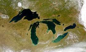 | |
| Secondary lakes | ||
| Bays and Waterways |
| |
| Islands |
| |
| Historic geology |
| |
| Government |
| |
| Related topics |
| |
Upper Peninsula of Michigan | |
|---|---|
| Central cities |
|
| Counties |
|
| Geography |
|
| Transportation |
|
| Economy |
|
| |