Corona, California
Corona (Spanish for ''Crown'') is a city in Riverside County, California, United States. As of the 2010 census, the city had a population of 152,374, up from 124,966 at the 2000 census. The cities of Norco and Riverside lie to the north and northeast, Chino Hills and Yorba Linda to the northwest, and the Cleveland National Forest and the Santa Ana Mountains to the southwest, and unincorporated Riverside County along the rest of the border, respectively. Corona is approximately 48 miles (77 km) southeast of Los Angeles and 95 miles (153 km) north-northwest of San Diego.
Corona, California | |
|---|---|
City | |
| City of Corona | |
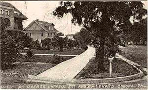
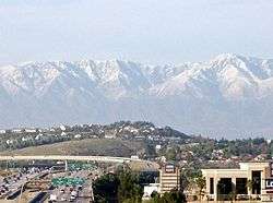 A view of Corona | |
 Seal | |
| Nicknames: | |
| Motto(s): "To Cherish Our Past, To Plan Our Future" | |
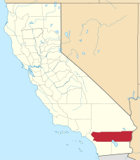
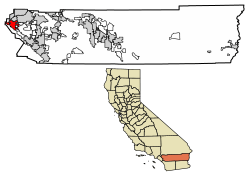 Location of Corona in Riverside County, California | |
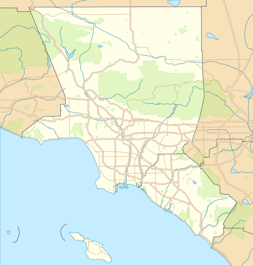 Corona Location within Greater Los Angeles 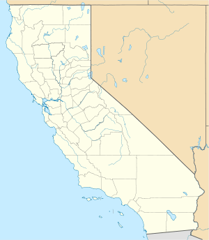 Corona Location within California  Corona Location in the United States | |
| Coordinates: 33°52′N 117°34′W | |
| Country | |
| State | |
| County | |
| Incorporated | July 13, 1896[3] |
| Government | |
| • Type | Council–manager[4] |
| • Mayor | Jim Stiener[4] |
| Area | |
| • City | 39.55 sq mi (102.45 km2) |
| • Land | 39.47 sq mi (102.23 km2) |
| • Water | 0.08 sq mi (0.21 km2) 0.27% |
| Elevation | 679 ft (207 m) |
| Population | |
| • City | 152,374 |
| • Estimate (2018)[8] | 168,819 |
| • Rank | 3rd in Riverside County 31st in California 154th in the United States |
| • Density | 4,277.15/sq mi (1,651.36/km2) |
| • Metro | 4,224,851 |
| Time zone | UTC-8 (Pacific) |
| • Summer (DST) | UTC-7 (PDT) |
| ZIP codes | 92877–92883 |
| Area code | 951 |
| FIPS code | 06-16350 |
| GNIS feature IDs | 1652691, 2410232 |
| Website | City Government Tourism site |
Corona, located along the western edge of Southern California's Inland Empire region, is known as the "Circle City" due to Grand Boulevard's 3-mile (5 km) circular layout. It is one of the most residential cities in the Inland Empire, but also has a large industrial portion on the northern half. It is the headquarters of companies such as Fender Musical Instruments Corporation, Monster Beverage Corporation, and supercar manufacturer Saleen.

History
Corona, originally named South Riverside, was founded at the height of the Southern California citrus boom in 1886, and is situated at the upper end of the Santa Ana River Canyon, a significant pass through the Santa Ana Mountains. The town of Corona was once the "Lemon Capital of the World". A museum there presents the lemon's former role in the local economy. The city derived its name (and its nickname, "The Circle City") from the unique layout of its streets, with a standard grid enclosed by the circular Grand Boulevard, 2.75 miles (4.43 kilometers) in circumference.[9] The street layout was designed by Hiram Clay Kellogg, a civil engineer from Anaheim who was an influential figure in the early development of Orange County.
Corona was established as a town by the South Riverside Land and Water Company. The company was incorporated in 1886; founding members included ex-Governor of Iowa Samuel Merrill, R.B. Taylor, George L. Joy, A.S. Garretson, and Adolph Rimpau.[10] Originally a citrus growers' organization, it purchased the lands of Rancho La Sierra of Bernardo Yorba, and the Rancho Temescal grant and the colony of South Riverside was laid out. They also secured the water rights to Temescal Creek, its tributaries and Lee Lake. Dams and pipelines were built to carry the water to the colony. In 1889, the Temescal Water Company was incorporated, to supply water for the new colony. This company purchased all the water-bearing lands in the Temescal valley and began drilling artesian wells.[11]
Originally located in San Bernardino County, the city was named "South Riverside" and received its post office in that name on August 11, 1887.[12] In 1893, South Riverside became part of the new Riverside County. In 1896, the city was renamed "Corona" for its circular Grand Boulevard, where three international automobile races were held in 1913, 1914 and 1916.[13]
The city of Corona has been popular among celebrities drawn to its upscale areas and relative privacy compared to Los Angeles. Lucille Ball and Desi Arnaz spent time at their ranch, located in north Corona, and played golf often at the Cresta Verde Golf Course in the northeastern section of the city.[14] After their divorce, Mr. Arnaz continued to live in Corona.
In recent years Corona has been known as the "Gateway to the Inland Empire". Prior to the 1980s, the city was largely an agricultural community, dominated by citrus orchards, ranches, and dairy farms. High real estate prices in Los Angeles and Orange counties made the area's land desirable to developers and industrialists, and by the late 1990s Corona was considered a major suburb of Los Angeles.
Housing development in the city has been accelerated by access to the area via the SR 91, with many families leaving Orange County to larger, more affordable housing available in the city. The construction of the nearby SR 71 has linked Corona to the Pomona and San Gabriel valleys. Due to traffic caused by Corona's considerable growth, toll lanes have been built along the 91 freeway, with future toll lane expansions under construction and in the planning stages along Interstate 15. While there were talks to construct a proposed 10 mi (16 km) automobile and rail tunnel under Santiago Peak to connect Interstate 15 in Corona with Interstate 5 and SR 55 in Orange County to reduce commuter traffic on the crowded 91 freeway, this concept has been shelved indefinitely.
In 2002, the city government considered an initiative to secede from Riverside County and form an autonomous Corona County because the city government and some residents were dissatisfied with how services were handled in nearby areas. The effort was also considered by areas in other cities in the western part of the county as far south as Murrieta. Whether nearby cities such as Norco would have been included in the new county are unknown. The proposed county would have been bordered by San Bernardino County to the northwest, and by Orange County to the west, but it never came to fruition.[15]
Historical markers
| Name | Date placed | Description | Location | Placed by |
|---|---|---|---|---|
| Butterfield Stage Station | 1934 | First used 1858 | 20730 Temescal Canyon Road | Corona Woman's Improvement Club |
| Corona Founders Monument | 1936 | Land purchase of May 4, 1886 | Corona City Park | 20-30 Club of Corona |
| Old Temescal Road | 1959 | Route of Luiseno and Gabrieleno Indians, and early white settlers | 11 mi (18 km) south on old Highway 71 | Corona Woman's Improvement Club and State Park Commission |
| Painted Rock | May 4, 1927 | Indian pictograph | Old Temescal Canyon Road | Corona Woman's Improvement Club |
| Third Serrano Adobe | 1981 | Owned by Josefa Serrano, widow of Leandro | I-15 and Old Temescal Road | E Clampus Vitus, Hydro Conduit Corp., Phil Porretta family |
| Serrano Tanning Vats | 1981 | Built 1819 | I-15 and Old Temescal Road | E Clampus Vitus, Hydro Conduit Corp., Phil Porretta family |
Geography and climate
Corona is located in western Riverside County, east of Orange County.
Corona is located at 33°52′N 117°34′W (33.8700, −117.5678).[17]
One of the most visible geographical features in Corona, visible from almost anywhere in the city, are the Santa Ana Mountains.
According to the United States Census Bureau, the city has a total area of 38.9 square miles (101 km2), of which, 38.8 square miles (100 km2) of it is land and 0.1 square miles (0.26 km2) of it (0.27%) is water.
Corona experiences a warm Mediterranean climate (Köppen climate classification CSa) and has mild to cool winters and hot summers. Most of the rainfall (as in all of Southern California) occurs during winter and early spring. Frost is not uncommon and happens mostly in December and January. Snowfall within city limits is rare, however the nearby Santa Ana Mountains receive a dusting of snow a few times each winter. Winter days are pleasant, with the average high staying around 65 and the average low around 40, occasionally dropping down to freezing. The spring brings pleasant weather, with little rain. Summertime is hot, with highs averaging in the low to mid 90s. During the hottest months, daytime temperatures in Corona can exceed 100 degrees.[18][19] In early summer, Corona receives common overcast weather known as "May Gray" and "June Gloom". Summer thunderstorms are sporadic and usually happen between July and September from the North American Monsoons, bringing increased humidity and scattered thunderstorms. Fall brings sunny and slightly cooler weather with little rain, but can be windy due to the Santa Ana winds, blowing in 2 or 3 times a year from October to December.
| Climate data for Corona, California | |||||||||||||
|---|---|---|---|---|---|---|---|---|---|---|---|---|---|
| Month | Jan | Feb | Mar | Apr | May | Jun | Jul | Aug | Sep | Oct | Nov | Dec | Year |
| Record high °F (°C) | 91 (33) |
93 (34) |
100 (38) |
100 (38) |
107 (42) |
110 (43) |
118 (48) |
113 (45) |
114 (46) |
108 (42) |
99 (37) |
94 (34) |
118 (48) |
| Average high °F (°C) | 66 (19) |
69 (21) |
71 (22) |
77 (25) |
80 (27) |
87 (31) |
92 (33) |
93 (34) |
90 (32) |
83 (28) |
74 (23) |
68 (20) |
79 (26) |
| Average low °F (°C) | 40 (4) |
43 (6) |
45 (7) |
48 (9) |
52 (11) |
57 (14) |
62 (17) |
64 (18) |
60 (16) |
52 (11) |
45 (7) |
42 (6) |
51 (11) |
| Record low °F (°C) | 19 (−7) |
25 (−4) |
25 (−4) |
28 (−2) |
28 (−2) |
39 (4) |
41 (5) |
41 (5) |
41 (5) |
29 (−2) |
26 (−3) |
22 (−6) |
19 (−7) |
| Average precipitation inches (mm) | 3.01 (76) |
3.06 (78) |
2.31 (59) |
.79 (20) |
.26 (6.6) |
.04 (1.0) |
.06 (1.5) |
.12 (3.0) |
.24 (6.1) |
.45 (11) |
1.07 (27) |
2.08 (53) |
13.50 (343) |
| Average precipitation days | 6.9 | 7.0 | 5.5 | 3.7 | 1.2 | 0.3 | 1.0 | 1.2 | 1.7 | 2.2 | 4.1 | 6.2 | 41 |
| Mean monthly sunshine hours | 195 | 215 | 260 | 310 | 305 | 300 | 380 | 365 | 290 | 250 | 210 | 205 | 3,285 |
| Source: [20] | |||||||||||||
Economy
Businesses headquartered in Corona include:
- Monster Beverage, a worldwide manufacturer of soft drinks, including Hansen's beverages and the Monster Energy drink line.[21]
- Saleen, manufacturer of specialty, high-performance sports cars.[22]
- Lucas Oil Products, manufacturer of automotive additive products and owner of naming rights to Lucas Oil Stadium, home venue of the Indianapolis Colts of the NFL.
- Premium automotive television channel MAVTV, which Lucas Oil owns, is also based in Corona.
- LuLaRoe, a women's clothing multi-level marketing distributor.
- Sterno
Top employers
According to the City's 2017 Comprehensive Annual Financial Report,[23] the top employers in the city are:
| # | Employer | # of Employees |
|---|---|---|
| 1 | Corona-Norco Unified School District | 5,399 |
| 2 | Corona Regional Medical Center | 1,113 |
| 3 | Kaiser Permanente | 995 |
| 4 | All American Asphalt | 840 |
| 5 | City of Corona | 805 |
| 6 | Fender | 650 |
| 7 | Monster Energy | 607 |
| 8 | TWR Framing | 600 |
| 9 | Thermal Structures | 500 |
| 10 | Veg-Fresh Farms | 425 |
| 11 | Core-Mark | 421 |
Demographics
| Historical population | |||
|---|---|---|---|
| Census | Pop. | %± | |
| 1900 | 1,434 | — | |
| 1910 | 3,540 | 146.9% | |
| 1920 | 4,129 | 16.6% | |
| 1930 | 7,018 | 70.0% | |
| 1940 | 8,764 | 24.9% | |
| 1950 | 10,223 | 16.6% | |
| 1960 | 13,336 | 30.5% | |
| 1970 | 27,519 | 106.4% | |
| 1980 | 37,791 | 37.3% | |
| 1990 | 76,095 | 101.4% | |
| 2000 | 124,966 | 64.2% | |
| 2010 | 152,374 | 21.9% | |
| Est. 2018 | 168,819 | [8] | 10.8% |
| U.S. Decennial Census[24] | |||
2010
The 2010 United States Census[25] reported that Corona had a population of 152,374. The population density was 3,914.0 people per square mile (1,511.2/km²). The racial makeup of Corona was 90,925 (59.7%) White (40.1% Non-Hispanic White),[26] 8,934 (5.9%) African American, 1,153 (0.8%) Native American, 16,205 (10.6%) Asian, 552 (0.4%) Pacific Islander, 28,003 (18.4%) from other races, and 7,759 (5.1%) from two or more races. Hispanic or Latino of any race were 66,447 persons (41.9%); 33.7% of Corona's population are Mexican-American, 2.1% Puerto Rican, 1.4% Cuban, 1.3% Salvadoran, 1.2% Guatemalan, 0.8% Peruvian, 0.5% Argentine, 0.3% Honduran, 0.2% Nicaraguan, and 0.2% Ecuadorian. Among Asian-Americans, 2.3% of Corona's population were Filipino, 2.1% Vietnamese, 1.7% Korean, 1.4% Indian-Americans, 1.1% Chinese, 0.7% Japanese, 0.4% Pakistani, 0.2% Thai, and 0.1% Bangladeshi. The second largest group of Corona's population is made up of Caucasian-Americans; the largest groups of whites were 11.1% German-American, 7.0% English, 6.9% Irish, 4.0% Italian, 2.7% French, 1.6% Polish, 1.5% Dutch, 1.4% Norwegian, 1.3% Scottish, 1.3% Swedish and 1.3% Arab.[27]
The Census reported that 151,863 people (99.7% of the population) lived in households, 229 (0.2%) lived in non-institutionalized group quarters, and 282 (0.2%) were institutionalized.
There were 44,950 households, out of which 22,735 (50.6%) had children under the age of 18 living in them, 27,357 (60.9%) were opposite-sex married couples living together, 5,971 (13.3%) had a female householder with no husband present, 3,004 (6.7%) had a male householder with no wife present. There were 2,690 (6.0%) unmarried opposite-sex partnerships, and 360 (0.8%) same-sex married couples or partnerships. 6,455 households (14.4%) were made up of individuals and 2,224 (4.9%) had someone living alone who was 65 years of age or older. The average household size was 3.38. There were 36,332 families (80.8% of all households); the average family size was 3.72.
The population was spread out with 45,674 people (30.0%) under the age of 18, 15,504 people (10.2%) aged 18 to 24, 44,215 people (29.0%) aged 25 to 44, 35,801 people (23.5%) aged 45 to 64, and 11,180 people (7.3%) who were 65 years of age or older. The median age was 32.5 years. For every 100 females, there were 97.0 males. For every 100 females age 18 and over, there were 94.5 males.
There were 47,174 housing units at an average density of 1,211.8 per square mile (467.9/km²), of which 30,210 (67.2%) were owner-occupied, and 14,740 (32.8%) were occupied by renters. The homeowner vacancy rate was 2.3%; the rental vacancy rate was 5.3%. 103,170 people (67.7% of the population) lived in owner-occupied housing units and 48,693 people (32.0%) lived in rental housing units.
During 2009–2013, Corona had a median household income of $77,123, with 10.8% of the population living below the federal poverty line.[26]
2000
As of the census[28] of 2000, there were 124,996 people, 37,839 households, and 30,384 families residing in the city. The population density was 3,555.5 people per square mile (1,372.7/km²). There were 39,271 housing units at an average density of 1,117.3 per square mile (431.4/km²). The racial makeup of the city was 75.0% White, 6.4% Black or African American, 0.9% Native American, 7.5% Asian, 0.3% Pacific Islander, 17.5% from other races, and 5.3% from two or more races. 25.5% of the population were Hispanic or Latino of any race.
There were 37,839 households out of which 49.6% had children under the age of 18 living with them, 63.8% were married couples living together, 11.2% had a female householder with no husband present, and 19.7% were non-families. 14.4% of all households were made up of individuals and 3.8% had someone living alone who was 65 years of age or older. The average household size was 3.3 and the average family size was 3.6.
In the city, the population was spread out with 33.4% under the age of 18, 8.9% from 18 to 24, 35.1% from 25 to 44, 16.8% from 45 to 64, and 5.8% who were 65 years of age or older. The median age was 30 years. For every 100 females, there were 98.0 males. For every 100 females age 18 and over, there were 95.6 males.
The median income for a household in the city was $98,615, and the median income for a family was $83,505 (these figures had risen to $88,620 and $95,450 respectively as of a 2007 estimate[29]). Males had a median income of $44,752 versus $31,884 for females. The per capita income for the city was $21,001. About 6.0% of families and 8.3% of the population were below the poverty line, including 10.1% of those under age 18 and 7.3% of those age 65 or over.
Neighborhoods
North Corona
The north part of the city of Corona borders the city of Norco. This area (north of State Route 91) is primarily residential and commercial. The makeup is primarily middle and upper-middle income, with most housing being built after the late 1990s, and is known for being well maintained and safe. Prominent areas include Corona Hills and Corona Ranch.
Downtown/North Main
Most of the City's downtown area lies north of State Route 91, and is home to the former Fender Museum (now the new Corona Community Center). The area has office and apartment buildings. Downtown is also the location of the North Main Corona Metrolink station, which is one of two Metrolink stations in the city.
Central Corona
The central city area includes the inner circle of Grand Avenue as well as all areas south of State Route 91 and north of Ontario Avenue. This is the oldest area of the city by far, with most housing having been built around 1910. This part of the city has a mixed Hispanic and white population, and consists of many restored historic residences.
South Corona
South Corona is the newest part of Corona and is located south of Ontario Avenue. Most of the housing was built after the early 2000s. This area has the highest rated schools in the city (as well as some of the highest in the region).
Sierra Del Oro
Sierra Del Oro is the western portion of Corona, comprising the neighborhoods situated along Green River Road, extending all the way towards State Route 91 and the Orange/Riverside county line. This area holds many apartment complexes geared towards commuters, along with the West Corona Metrolink station. The Corona Auto Center is located at the base of the foothills. In December 2016, construction of the Foothill Parkway expansion was completed, allowing a direct street link between Sierra Del Oro and South Corona.
Dos Lagos
Dos Lagos is located near the southern city limits of Corona, straddling Interstate 15. The area is mostly dominated by upscale apartment complexes, newer homes, a shopping center, and a large golf course.
Coronita
Coronita is an unincorporated, census-designated area in Riverside County enclosed in western Corona. An annexation attempt in 1986 by the city failed.[30]
Temescal Valley
Temescal Valley is an unincorporated but census-designated area in Riverside County at the southernmost end of Corona city limits, and is included in the city's sphere of influence. It includes the neighborhoods of Sycamore Creek, Trilogy, The Retreat and Horsethief Canyon Ranch. In 2013, the City of Corona applied for annexation of the area through the Riverside County Local Agency Formation Commission (LAFCO).[31] On September 26, 2013, however, the Commission formally denied the City of Corona's request for annexation.[32] The contract between Corona and the County to provide its emergency services to the northern-third of Temescal Valley persists.[33]
Although the arguments of the opponents of annexation included the fear of being "Coronians" and losing the area's identity, Temescal Valley's ZIP Code remains associated with Corona.[34]
Home Gardens
Home Gardens is a census-designated place (CDP) within the City of Corona's sphere of influence. The neighborhood is largely populated by Hispanic and Caucasian communities. Home Gardens is one of Corona's largest neighborhoods with a population estimate of approximately 12,000 residents. It is also one of the city's lowest-income areas. The neighborhood is served by Magnolia Avenue, a major thoroughfare which leads into the City of Riverside. Bus service is provided by the Riverside Transit Agency (RTA) and Corona Cruiser.
El Cerrito
El Cerrito is located on the southeastern part of the city, just a few exits north of the Dos Lagos neighborhood on I-15. El Cerrito is mostly a rural/suburban area with many dirt roads in alleyways and no ranches. El Cerrito is home to El Cerrito Sports Park, a large park consisting of one baseball field and a popular destination for Little League Baseball and local school softball teams. El Cerrito is served by Ontario Avenue/Temescal Canyon Road.
Eagle Glen
Eagle Glen is located between South Corona and El Cerrito, and is the neighborhood around Wilson Elementary and Eagle Glen. It is close to Wilson Elementary, El Cerrito Middle School and Santiago High School, all of which are California distinguished schools. Eagle Glen is also home to a golf course.
Government
In the California State Legislature, Corona is located in the 31st Senate District, represented by Democrat Richard Roth, and in the 60th Assembly District, represented by Democrat Sabrina Cervantes.[35]
In the United States House of Representatives, Corona is located in California's 42nd congressional district, represented by Republican Ken Calvert.[36] California is represented in the United States Senate by Democrats Dianne Feinstein and Kamala Harris.
Infrastructure
Transportation

The city is served by the Chino Valley (SR 71), Ontario (I-15), and Riverside (SR 91) freeways.
The city is also linked with the 91 Line and Inland Empire–Orange County Line of the Metrolink commuter rail system, providing service to Los Angeles, Perris, San Bernardino, and Oceanside from North Main Corona Metrolink Station in the Downtown area and West Corona Metrolink Station in Corona's West Side.
The city's downtown area is circled by Grand Boulevard, which is unique for being perfectly circular. The street is approximately 1 mi (1.6 km) in diameter.
Corona's public transportation includes the following bus lines: RTA route 1 from West Corona to UC Riverside, RTA route 3 from Corona Regional Medical Center to Swan Lake in nearby Eastvale, RTA route 214 from Downtown Corona to The Village shopping center in Orange, RTA route 206 from Downtown Corona to Temecula, OCTA bus route from Anaheim to South Corona Walmart (Ontario Avenue), and the Corona Cruiser blue and red lines.
There is a proposal to erect a new four-lane freeway along or near Cajalco Road to connect Interstates 15 and 215, although the plan remains controversial. In addition, there is a possibility of constructing a 7.5 mi (12.1 km) tunnel under the Santiago Peak Mountains to the Eastern Transportation Corridor of the FastTrak toll-road company system in Orange, due to increased commuter traffic on State Route 91, which needs to be reduced by another freeway between Orange and Riverside counties.
Corona Municipal Airport (FAA designator: AJO) serves the city and has a 3,200-foot (980 m) runway. On January 20, 2008, two small passenger aircraft collided over Corona, killing all four men aboard the planes and another man on the ground. In the past ten years, there have been five fatal plane crashes around Corona.
Healthcare
Corona is served by the following three hospitals:
Education
The city of Corona is a part of the Corona-Norco Unified School District.[38]
There are five high schools in Corona: Corona, Centennial, Lee V. Pollard, Orange Grove, Santiago.
There are five middle schools in Corona: Auburndale, Citrus Hills, Corona Fundamental, El Cerrito, Raney.
There are also 28 elementary schools in the city: John Adams, Susan B. Anthony, Cesar Chavez, Corona Ranch, Coronita, Dwight Eisenhower, Foothill, Ben Franklin, Garretson, Home Gardens, Jefferson, Lincoln Alternative, William McKinley, Orange, Parkridge, Prado View, Promenade, Riverview, Ronald Reagan, Sierra Vista, Stallings, Temescal Valley, Dr. Bernice Todd, Vandermolen, Vicentia, Victress Bower, George Washington and Woodrow Wilson.
Private schools include St. Edward Catholic School[39] and Crossroads Christian School.
Nonprofit associations
The World Mosquito Control Association (WMCA) is located in Corona.[40]
Utilities
Southern California Edison provides most of the city's electricity and a small part of the city is serviced by Corona Department of Water and Power. Waste Management Inc. provides waste disposal for the city.
Arts and culture
Performing arts
The Arts Alive Council is a non-profit organization created with the purpose to "foster, promote, and increase the public knowledge and appreciation of the arts and cultural activities in the greater Corona Area." Members include the Corona Symphony Orchestra, Circle City Chorale, Christian Arts and Theater, and Corona Dance Academy.[43]
Off Broadway Corona Theater (OBCTheater) is a non-profit organization. They produce two to three theatrical productions each year that are presented at the Corona Civic Center Auditorium.[44]
Notable people
- Travis Barker – drummer for Blink-182, Boxcar Racer, The Transplants, and +44
- Vontaze Burfict – football linebacker for Oakland Raiders
- Ken Calvert - United States Representative
- Richard Dornbush - figure skater[45]
- Heath Farwell – football linebacker
- Cirilo Flores - Roman Catholic bishop
- Troy Glaus – former baseball player Los Angeles Angels[46]
- Larissa "Bootz" Hodge – reality television participant, Flavor of Love 2, Flavor of Love Girls: Charm School
- Tyler Hoechlin – actor, baseball player
- Candy Johnson – dancer and singer in 1960s AIP "beach" movies
- Matt Kalil – football offensive lineman who is currently a free agent
- Ryan Kalil – football offensive lineman for the New York Jets
- Joe Kelly – Major League Baseball starting pitcher[47]
- Kerry King – guitarist for Slayer[48]
- Denny Lemaster - MLB pitcher
- Nikki Leonti - singer-songwriter, actress[49]
- Crystal Lewis – Christian music singer, TV actress[50]
- Jason Martin – MLB outfielder
- Taylor Martinez – former quarterback for Nebraska Cornhuskers
- Taryne Mowatt – All-American softball pitcher for Arizona Wildcats and two-time ESPY Award winner
- Ricky Nolasco – Major League Baseball pitcher for Los Angeles Angels
- Michael Parks - actor, Kill Bill, Red State, The Happening and other films
- Lonie Paxton – former NFL player for New England Patriots and Denver Broncos
- Asia Monet Ray - dancer, recording artist, former Dance Moms cast member
- Shawn Ray - former professional bodybuilder and author
- Jenni Rivera – vocalist, songwriter of banda music
- Chance Sisco - baseball player for Baltimore Orioles
- D.J. Strawberry – professional basketball player
- Jodie Sweetin – actress known for her role as Stephanie Tanner on television sitcom Full House[51]
- Brice Turang - baseball player for Milwaukee Brewers[52]
- Gary Webb – investigative journalist
- Marcus Alan Williams - football safety for the New Orleans Saints[53]
Sister cities
The following are Corona's sister cities as designated by Sister Cities International.[54]
See also
- Freeway Complex Fire – a 2008 wildfire that started at the Yorba Linda/Corona city limit line.
- Rancho Temescal (Serrano)
References
- PE.com: Corona: Circle citys circle makes national register
- Corona, California: The city that doubled as a race course. Hemmings Daily. Retrieved 2013-11-05.
- "California Cities by Incorporation Date". California Association of Local Agency Formation Commissions. Archived from the original (Word) on November 3, 2014. Retrieved August 25, 2014.
- "City Council". City of Corona. Retrieved January 14, 2020.
- "2016 U.S. Gazetteer Files". United States Census Bureau. Retrieved July 19, 2017.
- "Corona". Geographic Names Information System. United States Geological Survey. Retrieved October 23, 2014.
- "Corona (city) QuickFacts". United States Census Bureau. Retrieved April 12, 2015.
- "Population and Housing Unit Estimates". Retrieved June 7, 2019.
- "Corona: 'Circle City' to mark centennial of road races". The Press-Enterprise. August 16, 2013.
...Grand Boulevard seems a quaint oddity. A perfect circle, with a circumference just over 2.75 miles, it's the rationale for Corona's tagline as the 'Circle City'.
- Finding aid of South Riverside Land and Water Company records, Online Archive of California from oac.cdlib.org accessed April 26, 2015.
- Ellerbe, History of Temescal Valley, pp. 18–19
- Frickstad, Walter N., A Century of California Post Offices 1848-1954, Philatelic Research Society, Oakland, CA. 1955, pp.135-147
- Hoover, Mildred B.; Hero Rensch; Ethel Rensch; William N. Abeloe (1966). Historic Spots in California. Stanford University Press. ISBN 978-0-8047-4482-9.
- http://www.crestaverde.com
- Santa Barbara News Press article on the county split proposal, with a brief mention of the proposed Corona County.
- Johnson, Marael (1995). Why Stop? A Guide to California Roadside Historical Markers. Houston, TX: Gulf Publishing Company. pp. 38–39. ISBN 978-0884159230. OCLC 32168093.
- "US Gazetteer files: 2010, 2000, and 1990". United States Census Bureau. February 12, 2011. Retrieved April 23, 2011.
- www.weather.com
- "Past Weather in Corona, California, USA — Yesterday or Further Back".
- "Corona weather averages". Weather. Retrieved May 29, 2011.
- Monster Beverage Corporation. (2018). Retrieved from https://www.monsterbevcorp.com/
- "Saleen Headquarters | Saleen". Retrieved January 18, 2019.
- City of Corona CAFR
- "Census of Population and Housing". Census.gov. Retrieved June 4, 2015.
- "2010 Census Interactive Population Search: CA - Corona city". U.S. Census Bureau. Archived from the original on July 15, 2014. Retrieved July 12, 2014.
- http://quickfacts.census.gov/qfd/states/06/0616350.html. Missing or empty
|title=(help) - U.S. Census Bureau, Census 2010 Summary File 3, Matrices P18, P19, P21, P22, P24, P36, P37, P39, P42, PCT8, PCT16, PCT17, and PCT19
- "U.S. Census website". United States Census Bureau. Retrieved 2008-01-31.
- "Corona 2007 Income Estimates". Archived from the original on February 12, 2020. Retrieved May 3, 2009.
- Surman, Barry S. (July 15, 1986). "Coronita Residents Defeat Attempts at Incorporation". Los Angeles Times.
- http://www.pe.com/local-news/politics/jeff-horseman-headlines/20130730-temescal-valley-county-supervisors-oppose-coronas-annexation-plan.ece
- http://www.pe.com/local-news/riverside-county/corona/corona-headlines-index/20130926-corona-temescal-valley-annexation-denied.ece
- http://www.pe.com/local-news/riverside-county/corona/corona-headlines-index/20130920-temescal-valley-commission-staff-dont-support-coronas-annexation-bid.ece
- "ZIP Code™ Lookup | USPS".
- "Statewide Database". UC Regents. Archived from the original on February 1, 2015. Retrieved November 30, 2014.
- "California's 42nd Congressional District - Representatives & District Map". Civic Impulse, LLC.
- California Department of Health Services Archived December 29, 2012, at the Wayback Machine
- "Corona-Norco Unified School District". 2009. Retrieved October 23, 2009.
- "St Edward School". stedward1947.com. Retrieved February 22, 2020.
- Webpage of the WMCA
- 33.8691826°N 117.5464378°W USGS Geographic Names Information System (GNIS)
- Corona Sunnyslope Cemetery
- "Mission Statement".
- "About | BUSINESS NAME".
- "International Skating Union Bio: Richard Dornbush". Retrieved April 2, 2014.
- "Troy Glaus Stats". Baseball-Reference.com. Retrieved September 13, 2019.
- "Joe Kelly Stats". Baseball-Reference.com. Retrieved September 13, 2019.
- "After Jeff Hanneman's Death, "We Had to Learn How to Be Slayer in a New Way"". LA Weekly. June 14, 2015. Retrieved March 18, 2017.
- Conner, Matt (October 25, 2018). "Where Are They Now: Catching Up with Nikki Leonti". CCM Magazine. Retrieved September 13, 2019.
- "Autobiography: Crystal Lewis Official Website". www.crystallewis.com. Archived from the original on May 5, 2010. Retrieved June 14, 2010.
- Dyball, Rennie. "Full House's Jodie Sweetin "I Can't Believe How Far I've Come" – Babies, Personal Success, Substance Abuse, Jodie Sweetin : People.com". www.people.com. Retrieved June 14, 2010.
- "Brice Turang Minor Leagues Statistics & History". Baseball-Reference.com. Retrieved September 13, 2019.
- "Bell Tolls: Saints' Marcus Williams is determined that rookie gaffe won't define him". USA TODAY. Retrieved September 13, 2019.
- "Archived copy". Archived from the original on August 16, 2016. Retrieved July 31, 2016.CS1 maint: archived copy as title (link)
External links
| Wikimedia Commons has media related to Corona, California. |
- Official website
- InnerCircleCorona – a community communications system partially sponsored by the City of Corona
- Corona, California at Curlie
Municipalities and communities of Riverside County, California, United States | ||
|---|---|---|
| Cities |
|  Riverside County map |
| CDPs |
| |
| Unincorporated communities |
| |
| Indian reservations |
| |
| Ghost towns |
| |
| Central city |  | |
|---|---|---|
| Counties |
| |
| Cities >200k | ||
| Cities and towns 100k−200k |
| |
| Other towns |
| |
| Other communities |
| |
| Area regions |
| |
| Landforms |
| |
| Bodies of water |
| |
| |
^* Mayor selected from city council |
| Authority control |
|
|---|