Concepción, Chile
Concepción (Spanish pronunciation: [kon.sepˈsjon] (![]()
Concepción La Concepción de María Purísima del Nuevo Extremo (original name) | |
|---|---|
City and Commune | |
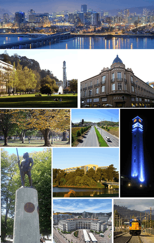 Collage from Concepción, Top: Skyline; Upper left: University of Concepción; Upper right: Store in downtown; Middle left: Ecuador Park; Middle center: Bonilla/Alonso de Ribera Highway; Middle right: University of Concepción clock tower; Lower left: Lautaro statue; Lower center: San Sebastián University; Bottom center: Court of Appeals; Bottom right: Biotrén. | |
 Flag .svg.png) Coat of arms  Location in the Bío Bío Region 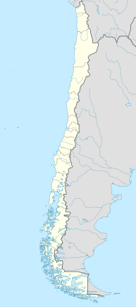 Concepción Location in Chile | |
| Nicknames: Biobío's Pearl, The University City, The cradle of Chilean rock | |
| Motto(s): La Capital del Sur de Chile The Capital of Southern Chile | |
| Coordinates (Alcalde's office): 36°49′41.50″S 73°03′04.93″W | |
| Country | Chile |
| Region | Bío Bío |
| Province | Concepción |
| Founded | October 5, 1550 |
| Founded by | Pedro de Valdivia |
| Government | |
| • Type | Municipality |
| • Alcalde | Álvaro Ortiz (DC) |
| Area | |
| • City and Commune | 222 km2 (86 sq mi) |
| Elevation | 12 m (39 ft) |
| Population (2006) | |
| • City and Commune | 992,589 |
| • Density | 1,318/km2 (3,410/sq mi) |
| • Metro | 1,322,581 |
| Demonym(s) | Penquista |
| Time zone | UTC−4 (CLT) |
| • Summer (DST) | UTC−3 (CLST) |
| Post code | 3349001 |
| Telephone prefix | 56 + 41 |
| Climate | Csb |
| Website | www |
Greater Concepción (Gran Concepción, including Talcahuano, San Pedro de la Paz, Hualpén, Chiguayante, Penco, Tomé, Lota, Coronel, Hualqui and Concepción) is the second-largest conurbation in the country, with 945,650 inhabitants (2012 census). Individually, it is the 11th largest commune in the country, with a population of 229,665.[6]
History
.jpg)
.jpg)
Concepción was founded by Don Pedro de Valdivia[FN 1] in 1550 north of the Bío Bío River, at the site which is today known as Penco. At that time it was given the name Concepción de María Purísima del Nuevo Extremo (Mary Immaculate Conception of the New End). The new settlement of Concepción was just a few kilometers north of La Frontera (The Frontier), the boundary between Spanish territory and the land of the Mapuche, an American Indian ethnic group that remained independent until the 1870s. The settlement was formally recognized by the Spanish authorities as a town two years later by a royal decree. It was given a coat-of-arms that is still in use today.
At the time of the Spanish arrival to the Concepción area chronicler Jerónimo de Vivar noted local Mapuches wore gold and silver bracelets and "sort of crowns". This is interpreted either as Incan gifts, war spoils from defeated Incas, or adoption of Incan metallurgy.[7]
Although Concepción was a significant military settlement for the Captaincy General of Chile, it was overrun and destroyed by Mapuche armies in 1554, and once again after being refounded in 1555. Concepción was restored during the governorship of García Hurtado de Mendoza when he landed there and built a fort on the Alto de Pinto in 1557. The town was refounded once more on January 6, 1558, by captain Jerónimo de Villegas. It became the headquarters of the military forces engaged against the Mapuche in La Araucanía over the next two centuries, growing to a population of 10,000 despite a siege in 1564 and other attacks by the Mapuche. Concepción was the home of the Real Audiencia from 1565 to 1575.
Earthquakes and tsunamis, which razed the town in 1570, 1657, 1687, 1730 and 1751, led the authorities to move the town to its current site in the Valle de la Mocha, alongside the Bío Bío River; the old site lay empty until March 29, 1842, when the present town of Penco was founded.
The new site for the town of Concepción became the main town of the Intendancy of Concepción, whose jurisdiction extended from the Maule River to La Frontera. The first Intendant of Concepción was the Irishman Ambrose O'Higgins, Marquis of Osorno, who later became Royal Governor of Chile and Viceroy of Peru.
When the First National Government Board met in Santiago on September 18, 1810, citizens of Concepción joined up. Concepción was used as the point of entry by the Spanish Army in the attempt by the Viceroyalty of Peru to re-conquer Chile. Concepción politicians and soldiers became a significant political force in the newly independent country.
On January 1, 1818, Ambrose O'Higgins's son, Bernardo O'Higgins, proclaimed and took the oath of the Chilean War of Independence in the main square of Concepción, which since then has been known as "Plaza de la Independencia". On February 20, 1835, the town again was largely destroyed by an earthquake and had to be rebuilt.
By 1875, a key British community and German colony existed within the province. By 1895, there was an even larger Spanish presence.[8]
Concepción is the second largest city of Chile. The Universidad de Concepción, founded in 1919, became the first secular private university in Chile. The neighboring harbor of Talcahuano is the site of the largest naval base in Chile.

On February 27, 2010, an 8.8 magnitude earthquake struck the city of Concepción, killing more than 521 people and injuring thousands nationwide. Following the earthquake, geologists relying on global positioning satellite (GPS) data concluded that the city had been displaced roughly 3 meters (9.8 feet) to the west as a result of the event.[9] The tsunami that followed missed the city.[10]
After the 2010 Chile earthquake, a prison riot began in Concepción's El Manzano prison following a failed escape attempt by the inmates. Different parts of the prison were set on fire and the riot was controlled only after the guards shot into the air and received help from military units.[11] As of 5 March 2010, a Peruvian field hospital has been deployed to the city.[12]
Seismology
Like most of Chilean territory, the Concepción region is seismically active, with much of Concepción destroyed by a violent earthquake in 1939. An earthquake in 1953 damaged 15% of the town's buildings. Another major earthquake in 1960 had a nearby epicenter.[FN 2]
On February 27, 2010, an earthquake of 8.8 magnitude struck at 35.846°S, 72.719°W, 115 km (71 mi) NNE of the city. The United States Geological Survey said the earthquake struck at 0334 GMT on Saturday at a depth of 35 km (22 mi). The effects were felt as far away as São Paulo, Brazil—2,870 miles (4,620 km).
Education
Concepción is known as "the university city"[13][14] thanks to the numerous universities within the urban agglomeration,[15] since one of the most important universities of the country were founded here, such as the Universidad de Concepción, Universidad Católica de la Santísima Concepción and Universidad del Biobío. This city also has numerous headquarters for many other universities. In addition, this metropolis has a large educational offer, focused on institutes, centers of technical formation and the universities already mentioned above.


Universities
The University Pencopolitana whose name was Pontificia Universidad Pencopolitana de La Concepción (Pontifical Pencopolitana University of The Conception) was an old university founded though a decree of the Bishop of Concepción, delivered to the administration of the Society of Jesus which functioned between the years 1724 and 1767. In May 24 of 1751 an earthquake followed by a tsunami, ravaged the city causing serious damage, including the destruction of the library of the University and all of its funds. As a product of the fury of the waters, a rich collection of texts of the governance of southern Chile were lost, which resulted in a disaster for the culture and collective memory of the city. Due to the natural disasters, it was decided to relocate the city to the called Valle de la Mocha, location where it is currently situated. Slowly the seminary was revived in the new location, in a period of decline in academic activity in Chilean monastic universities after the creation of the Universidad de San Felipe, yet some degrees continued to be granted before the Suppression of the Society of Jesus in 1767. The aforementioned University is considered to be the natural and legitimate predecessor of the Universidad Católica de la Santísima Concepción (UCSC), erected by the Archbishop of Concepción in 1991, from the Talcahuano Regional Headquarters of the Pontificia Universidad Católica de Chile.
The image of the Pontifical University of Concepción Pencopolitana, is still valid, for His Majesty King Juan Carlos I of Spain in his 1990 speech on the occasion of his inauguration as Doctor Honoris Causa in the University of Chile, in Santiago de Chile, said: "The work of the Pontifical University Pencopolitana should not be ignored, even before the creation of the University of San Felipe" (Juan Carlos's account fails to acknowledge the existence of San Felipe's predecessor, the Dominican Universidad de Santo Tomás de Aquino, from the sixteenth century in Santiago).
Meanwhile, the University of Chile allowed schools in the city to teach courses in law which allowed men to obtain a law degree. Among itsstudents was Henry Urrutia Manzano, who decades later became president of the Supreme Court of Chile.
The Universidad de Concepción was created in 1919 by a group of citizens including Enrique Molina Garmendia, its first rector.
Eventually the university began to receive state support, becoming part of the traditional universities, becoming one of three most important universities in the country, and the most importance at the regional level.
Traditional universities
- Universidad de Concepción
- Universidad del Bío-Bío
- Universidad Católica de la Santísima Concepción
- Universidad Técnica Federico Santa María
Private universities
- Universidad del Desarrollo
- Universidad Andrés Bello
- Universidad Arcis
- Universidad San Sebastián
- Universidad Santo Tomás
- University of the Pacific (Chile)
- Universidad de Las Américas
- Universidad Bolivariana
- Universidad Pedro de Valdivia
- Universidad La República
- Universidad de Aconcagua
- Universidad Tecnológica de Chile INACAP
Professional institutes
- Instituto Profesional DuocUC, of the Pontificia Universidad Católica de Chile
- Instituto Profesional Virginio Gómez, of the Universidad de Concepción
- Instituto Tecnológico, of the Universidad Católica de la Santísima Concepción
- Instituto Profesional Santo Tomás, of the Universidad Santo Tomás
- Instituto Profesional AIEP, of the Universidad Andrés Bello
- Instituto Profesional La Araucana
- Instituto Profesional Providencia
- Instituto de Estudios Bancarios Guillermo Subercaseaux
- Instituto Profesional Diego Portales
- Instituto Profesional Crecic
- Instituto Profesional Placex
- Instituto Profesional INACAP
Primary and secondary schools
The city has a French international school, the Lycée Français Charles de Gaulle and a German school, the Colegio Alemán de Concepción and a British school, Saint John's School, the former located in the city downtown and the latter examples in San Pedro de la Paz. [16]
Transportation
The city is served by Carriel Sur International Airport in Talcahuano.
Climate
The climate of Concepción is classified as Köppen Csb, with a dry summer nadir in February. The cool waters of the Pacific Ocean help to maintain mild temperatures throughout the year. Temperatures rarely exceed 30 °C (86 °F) or fall below 0 °C (32.0 °F). In the six-month period between May and October, the city receives approximately 83% of its total annual precipitation, which totals 1,130 mm (44 in). The wettest month since records began in 1912 was June 2000 with 565.7 millimetres (22.3 in), whilst all months from November to April have been rainless on occasions.[17] The maritime cooling brings much cooler temperatures than nearby inland areas on the same parallel in Argentina, where average summer highs match Concepción's all-time records. Summer temperatures for the 36 degrees latitude are rarely as cool as they are in Concepción, and on the Atlantic coast of Argentina, similar or hotter summer temperatures are found much further from the equator. However, this moderation is evident for the entire Chilean Pacific so is not unique for Concepción. Similar cool-summer mediterranean climate tendencies are found on the West Coast of North America on similar parallels, even though Concepción tends to have slightly wetter winters than San Francisco for example. Conversely, record winter nighttime temperatures in Concepcion are significantly more moderate than temperatures recorded on the Argentine Atlantic coast at the same latitude, where temperatures below −10 °C (14 °F) have occurred.[18]
| Climate data for Concepción, Chile (Carriel Sur International Airport) 1981–2010, extremes 1966–present | |||||||||||||
|---|---|---|---|---|---|---|---|---|---|---|---|---|---|
| Month | Jan | Feb | Mar | Apr | May | Jun | Jul | Aug | Sep | Oct | Nov | Dec | Year |
| Record high °C (°F) | 34.1 (93.4) |
33.2 (91.8) |
30.9 (87.6) |
27.2 (81.0) |
25.8 (78.4) |
22.0 (71.6) |
21.7 (71.1) |
25.0 (77.0) |
28.8 (83.8) |
27.6 (81.7) |
32.5 (90.5) |
33.4 (92.1) |
34.1 (93.4) |
| Average high °C (°F) | 22.8 (73.0) |
22.5 (72.5) |
21.0 (69.8) |
18.3 (64.9) |
15.4 (59.7) |
13.7 (56.7) |
13.2 (55.8) |
14.0 (57.2) |
15.5 (59.9) |
17.2 (63.0) |
19.4 (66.9) |
21.4 (70.5) |
17.9 (64.2) |
| Daily mean °C (°F) | 16.5 (61.7) |
15.9 (60.6) |
14.5 (58.1) |
12.3 (54.1) |
10.7 (51.3) |
9.5 (49.1) |
8.8 (47.8) |
9.3 (48.7) |
10.2 (50.4) |
11.9 (53.4) |
13.8 (56.8) |
15.6 (60.1) |
12.4 (54.3) |
| Average low °C (°F) | 10.9 (51.6) |
10.6 (51.1) |
9.8 (49.6) |
8.1 (46.6) |
7.5 (45.5) |
6.6 (43.9) |
5.8 (42.4) |
6.0 (42.8) |
6.1 (43.0) |
7.4 (45.3) |
8.7 (47.7) |
10.1 (50.2) |
8.1 (46.6) |
| Record low °C (°F) | 0.9 (33.6) |
3.6 (38.5) |
1.6 (34.9) |
−1.0 (30.2) |
−2.1 (28.2) |
−2.2 (28.0) |
−3.8 (25.2) |
−2.5 (27.5) |
−1.4 (29.5) |
−0.8 (30.6) |
1.0 (33.8) |
3.4 (38.1) |
−3.8 (25.2) |
| Average precipitation mm (inches) | 15.7 (0.62) |
15.4 (0.61) |
25.4 (1.00) |
72.4 (2.85) |
182.7 (7.19) |
230.7 (9.08) |
198.4 (7.81) |
153.6 (6.05) |
84.1 (3.31) |
57.2 (2.25) |
33.4 (1.31) |
21.3 (0.84) |
1,090.3 (42.93) |
| Average rainy days (≥ 1.0 mm) | 2.6 | 2.6 | 3.7 | 7.6 | 14.5 | 16.1 | 15.3 | 13.5 | 10.2 | 7.6 | 4.8 | 3.5 | 102.0 |
| Average relative humidity (%) | 75 | 77 | 80 | 83 | 87 | 88 | 86 | 85 | 82 | 81 | 78 | 76 | 82 |
| Mean monthly sunshine hours | 341 | 278 | 255 | 191 | 133 | 114 | 129 | 162 | 197 | 254 | 296 | 331 | 2,681 |
| Source #1: Dirección Meteorológica de Chile (precipitation days and humidity 1970–2000)[19][20][21] | |||||||||||||
| Source #2: Ogimet (sun 1981–2010)[22] | |||||||||||||
As might be expected for such a large urban area heavily dependent on wood-burning for heat and diesel for transport, the air in Concepción is the third-most polluted in Chile, after Santiago and Temuco.[23]
Demographics
| Historical population | ||
|---|---|---|
| Year | Pop. | ±% p.a. |
| 1970 | 161,006 | — |
| 1982 | 267,891 | +4.33% |
| 1992 | 326,784 | +2.01% |
| 2002 | 216,061 | −4.05% |
| 2006 | 225,158 | +1.04% |
| 2012 | 229,684 | +0.33% |
| Source: 1970–1992,[24] 2002,[25] 2006–2012[26] | ||
According to data collected on 2002 in the Census of the National Institute of Statistics, the township has an area of 221.6 km2 (86 sq mi) and a population of 216,061 inhabitants, of whom 103,860 are men and 112,201 are women.
Conception is home to 11.61% of the total population of the region. 1.88% (4,058 persons) is for rural population and 98.12% (212,003) to urban population.
Between 1970 and 1982 there is a large increase in the population. One reason is the inclusion of San Pedro, segregated from the municipality of Coronel.
The Concepción commune population declined sharply because in 1996 it was divided, creating Chiguayante and San Pedro de la Paz. In these communes the population has grown quickly since they have become bedroom communities of Concepción, i.e. residential cities that do not have a center with many shops, such as Concepcion.
It is projected that by 2009 an estimated population of 227,768 inhabitants live in the commune.[6]
There is a significant percentage of foreign residents in the city, the most numerous are the Spanish, Italian and US expatriate communities. There are also smaller segments of German, French, British, Dutch, Greek, Portuguese, Croatian, Scandinavian, Arab and Australian descendants in a city settled by waves of immigration.
Cultural life

To an outsider, there may be confusion between the demonyms of the inhabitants of Concepción and the nearby city of Penco. Due to the previous location of Concepción being where Penco currently stands, inhabitants of Concepción are called penquistas while inhabitants of Penco are known as pencones.
Concepción is one of the most active cities in Chilean rock music and many rock groups in Chile were formed in Concepción. The city has the second largest concentration of universities in Chile, and is home to Universidad de Concepción, Universidad Católica de la Santísima Concepción, Universidad Técnica Federico Santa María and Universidad del Bío Bío
Music
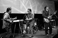
Concepción has been described as the "capital of Chilean rock", since numerous bands of this genre have been founded in the city, such as Los Tres, Los Bunkers, Emociones Clandestinas and Santos Dumont. Numerous bands have played their first major concerts in the city, such as Los Prisioneros.[27]
Concepción is also known as "the university city", for the number of universities that exist and which also represent an alternative to various regions of Chile.
Sports
Concepción is home of three professional football teams:
- Club Deportivo Universidad de Concepción, currently in the Primera División
- Club Deportivo Ferroviario Almirante Arturo Fernández Vial, currently in the Chilean second division
- Club de Deportes Concepción, currently in the Chilean third division.
Basketball is also played at a high professional level. The most notable team is:
- Club Deportivo Universidad de Concepción, currently in DIMAYOR, División Mayor del Básquetbol de Chile
Economy
Historically characterized by a strong manufacturing industry, Concepción has also been a major center for distribution and services and the financial basis of the regional economy.
Commerce
Trade in the city is concentrated in the Plaza Independencia (Independence Square), the pedestrian street Alonso de Ercilla y Zúñiga (built in 1981), and along the major avenues. One such avenue is the Diego Barros Arana street which has developed into the commercial center of the city and the region was until 1907 even known as "calle Comercio" ("Commerce Street"). New commercial centers are being developed around the old central station and the new civic district as a part of the Chilean bicentennial (September 18, 2010). A considerable percentage of local trade is taking place in settlements around the city, in communes such as Hualpén, Talcahuano and San Pedro de la Paz, where there are bustling shopping centers, such as Mall Plaza del Trébol, and where there is a constant commercial development.
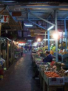
Other commercial spots, related to food, are the Vega Monumental and Mercado Central de Concepción (Central Market of Concepción) places offering various services and agricultural and livestock products.
Administration
As a commune, Concepción is a third-level administrative division of Chile administered by a municipal council, headed by an alcalde who is directly elected every four years. The 2016–2020 mayor is Alvaro Ortiz Vera (Christian Democratic Party), who was first elected in 2012. The communal council has 10 seats, which are currently occupied (2016–2020) by three for Christian Democratic Party, two for National Renewal, two for Independent Democrat Union, one for Communist Party, one for Socialist Party, and one for Radical Party. The following members are:[1]
| Seats | Councillor | Party |
|---|---|---|
| 1 | Fabiola Troncoso Alvarado | Christian Democratic |
| 2 | Yanina Contreras Álvarez | National Renewal |
| 3 | Jaime Monjes Farias | Christian Democratic |
| 4 | Emilio Armstrong Delpin | I.D.U. |
| 5 | Christian Paulsen Espejo-Pando | I.D.U. |
| 6 | Joaquin Eguiluz Herrera | National Renewal |
| 7 | Alex Iturra Jara | Communist |
| 8 | Boris Negrete Canales | Christian Democratic |
| 9 | Patricia Garcia Mora | Socialist |
| 10 | Ricardo Trostel Provoste | Radical |
Within the electoral divisions of Chile, Concepción is represented in the Chamber of Deputies by Gaston Saavedra (PS), José Miguel Ortiz (PDC), Jaime Toha (PS), Felix Gonzalez (PEV), Enrique Van Rysselberghe (UDI), Sergio Bobadilla (UDI), Francesca Muñoz (RN) and Leonidas Romero (RN), as part of the 21st electoral district (Concepción Province without Lota). The commune is represented in the Senate by Alejandro Navarro Brain (MAS) and Jacqueline Van Rysselberghe (UDI) as part of the 12th senatorial constituency (Biobío-Costa).
Notable citizens
- José Joaquín Prieto – President of Chile between 1831 and 1841.
- Manuel Bulnes – President of Chile between 1841 and 1851.
- Enrique Molina Garmendia – Founder of the University of Concepción, one of the top universities in Chile.
- Luis Altamirano – President of the 1924 Government Junta of Chile
- Graciela Araya – opera singer
- José María de la Cruz – Soldier
- Adrián García – Tennis player
- Lisando Henríquez – Footballer
- Ignacio Urrutia Manzano – Politician
- Adelqui Migliar – Film actor, director, writer and producer
- José A. Santos – Retired American jockey
- Paulina Veloso – Lawyer and Socialist Party politician
- Aníbal Zañartu – Politician
Twin towns – sister cities
The following cities have sister city associations with Concepción.
See also
- Greater Concepción
- Santa Juana
- Florida
- Dichato
- Lirquén
- Biobío River
- History of the territorial organization of Chile
References
- Ida Stevenson Weldon Vernon (1969) Pedro de Valdivia, Conquistador of Chile, Greenwood Press
- John Milton Nickles, Marie Siegrist (1965) Bibliography and Index of Geology Exclusive of North America, Geological Society of America, v.28
Line notes
- I.S.W. Vernon, 1969
- J.M. Nickles, 1965
Citations
- "Municipality of Concepción" (in Spanish). Archived from the original on 11 February 2010. Retrieved 3 September 2010.
- Quezada, Rojas; Alejandra, Carolina; Muñiz Olivera, Iván; García-López, Miguel Ángel (1 August 2009). "Estructura urbana y policentrismo en el Área Metropolitana de Concepción". 35 (105): 47–70. doi:10.4067/S0250-71612009000200003. Archived from the original on 12 January 2017. Retrieved 31 October 2016 – via SciELO. Cite journal requires
|journal=(help) - "Concepción: la nueva capital de negocios del sur de Chile – soyconcepcion.cl". soychile.cl. Archived from the original on 2013-12-03. Retrieved 2013-01-16.
- "INE – Error 404" (PDF). www.ine.cl. Archived (PDF) from the original on 2013-01-26. Retrieved 2013-01-16.
- Coronel.cl. "Hito Centro Geográfico de Chile Continental" (in Spanish). Archived from the original on 2013-12-15. Retrieved 20 January 2013.
Playa Blanca (comuna de Coronel, corresponde a la representación del Centro Geográfico de Chile Continental. El Hito corresponde a una estructura monolítica de hormigón de tan solo 2,5 metros de altura, y posee una forma de flecha que indica la orientación Norte-Arica y Sur-Punta Arenas.
- Según proyecciones del INE.
- Silva Galdames, Osvaldo (1983). "¿Detuvo la batalla del Maule la expansión inca hacia el sur de Chile?". Cuadernos de Historia (in Spanish). 3: 7–25. Archived from the original on February 1, 2019. Retrieved January 10, 2019.
- Edmundson, William (2009). A History of the British Presence in Chile: From Bloody Mary to Charles Darwin and the Decline of British Influence. New York: Palgrave MacMillan. p. 126. ISBN 9780230114838.
- CNN, "Chile quake moves city more than 10 feet" Archived 2010-03-12 at the Wayback Machine, "9 March 2010" (accessed 10 March 2010)
- Time Magazine, "Quake Response Doesn't Live Up to Chile's Self-Image" Archived 2010-03-06 at the Wayback Machine, Eben Harrell, 4 March 2010 (accessed 4 March 2010)
- El Mercurio, March 1. Cuerpo C, page C13
- UKPA, "Foreign hospitals help out Chile", 6 March 2010 (accessed 6 March 2010)
- "Concepción". bblatinamerica.com. Archived from the original on 2012-10-19.
- "Turismo en Concepción 2017: Vacaciones de verano en Concepción". welcomechile.com. Archived from the original on 2013-02-03. Retrieved 2013-01-16.
- www.universia.cl. "MAPA GEOGRAFICO DE LAS UNIVERSIDADES SOCIAS DE UNIVERSIA". universia.cl. Archived from the original on 2013-12-04. Retrieved 2013-01-16.
- "Archived copy". Archived from the original on 2018-08-05. Retrieved 2018-06-28.CS1 maint: archived copy as title (link)
- Climate explorer for Concepción
- Archived 2019-02-07 at the Wayback MachineTemplate:Servicio Meteorologico Nacional
- "Datos Normales y Promedios Históricos Promedios de 30 años o menos" (in Spanish). Dirección Meteorológica de Chile. Archived from the original on 17 September 2018. Retrieved 10 December 2018.
- "Temperatura Histórica de la Estación Carriel Sur, Concepción. (360019)" (in Spanish). Dirección Meteorológica de Chile. Archived from the original on 6 December 2018. Retrieved 10 December 2018.
- "Estadistica Climatologica Tomo II" (PDF) (in Spanish). Dirección General de Aeronáutica Civil. March 2001. pp. 89–161. Archived from the original (PDF) on March 3, 2016. Retrieved March 17, 2014.
- "CLIMAT summary for 85682: Concepcion (Chile) – Section 2: Monthly Normals". CLIMAT monthly weather summaries. Ogimet. Archived from the original on 31 March 2020. Retrieved 31 March 2020.
- Severe air pollution plagues Chilean cities Archived 2014-05-25 at the Wayback Machine Friday, June 29th 2007 – 21:00 UTC
- According to Last 5 census, the INE
- According to Census 2002, operated by the INE. Note that the agency's projections indicate that 2006 the estimated population of 225,158 inhabitants.
- Projections by the INE.
- Nuestro.cl. "El sorprendente sonido penquista" (in Spanish). Archived from the original on 4 February 2012. Retrieved 20 January 2013.
External links
| Wikimedia Commons has media related to Concepción. |
| Look up Concepción in Wiktionary, the free dictionary. |
- El Sur El Sur, newspaper of Concepción (in Spanish)
- Viveconce, Event schedule of Concepción (in Spanish)
- Source about Concepción – Encyclopædia Britannica
- Geographical coordinates and NASA images, Google

< Communes and municipalities in Bío Bío Region > | ||
|---|---|---|
| Concepción |
|  |
| Bío Bío |
| |
| Arauco |
| |
| Authority control |
|
|---|