Zoeterwoude
Zoeterwoude ([ˌzutərˈʋʌudə] (![]()
Zoeterwoude | |
|---|---|
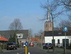 Skyline of Zoeterwoude | |
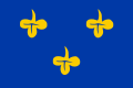 Flag  Coat of arms | |
.svg.png) Location in South Holland | |
| Coordinates: 52°8′N 4°30′E | |
| Country | Netherlands |
| Province | South Holland |
| Government | |
| • Body | Municipal council |
| • Mayor | Liesbeth Bloemen (CDA) |
| Area | |
| • Total | 21.96 km2 (8.48 sq mi) |
| • Land | 21.26 km2 (8.21 sq mi) |
| • Water | 0.70 km2 (0.27 sq mi) |
| Elevation | −2 m (−7 ft) |
| Population (January 2019)[4] | |
| • Total | 8,450 |
| • Density | 397/km2 (1,030/sq mi) |
| Time zone | UTC+1 (CET) |
| • Summer (DST) | UTC+2 (CEST) |
| Postcode | 2380–2382 |
| Area code | 071 |
| Website | www |
The municipality of Zoeterwoude consists of:
The main brewery of Heineken International is located in Zoeterwoude.
Topography

Dutch topographic map of Zoeterwoude, Sept. 2014. Click to enlarge.
History

The name Zoeterwoude is first mentioned in a document from 1205, which references a certain "Florentius van Sotrewold". It is uncertain if this is a reference to the village. The first confirmed existence is from 1276 when Dirk van Santhorst received the "Soetrewold" fiefdom from Floris V, Count of Holland.
Its municipal boundaries were set circa 1300. At that time it was one of the largest municipalities in the Netherlands, but later much land was annexed by surrounding cities, notably Leiden. In 1450, the first bridge between Leiderdorp and Zoeterwoude was built. In 1574, Zoeterwoude was burnt to the ground and its polders inundated by Leideners in order to increase the range of the city's cannons. Almost no inhabitants remained in Zoeterwoude.
Around 1650, Zoeterwoude had been almost rebuilt and 50 years later it was prospering. After 1800, Leiden started a long series of annexations, reducing the land area of Zoeterwoude.
In 1960, the A4 motorway was built and since 1966 it has been the municipal boundary between Leiden and Zoeterwoude.
Notable people of Zoeterwoude
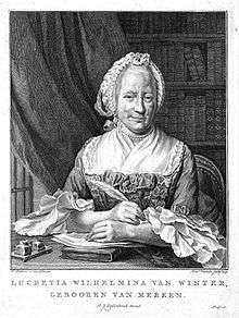
- Lucretia Wilhelmina van Merken (1721-1789), dramatist and poet
- Harm Kamerlingh Onnes (1893–1985), portrait painter and ceramist
- Paul van Kempen (1893–1955), violinist and conductor
- Bram van Velde (1895–1981), fine-art painter
- Aar de Goede (1928–2016) politician
Sport
- François Brandt (1874–1949) rower, competed at the 1900 Summer Olympics
- Jeroen Straathof (born 1972), cyclist and speed skater
- Suzanne de Goede (born 1984), cyclist
Gallery
 Zoeterwoude. Village view, as seen from the Watertje
 Weipoort, a stretched out neighbourhood within Zoeterwoude
%2C_Westbroekpolder.JPG) View over the Westbroekpolder near Zoeterwoude-Zuidbuurt
View over the Westbroekpolder near Zoeterwoude-Zuidbuurt%2C_Christina's_hoeve.JPG) Christina's farm in Westeinde
Christina's farm in Westeinde.JPG) Former monastery of the Franciscan Order, now a girls' school, in Zoeterwoude
Former monastery of the Franciscan Order, now a girls' school, in Zoeterwoude.JPG) Former shipyard in the old centre
Former shipyard in the old centre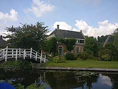 Noordbuurtseweg, Zoeterwoude
References
- "Collegeleden" [Members of the board] (in Dutch). Gemeente Zoeterwoude. Retrieved 30 August 2013.
- "Kerncijfers wijken en buurten" [Key figures for neighbourhoods]. CBS Statline (in Dutch). CBS. 2 July 2013. Retrieved 12 March 2014.
- "Postcodetool for 2381ET". Actueel Hoogtebestand Nederland (in Dutch). Het Waterschapshuis. Retrieved 30 August 2013.
- "Bevolkingsontwikkeling; regio per maand" [Population growth; regions per month]. CBS Statline (in Dutch). CBS. 1 January 2019. Retrieved 1 January 2019.
External links
| Wikimedia Commons has media related to Zoeterwoude. |
Places adjacent to Zoeterwoude | |
|---|---|

| Authority control |
|
|---|