Teylingen
Teylingen (Dutch pronunciation: [ˈtɛilɪŋə(n)] (![]()
Teylingen | |
|---|---|
.JPG) The Kagerplassen lake system in Teylingen | |
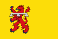 Flag  Coat of arms | |
.svg.png) Location in South Holland | |
| Coordinates: 52°13′N 4°29′E | |
| Country | Netherlands |
| Province | South Holland |
| Established | 1 January 2006[1] |
| Government | |
| • Body | Municipal council |
| • Mayor | Carla Breuer (CDA) |
| Area | |
| • Total | 33.49 km2 (12.93 sq mi) |
| • Land | 28.55 km2 (11.02 sq mi) |
| • Water | 4.94 km2 (1.91 sq mi) |
| Elevation | 0 m (0 ft) |
| Population (January 2019)[5] | |
| • Total | 37,061 |
| • Density | 1,298/km2 (3,360/sq mi) |
| Time zone | UTC+1 (CET) |
| • Summer (DST) | UTC+2 (CEST) |
| Postcode | 2170–2172, 2215, 2360–2362 |
| Area code | 0252, 071 |
| Website | www |
The municipality is bordered by Noordwijkerhout and Lisse to the north, Haarlemmermeer and Alkemade to the east, Leiderdorp and Leiden to the south, and Oegstgeest and Katwijk to the west. It is located in an area called the "Dune and Bulb Region" (Duin- en Bollenstreek). The Kagerplassen are to the east of Sassenheim.
Population centres
- Sassenheim - location of city hall
- Teijlingen, with Slot Teylingen
- Voorhout
- Warmond
Topography
 Dutch Topographic map of Teylingen, June 2015
Public transportation
Railway Leiden Centraal to Haarlem (part of line 10), with stations (municipalities in bold) and official station abbreviations:
|
Notable people
- Herman Boerhaave (1668 in Voorhout – 1738) a Dutch botanist, chemist, Christian humanist and physician
- Han Zuilhof (born 1965 in Sassenheim) the Chair of Organic Chemistry at Wageningen University
- Frank Ammerlaan (born 1979 in Sassenheim) a Dutch artist who lives and works in London
Sport
Bart Zoet, 1964
- Piet van der Lans (born 1940 in Sassenheim) a retired Dutch track cyclist, competed at the 1960 Summer Olympics
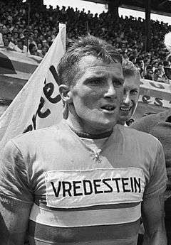
- Bart Zoet (1942 in Sassenheim – 1992) a Dutch cyclist, team gold medallist at the 1964 Summer Olympics
- Stan van Belkum (born 1961 in Warmond) a former water polo player, competed at the 1980 and 1984 Summer Olympics
- Rob van Dijk (born 1969 in Voorhout) a Dutch retired football goalkeeper with 364 club caps
- Edwin van der Sar (born 1970 in Voorhout) a Dutch retired football goalkeeper with 606 club caps
- Martin Hersman (born 1974 in Sassenheim) a retired speed skater, he competed at the 1994 and 1998 Winter Olympics
Image gallery
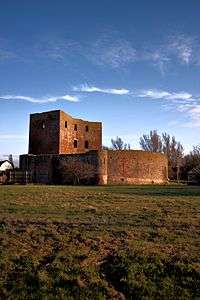 The ruins of Teylingen
 Beeld Lucas de Wit2 1994 Raadhuisplein Voorhout
_(27463681323).jpg) Kaag Sociëteit Kager plassen
Kaag Sociëteit Kager plassen Sassenheim, - panoramio
_(48731620981).jpg) Sailing on the Kaag, Warmond
Sailing on the Kaag, Warmond
References
- "Gemeentelijke indeling op 1 januari 2006" [Municipal divisions on 1 January 2006]. cbs.nl (in Dutch). CBS. Retrieved 24 August 2013.
- "Burgemeester" [Mayor] (in Dutch). Gemeente Teylingen. Archived from the original on 11 March 2013. Retrieved 24 August 2013.
- "Kerncijfers wijken en buurten" [Key figures for neighbourhoods]. CBS Statline (in Dutch). CBS. 2 July 2013. Retrieved 12 March 2014.
- "Postcodetool for 2215MA". Actueel Hoogtebestand Nederland (in Dutch). Het Waterschapshuis. Retrieved 24 August 2013.
- "Bevolkingsontwikkeling; regio per maand" [Population growth; regions per month]. CBS Statline (in Dutch). CBS. 1 January 2019. Retrieved 1 January 2019.
External links
| Wikimedia Commons has media related to Teylingen. |
Places adjacent to Teylingen | ||||||||||
|---|---|---|---|---|---|---|---|---|---|---|
| ||||||||||

| Authority control |
|
|---|
This article is issued from Wikipedia. The text is licensed under Creative Commons - Attribution - Sharealike. Additional terms may apply for the media files.