Waddinxveen
Waddinxveen (Dutch pronunciation: [ˌʋɑdɪŋksˈfeːn] (![]()
Waddinxveen | |
|---|---|
 Vertical-lift bridge over the Gouwe in Waddinxveen | |
 Flag  Coat of arms | |
.svg.png) Location in South Holland | |
| Coordinates: 52°3′N 4°39′E | |
| Country | Netherlands |
| Province | South Holland |
| Government | |
| • Body | Municipal council |
| • Mayor | Evert Jan Nieuwenhuis (SGP) |
| Area | |
| • Total | 29.40 km2 (11.35 sq mi) |
| • Land | 27.90 km2 (10.77 sq mi) |
| • Water | 1.50 km2 (0.58 sq mi) |
| Elevation | −2 m (−7 ft) |
| Population (January 2019)[4] | |
| • Total | 28,316 |
| • Density | 1,015/km2 (2,630/sq mi) |
| Demonym(s) | Waddinxvener |
| Time zone | UTC+1 (CET) |
| • Summer (DST) | UTC+2 (CEST) |
| Postcode | 2740–2743 |
| Area code | 0182 |
| Website | www |
In Waddinxveen, there's the so-called 'Vergeten Plek' (Dutch for 'Forgotten Place'). This is the lowest place in the Dutch polders. It's 7.01 meters below Amsterdam Ordnance Datum.
History
The first reference to the area is from 1233, when on April 20, Floris IV, Count of Holland, sold an area of peat lands along the Gouwe River for 200 Dutch pounds to Nicolas of Gnepwijk, Lord of Aalsmeer and Woubrecht. The area was given the name "Waddinxvene". Because of this event, Waddinxveen celebrated its 750-year anniversary in 1983.
Between 1817 and 1870, Waddinxveen was dissolved and its area split into the municipalities of Noord-Waddinxveen and Zuid-Waddinxveen.[5] Due to further expanding, those two municipalities reunited into one.
Topography
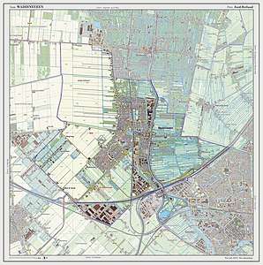 Dutch Topographic map of Waddinxveen, July 2013
Notable people

- Mark Vanderloo (born 1968) a Dutch model[6]
- Pepijn van den Nieuwendijk (born 1970) a Dutch painter and ceramist
- Sharon den Adel (born 1974) a songwriter, fashion designer and lead vocalist with the Dutch symphonic metal band Within Temptation
- Robert Westerholt (born 1975) a Dutch musician, guitarist and co-founder of the symphonic metal band Within Temptation
- Martijn Westerholt (born 1979) keyboardist, songwriter and cofounder of the Dutch symphonic metal band Delain
Sport
- Tjark de Vries (born 1965) a Dutch rower, competed at the 1988 Summer Olympics
- Mirjam Overdam (born 1973) a Dutch female water polo team player, competed at the 2000 Summer Olympics
- Roald van Hout (born 1988) a Dutch former footballer with over 180 club caps
Gallery
 Kerkweg-Oost, Waddinxveen
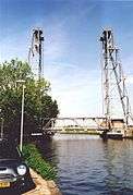 Lift bridge at Waddinxveen crossing the Gouwe
 Plasweg, Waddinxveen. De Schouw
 The Hefbrug church
References
- "Samenstelling college" [Members of the board] (in Dutch). Gemeente Waddinxveen. Archived from the original on 4 November 2013. Retrieved 26 August 2013.
- "Kerncijfers wijken en buurten" [Key figures for neighbourhoods]. CBS Statline (in Dutch). CBS. 2 July 2013. Retrieved 12 March 2014.
- "Postcodetool for 2741HR". Actueel Hoogtebestand Nederland (in Dutch). Het Waterschapshuis. Retrieved 26 August 2013.
- "Bevolkingsontwikkeling; regio per maand" [Population growth; regions per month]. CBS Statline (in Dutch). CBS. 1 January 2019. Retrieved 1 January 2019.
- Ad van der Meer and Onno Boonstra, Repertorium van Nederlandse gemeenten, KNAW, 2006, p. 191 (Online edition Archived 2012-03-25 at the Wayback Machine)
- IMDb Database retrieved 30 December 2019
External links
Places adjacent to Waddinxveen | ||||||||||
|---|---|---|---|---|---|---|---|---|---|---|
| ||||||||||

| Authority control |
|
|---|