Somogy County
Somogy (Hungarian: Somogy megye, pronounced [ˈʃomoɟ]; Croatian: Šomođska županija; Slovene: Šomodska županija, German: Komitat Schomodei) is an administrative county (comitatus or megye) in present Hungary, and also in the former Kingdom of Hungary.
Somogy County Somogy megye | |
|---|---|
   | |
 Flag  Coat of arms | |
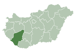 Somogy County within Hungary | |
| Country | |
| Region | Southern Transdanubia |
| County seat | Kaposvár |
| Districts | |
| Government | |
| • President of the General Assembly | Norbert Bíró (Fidesz-KDNP) |
| Area | |
| • Total | 6,065.07 km2 (2,341.74 sq mi) |
| Area rank | 5th in Hungary |
| Population (2015) | |
| • Total | 312,084[1] |
| • Rank | 13th in Hungary |
| Postal code | 7253 – 729x, 74xx – 75xx, 7918, 7977 – 7979, 86xx – 873x, 884x – 885x |
| Area code(s) | (+36) 82, 84, 85 |
| ISO 3166 code | HU-SO |
| Website | www |
Somogy County
Somogy County lies in south-western Hungary, on the border with Croatia. It stretches between the river Dráva and the southern shore of Lake Balaton. It shares borders with the Hungarian counties of Zala, Veszprém, Fejér, Tolna, and Baranya. It is the most sparsely populated county in Hungary. The capital of Somogy County is Kaposvár. Its area is 6,036 km².
History
Somogy was also the name of a historic administrative county (comitatus) of the Kingdom of Hungary. Its territory, which was slightly larger than that of present Somogy County, is now in south-western Hungary. The capital of the county was and still is Kaposvár.

Demographics
Religion in Somogy County (2011 census)
In 2015, it had a population of 312,084 and the population density was 52/km².
| Year | County population[2] | Change |
|---|---|---|
| 1949 | 361,213 | n/a |
| 1960 | 1.93% | |
| 1970 | -3.03% | |
| 1980 | 0.91% | |
| 1990 | -4.32% | |
| 2001 | -2.75% | |
| 2011 | -5.70% |
Ethnicity
Besides the Hungarian majority, the main minorities are the Roma (approx. 16,000), Germans (3,000) and Croats (1,500).
Total population (2011 census): 316,137
Ethnic groups (2011 census):[3]
Identified themselves: 287,692 persons:
- Hungarians: 265,464 (92,27%)
- Gypsies: 16,167 (5,62%)
- Germans: 3,039 (1,06%)
- Others and indefinable: 3,022 (1,05%)
- Approx. 46,000 persons in Somogy County did not declare their ethnic group at the 2011 census.
Religion
Religious adherence in the county according to 2011 census:[4]
- Catholic – 168,307 (Roman Catholic – 167,719; Greek Catholic – 546);
- Reformed – 21,176;
- Evangelical – 5,807;
- other religions – 3,829;
- Non-religious – 35,503;
- Atheism – 3,056;
- Undeclared – 78,459.
Regional structure

| № | English and Hungarian names |
Area (km²) |
Population (2011) |
Density (pop./km²) |
Seat | № of municipalities |
| 1 | Barcs District Barcsi járás |
696.47 | 23,793 | 34 | Barcs | 26 |
| 2 | Csurgó District Csurgói járás |
496.19 | 16,862 | 34 | Csurgó | 18 |
| 3 | Fonyód District Fonyódi járás |
645.44 | 33,785 | 52 | Fonyód | 21 |
| 4 | Kaposvár District Kaposvári járás |
1,591.36 | 118,496 | 74 | Kaposvár | 78 |
| 5 | Marcali District Marcali járás |
904.24 | 34,472 | 38 | Marcali | 37 |
| 6 | Nagyatád District Nagyatádi járás |
647.07 | 26,003 | 40 | Nagyatád | 18 |
| 7 | Siófok District Siófoki járás |
657.05 | 51,099 | 78 | Siófok | 24 |
| 8 | Tab District Tabi járás |
427.24 | 12,797 | 30 | Tab | 24 |
| Somogy County | 6,065.07 | 312,084 | 52 | Kaposvár | 245 | |
|---|---|---|---|---|---|---|
Politics

The Somogy County Council, elected at the 2014 local government elections, is made up of 16 counselors, with the following party composition:[5]
| Party | Seats | Current County Assembly | |||||||||
|---|---|---|---|---|---|---|---|---|---|---|---|
| Fidesz-KDNP | 9 | ||||||||||
| Movement for a Better Hungary (Jobbik) | 3 | ||||||||||
| Association for Somogy (Somogyért) | 2 | ||||||||||
| Hungarian Socialist Party (MSZP) | 1 | ||||||||||
| Democratic Coalition (DK) | 1 | ||||||||||
Presidents of the General Assembly
| List of Presidents, from 1990[6] | |
|---|---|
| István Gyenesei (Independent) | 1990–1994 |
| István Kolber (MSZP) | 1994–1998 |
| István Gyenesei (Somogyért) | 1998–2006 |
| Attila Gelencsér (Fidesz-KDNP) | 2006–2014 |
| Norbert Bíró (Fidesz-KDNP) | 2014– |
Municipalities
Somogy County has 1 urban county, 15 towns, 2 large villages and 227 villages.
- City with county rights
(ordered by population, as of 2011 census)
- Kaposvár (66,245) – county seat
- Towns
- Siófok (25,045)
- Marcali (11,736)
- Barcs (11,420)
- Nagyatád (11,032)
- Balatonboglár (5,736)
- Balatonlelle (5,217)
- Csurgó (5,214)
- Fonyód (4,793)
- Tab (4,533)
- Nagybajom (3,330)
- Lengyeltóti (3,050)
- Kadarkút (2,653)
- Zamárdi (2,386)
- Balatonföldvár (2,207)
- Igal (1,270)
- Villages
- Alsóbogát
- Andocs
- Ádánd
- Babócsa
- Bábonymegyer
- Bakháza
- Balatonberény
- Balatonendréd
- Balatonfenyves
- Balatonkeresztúr
- Balatonmáriafürdő
- Balatonőszöd
- Balatonszabadi
- Balatonszárszó

- Balatonszemes
- Balatonszentgyörgy
- Balatonújlak
- Bárdudvarnok
- Baté
- Bálványos
- Bedegkér
- Bélavár
- Beleg
- Berzence
- Bodrog
- Bolhás
- Bolhó
- Bonnya
- Böhönye
- Bőszénfa
- Buzsák
- Büssü
- Csákány
- Cserénfa
- Csokonyavisonta
- Csoma
- Csömend
- Csököly
- Csombárd
- Csurgónagymarton
- Darány
- Drávagárdony
- Drávatamási
- Ecseny
- Edde
- Felsőmocsolád
- Fiad
- Fonó
- Főnyed
- Gadács
- Gadány
- Gamás
- Gálosfa
- Gige
- Gölle
- Gyékényes
- Görgeteg
- Gyugy
- Hajmás
- Hács
- Háromfa
- Hedrehely
- Hencse
- Heresznye
- Hetes
- Hollád
- Homokszentgyörgy
- Hosszúvíz
- Iharos
- Iharosberény
- Inke
- Istvándi
- Jákó
- Juta
- Kapoly
- Kaposfő
- Kaposgyarmat
- Kaposhomok
- Kaposkeresztúr
- Kaposmérő
- Kaposszerdahely
- Kaposújlak
- Karád
- Kastélyosdombó
- Kaszó
- Kazsok
- Kálmáncsa
- Kánya
- Kára
- Kelevíz
- Kercseliget
- Kereki
- Kéthely
- Kisasszond
- Kisbajom
- Kisberény
- Kisbárapáti
- Kisgyalán
- Kiskorpád
- Komlósd
- Kötcse
- Kőröshegy
- Kőkút
- Kutas
- Lábod
- Lad
- Lakócsa
- Látrány
- Libickozma
- Lulla
- Magyaratád
- Magyaregres
- Mernye
- Mesztegnyő
- Mezőcsokonya
- Mike
- Miklósi
- Mosdós
- Nagyberki
- Nagyberény
- Nagycsepely
- Nagykorpád
- Nagyszakácsi
- Nágocs
- Nemesdéd
- Nemeskisfalud
- Nemesvid
- Nikla
- Nyim
- Orci
- Ordacsehi
- Osztopán
- Öreglak
- Ötvöskónyi
- Őrtilos
- Pamuk
- Patalom
- Patca
- Patosfa
- Pálmajor
- Péterhida
- Pogányszentpéter
- Polány
- Porrog
- Porrogszentkirály
- Porrogszentpál
- Potony
- Pusztakovácsi
- Pusztaszemes
- Ráksi
- Rinyabesenyő
- Rinyakovácsi
- Rinyaszentkirály
- Rinyaújlak
- Rinyaújnép
- Ságvár
- Sántos
- Sávoly
- Segesd
- Sérsekszőlős
- Siójut
- Som
- Somodor
- Somogyacsa
- Somogyaracs
- Somogyaszaló
- Somogybabod
- Somogybükkösd
- Somogycsicsó
- Somogydöröcske
- Somogyegres
- Somogyfajsz
- Somogygeszti
- Somogyjád
- Somogymeggyes
- Somogysimonyi
- Somogyszentpál
- Somogyszil
- Somogyszob
- Somogysámson
- Somogysárd
- Somogytúr
- Somogyudvarhely
- Somogyvámos
- Somogyvár
- Somogyzsitfa
- Szabadi
- Szabás
- Szántód
- Szegerdő
- Szenna
- Szenta
- Szentbalázs
- Szentborbás
- Szentgáloskér
- Szenyér
- Szilvásszentmárton
- Szorosad
- Szólád
- Szőkedencs
- Szőlősgyörök
- Szulok
- Tapsony
- Tarany
- Taszár
- Táska
- Tengőd
- Teleki
- Tikos
- Torvaj
- Tótújfalu
- Törökkoppány
- Újvárfalva
- Várda
- Varászló
- Vése
- Visnye
- Visz
- Vízvár
- Vörs
- Zala
- Zákány
- Zics
- Zimány
- Zselickisfalud
- Zselickislak
- Zselicszentpál
![]()
See also
- List of tourist attractions in Somogy County
- Slovenes in Somogy
Gallery
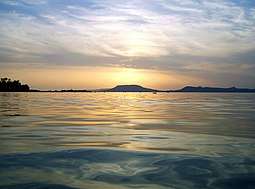
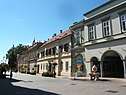
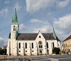 Kaposvár, the capital of the county
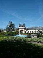 Siófok, the Capital of Balaton
 Kőröshegy Viaduct in Kőröshegy
 House of József Rippl-Rónai
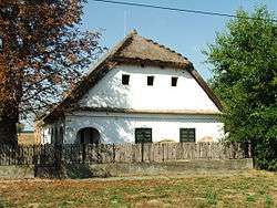 Traditional Hungarian house in Istvándi
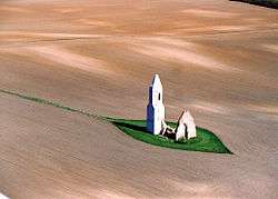 Pusztatemplom of the Árpád era near Somogyvámos
International relations
Somogy County has a partnership relationship with:
|
References
| Wikimedia Commons has media related to Somogy County. |
| Wikivoyage has a travel guide for Somogy County. |
- nepesseg.com, population data of Hungarian settlements
- népesség.com, "Somogy megye népessége 1870-2015"
- 1.1.6. A népesség anyanyelv, nemzetiség és nemek szerint – Frissítve: 2013.04.17.; Hungarian Central Statistical Office (in Hungarian)
- 2011. ÉVI NÉPSZÁMLÁLÁS, 3. Területi adatok, 3.15 Somogy megye, (in Hungarian)
- Közgyűlés, (in Hungarian)
- Önkormányzati választások eredményei (in Hungarian)
- kaposvarmost.hu - TOVÁBBI LEHETŐSÉGEKET KERES SOMOGY ÉS GANSU - July 2, 2016
External links
| Authority control |
|
|---|