Letenye District
Letenye (Hungarian: Letenyei járás) is a district in south-western part of Zala County. Letenye is also the name of the town where the district seat is found. The district is located in the Western Transdanubia Statistical Region.
Letenye District Letenyei járás | |
|---|---|
 Coat of arms | |
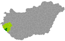 Letenye District within Hungary and Zala County. | |
| Country | |
| County | Zala |
| District seat | Letenye |
| Area | |
| • Total | 388.69 km2 (150.07 sq mi) |
| Area rank | 5th in Zala |
| Population (2011 census) | |
| • Total | 16,410 |
| • Rank | 5th in Zala |
| • Density | 42/km2 (110/sq mi) |
Geography
Letenye District borders with Lenti District to the northwest, Zalaegerszeg District to the north, Nagykanizsa District to the east, the Croatian county of Međimurje and Slovenia to the southwest. The number of the inhabited places in Letenye District is 27.
Municipalities
The district has 1 town and 26 villages. (ordered by population, as of 1 January 2013)[1]
- Bánokszentgyörgy (650)
- Bázakerettye (861)
- Becsehely (2,080)
- Borsfa (736)
- Bucsuta (227)
- Csörnyeföld (420)
- Kerkaszentkirály (228)
- Kiscsehi (170)
- Kistolmács (181)
- Lasztonya (86)
- Letenye (4,202) – district seat
- Lispeszentadorján (289)
- Maróc (76)
- Molnári (718)
- Murarátka (245)
- Muraszemenye (626)
- Oltárc (283)
- Petrivente (362)
- Pusztamagyaród (576)
- Semjénháza (601)
- Szentliszló (281)
- Szentmargitfalva (85)
- Tótszentmárton (840)
- Tótszerdahely (1,096)
- Valkonya (55)
- Várfölde (191)
- Zajk (248)
The bolded municipality is city.
See also
- List of cities and towns in Hungary
References
- "A KSH 2013. évi helységnévkönyve". ksh.hu. Retrieved 2017-10-27.
This article is issued from Wikipedia. The text is licensed under Creative Commons - Attribution - Sharealike. Additional terms may apply for the media files.