Yu Shan
Yu Shan or Yushan, also known as Mount Jade, Jade Mountain, or Mount Yu, is the highest mountain on Taiwan at 3,952 m (12,966 ft) above sea level, giving Taiwan the 4th-highest maximum elevation of any island in the world. It is the highest point in the western Pacific region outside of the Kamchatka Peninsula. Yushan and surrounding mountains belong to Yushan Range. The area was once in the ocean; it rose to its current height because of the Eurasian Plate's movement over the Philippine Sea Plate.
| Yushan | |
|---|---|
| Jade Mountain | |
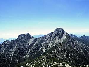 Yushan from the North Peak | |
| Highest point | |
| Elevation | 3,952 m (12,966 ft) |
| Prominence | 3,952 m (12,966 ft) Ranked 27th |
| Isolation | 1,815 km (1,128 mi) |
| Listing | Country high point Ultra 100 Peaks of Taiwan |
| Coordinates | 23°28′12″N 120°57′26.16″E |
| Geography | |
 Yushan The location of Yushan (Yushan National Park) | |
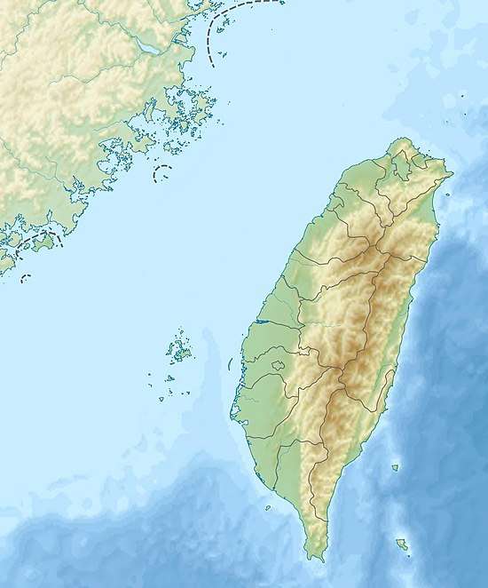
| Location | The border on Taoyuan District, Kaohsiung/ Alishan, Chiayi County/ Xinyi, Nantou County, Taiwan |
| Parent range | Yushan Range |
| Climbing | |
| First ascent | 1898 by German explorer Karl Theodor Stöpel |
| Easiest route | Maintained trail, snow/ice climb during some winter months |
| Yushan | |||||||||||||||||||
|---|---|---|---|---|---|---|---|---|---|---|---|---|---|---|---|---|---|---|---|
| Chinese | 玉山 | ||||||||||||||||||
| Postal | Mount Morrison | ||||||||||||||||||
| Literal meaning | Jade Mountain | ||||||||||||||||||
| |||||||||||||||||||
| Former names | |||||||||||||||
|---|---|---|---|---|---|---|---|---|---|---|---|---|---|---|---|
| Batongguan | |||||||||||||||
| Traditional Chinese | 八通關 | ||||||||||||||
| Simplified Chinese | 八通关 | ||||||||||||||
| Literal meaning | transcribing the Tsou name Patungkuanu | ||||||||||||||
| |||||||||||||||
| Baiyushan | |||||||||||||||
| Chinese | 白玉山 | ||||||||||||||
| Literal meaning | White Jade Mountain | ||||||||||||||
| |||||||||||||||
| Xueshan | |||||||||||||||
| Chinese | 雪山 | ||||||||||||||
| Literal meaning | Snowy Mountain | ||||||||||||||
| |||||||||||||||
| Mugangshan | |||||||||||||||
| Traditional Chinese | 木岡山 | ||||||||||||||
| Simplified Chinese | 木冈山 | ||||||||||||||
| Literal meaning | Wooded Mountain | ||||||||||||||
| |||||||||||||||
| Mount Niitaka | |||||||||
|---|---|---|---|---|---|---|---|---|---|
| Chinese name | |||||||||
| Chinese | 新高山 | ||||||||
| Literal meaning | New High Mountain | ||||||||
| |||||||||
| Japanese name | |||||||||
| Kanji | 新高山 | ||||||||
| Hiragana | にいたかやま | ||||||||
| |||||||||
The mountains are now protected as the Yushan National Park. The national park is Taiwan's largest, highest and least accessible national park. It contains the largest tract of wilderness remaining in Taiwan and is also valued for its pristine forests and faunal diversity, including many endemic species. On July 21, 2009, Yushan was elected one of 28 finalists in the New7Wonders of Nature voting campaign. It even had held the top position in the “Mountains and Volcanoes” category on the list of first round voting of the 77 nominees ended on July 7, 2009.
Names
Yushan or Yu Shan is the pinyin romanization of the Chinese name 玉山. It is also known as Mount Yu, Mount Jade, and Jade Mountain, calques of the same name. The name derives from its appearance in the winter, when its thick snow cover is thought to make its peak look like stainless jade.[1] "Yushan" or Jade Mountain was also the name of a location in ancient Chinese mythology, a paradise said to be the home of the Queen Mother of the West.
During the Qing Dynasty, Yushan was known in Chinese as Mugangshan ("Wooded Mountain") from its surrounding forests.[2] Other Chinese names included Batongguan, transcribing its native Tsou name "Patungkuonʉ"; Baiyushan ("White Jade Mountain"); and Xueshan ("Snowy Mountain").[1] It was previously known in English as Mount Morrison,[3] a name sometimes mistakenly thought to honor the missionary Robert Morrison, but actually simply the name of an American captain who sighted it.[2]
Other native names for the mountain include Saviah and Tongku Saveq (Bunun; the latter means "highest peak"), Tanungu'incu (Kanakanavu), and Kanasian (Paiwan).
During Japan's rule in Taiwan, the mountain became known as Mount Niitaka or Niitakayama ("New High Mountain") because new surveying showed that it was 176 m (577 ft) higher than Mount Fuji in the Japanese Islands.[3]
Geography and geology
The island of Taiwan is situated at the intersection of two tectonic plates – the Eurasian Plate and the Philippine Sea Plate. Even as “recently” as the late Paleozoic (some 250 million years ago), the land here was still but a sedimentary seabed layered with silt and sand. As the two plates began pressing against each other, the land buckled, bent, and created the landscape – 165 mountains higher than 3,000 m (9,800 ft) above sea level on a relatively small island (38th largest in the world).
Yushan is also notable in containing the highest point on the Tropic of Cancer and the only point on that circle of latitude where there is any evidence of Quaternary glaciation.[4] As recently as seventeen thousand years ago, permanent ice caps existed throughout Taiwan's highest mountains and extended owing to the wet climate down to 2,800 m (9,190 ft); whereas currently the nearest glaciers to the Tropic of Cancer are in Mexico on the Iztaccíhuatl volcano.
The ocean waters off Taiwan's east coast are deep; in fact, submarine slopes plunge down to the Pacific Ocean at a grade of 1:10 and the ocean reaches a depth of more than 4,000 m (13,100 ft) about 50 km (30 mi) from the coast.[5]
Hiking
With panoramic views, overlapping mountains, and deep, plunging valleys, Yushan National Park is well known for its scenery, sunrises, sunsets, geological features, and views of the clouds from above. Sea of clouds often fill the valleys. Indisputably, Yushan itself is the focal point of the park.
Yushan is one of the favorites among Taiwanese mountain climbers. International peak baggers Yushan is ranked as the 4th World Island Highpoints and the 3rd Asian Island Highpoints. After Puncak Jaya (4,884 m [16,024 ft]) in Indonesia and Mount Kinabalu (4,095 m [13,435 ft]) in Malaysia to form an "Asian Trilogy" hiking experience.[6][7]
Yushan has five main peaks with the Main Peak being the most popular:
- Main Peak (玉山主峰), 3,952 m (12,966 ft)
- Eastern Peak (玉山東峰), 3,869 m (12,694 ft) – 1.2 km (0.7 mi) from Main Peak
- Northern Peak (玉山北峰), 3,858 m (12,657 ft) – 2.2 km (1.4 mi) from Wind Tunnel (風口)
- Southern Peak (玉山南峰), 3,844 m (12,612 ft) – 3.1 km (1.9 mi) from Paiyun Lodge (排雲山莊)
- Western Peak (玉山西峰), 3,467 m (11,375 ft) – 4 km (2.5 mi) from Paiyun Lodge (排雲山莊)
The east, west, north, and south peaks surround the main summit. The east peak rises to a height of 3,869 m (12,694 ft) and is considered one of Taiwan's Ten Major Summits (十峻). The south peak is a sharp pinnacle of black shale. The relatively accessible west side of Yushan is covered with thick forests. The north peak is part of a long, gently-rising ridge; this peak consists of two high points that resemble a camel's humps. The North Peak is also home to Taiwan's highest permanently occupied building, the Yushan Weather Station, where the occasional visitors are given a warm welcome.
 Sea of Clouds at Yushan
 Sunrise at Yushan
 Sea of Clouds on Yushan Trail
Flora and fauna
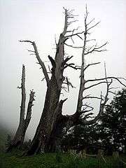
-PeterWen-6.jpg)
Taiwan, with the tropic of Cancer across the center of the island, has a climate between tropical and subtropical. The average temperature is 23.5 °C (74.3 °F). Here low elevation areas support evergreen broadleaved forests. As elevation increases, evergreen broadleaved forests are gradually replaced by deciduous forests and coniferous forests. At mountain peaks with alpine conditions, only mosses, liverworts and occasionally grasses can be found on the ground.[8]
All of the above vegetation variations can be seen in the Yushan area from low foothills to high summits with an elevation difference of 3.6 km (2.2 mi). Because of this wide climatic and vegetation variations, this environment nurtures the richest and most diversified wildlife in Taiwan. Preliminary investigations reveal that there are 130 species of birds, 28 species of mammals, 17 species of reptiles, 12 species of amphibians and 186 species of butterflies in Yushan National Park. In fact, Yushan is nicknamed "the ark" by academics who see it as a repository of Taiwan's rare species. It is almost an encyclopedia of Taiwan's ecological systems, a geological museum and an important habitat of one-third of Taiwan's endemic species, such as:
- Formosan serow (台灣長鬃山羊)
- Reeves's muntjac (台灣山羌)
- Formosan black bear (台灣黑熊)
- Formosan blue magpie (台灣藍鵲)
- Formosan rock macaque (台灣獼猴)
- Hemimyzon taitungensis (台東間爬岩鰍) and Varicorhinus tamusuiensis (Oshima) – Two unique fish species living in the Lekuleku River area.
History
Under the Qing Dynasty, W. Morrison, captain of the American steam freighter Alexander, sighted the mountain while departing from Anping Harbor (present-day Anping, Tainan) in 1857. His log was the first western mention of the mountain, which took his name in European accounts.[2][9]
Under the Japanese, the anthropologists Torii Ryūzō and Ushinosuke Mori became the first people recorded to summit the mountain in 1900.
In 1900, during Japanese rule, two Japanese anthropologists, became the first people to have been recorded ascending the mountain. They gave it the name "Mount Niitaka", which was used as the name of the Niitaka Arisan National Park (新高阿里山国立公園) in 1937. The Imperial Japanese Navy also used the mountain's name in its signal—Niitakayama Nobore (ニイタカヤマノボレ) or "Climb Mount Niitaka"—to begin the surprise attack against the USN Pacific Fleet and its base at Pearl Harbor, Hawaii, on 7 December 1941.[10]
Under the Republic of China, a large bronze statue of Yu Youren was placed on the Yushan summit in 1966. The statue was cut down and thrown into a ravine by activists for Taiwan independence in 1996.[11]
In recent years, Yushan has played an important role in a new focus on Taiwan's identity. Because of its iconic status, Yushan has been chosen to be the background of the newly-issued NT$1,000 notes on 20 July 2005.[12] Similarly, a newly-found asteroid by Lulin Observatory of National Central University was named after Yushan on 28 December 2007.[13]
Climate
Yushan has an alpine climate (Köppen ET). The tip of Yushan is usually covered with frost from November to March. Elevations above 2,000 metres (6,562 ft) may sometimes see snow during the winter months, and there are four consecutive months of snow accumulation at places with elevations higher than 3,000 metres (9,843 ft). The first snow may appear in October and completely melts by May. Snow falls 24.3 days per year on average on Yushan, and the number is gradually decreasing. Yushan receives around 3,600 mm (141.7 in) of precipitation annually. It rains an average of 140 days per year, mostly between May and August. From May until the first part of June is plum rain season or monsoon season. Taiwan's typhoon season roughly falls between July and September. The peak month is in August, which sees 520 mm (20.5 in) of precipitation on average, compared to 70 mm (2.8 in) in December, the driest month.
| Climate data for Yushan (normals 1981–2010, extremes 1943–present) | |||||||||||||
|---|---|---|---|---|---|---|---|---|---|---|---|---|---|
| Month | Jan | Feb | Mar | Apr | May | Jun | Jul | Aug | Sep | Oct | Nov | Dec | Year |
| Record high °C (°F) | 17.9 (64.2) |
17.0 (62.6) |
18.5 (65.3) |
18.9 (66.0) |
20.1 (68.2) |
21.3 (70.3) |
21.8 (71.2) |
21.3 (70.3) |
22.0 (71.6) |
21.7 (71.1) |
20.2 (68.4) |
16.8 (62.2) |
22.0 (71.6) |
| Average high °C (°F) | 3.7 (38.7) |
3.7 (38.7) |
5.4 (41.7) |
7.8 (46.0) |
10.6 (51.1) |
12.1 (53.8) |
13.8 (56.8) |
13.6 (56.5) |
13.0 (55.4) |
13.2 (55.8) |
10.2 (50.4) |
6.2 (43.2) |
9.4 (48.9) |
| Daily mean °C (°F) | −1.1 (30.0) |
−0.5 (31.1) |
1.1 (34.0) |
3.4 (38.1) |
5.7 (42.3) |
7.1 (44.8) |
7.9 (46.2) |
7.8 (46.0) |
7.1 (44.8) |
6.5 (43.7) |
4.0 (39.2) |
0.8 (33.4) |
4.2 (39.6) |
| Average low °C (°F) | −4.5 (23.9) |
−3.7 (25.3) |
−1.9 (28.6) |
0.4 (32.7) |
2.6 (36.7) |
4.2 (39.6) |
4.4 (39.9) |
4.4 (39.9) |
3.8 (38.8) |
2.6 (36.7) |
0.3 (32.5) |
−2.7 (27.1) |
0.8 (33.4) |
| Record low °C (°F) | −18.4 (−1.1) |
−14.5 (5.9) |
−15.2 (4.6) |
−9.8 (14.4) |
−3.3 (26.1) |
−1.9 (28.6) |
−0.6 (30.9) |
−0.4 (31.3) |
−1.3 (29.7) |
−5.5 (22.1) |
−10.6 (12.9) |
−15.0 (5.0) |
−18.4 (−1.1) |
| Average precipitation mm (inches) | 83.1 (3.27) |
120.5 (4.74) |
139.1 (5.48) |
244.4 (9.62) |
414.0 (16.30) |
488.2 (19.22) |
445.6 (17.54) |
519.3 (20.44) |
325.2 (12.80) |
144.3 (5.68) |
77.6 (3.06) |
70.0 (2.76) |
3,071.3 (120.92) |
| Average precipitation days (≥ 0.1 mm) | 7.2 | 7.1 | 8.6 | 14.6 | 18.5 | 18.6 | 17.2 | 18.4 | 16.0 | 11.0 | 7.7 | 5.6 | 150.5 |
| Average relative humidity (%) | 64.2 | 73.8 | 78.5 | 82.0 | 80.9 | 82.1 | 77.0 | 81.0 | 79.9 | 70.0 | 65.5 | 61.2 | 74.7 |
| Mean monthly sunshine hours | 202.4 | 146.8 | 150.0 | 132.1 | 139.7 | 132.5 | 177.2 | 160.4 | 152.3 | 207.2 | 203.9 | 203.5 | 2,008 |
| Source: Central Weather Bureau[14] | |||||||||||||
Gallery
.jpg) Yushan (玉山) during winter season
Yushan (玉山) during winter season.jpg) Yushan (玉山) during winter season
Yushan (玉山) during winter season Yushan (玉山) during winter season
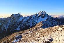 Yushan (玉山) during winter season
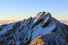 Yushan (玉山) during winter season
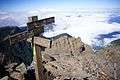 Yushan Trail signage
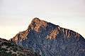 Yushan (玉山)
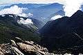 Laonung River at the northeastern side of Yushan
 Sea of clouds on Yushan Trail
 Sea of clouds on Yushan Trail
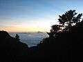 Sea of clouds on Yushan Trail
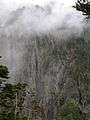 Sea of clouds near Tatajia Anbu on Yushan Trail
_in_the_morning.jpg) Mountain in the morning
Mountain in the morning Sunrise at Yushan
 Sunrise at Yushan
 Sunrise at Yushan
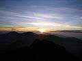 Sunrise at Yushan
_with_sun_set.jpg) Mountain with sunset
Mountain with sunset Hikers at the summit
 Formosan rock macaque found on Yushan Trail
.jpg) Yushan Range, eastern side view
Yushan Range, eastern side view Yushan on November 1, 1935
 Painting of Yushan by Nasu Masaki (那須雅城)
See also
References
Citations
- Han Cheung (November 25, 2018). "Taiwan in Time: Great Floods, an Imperial Edict, and a Defaced Statue". Taipei Times. Retrieved November 25, 2018.
- EB (1879), p. 415.
- Chamberlain & al. (1903), p. 554.
- Late Pleistocene to Early Holocen Glacial Landforms of Yushan Area, Taiwan
- Central Geological Survey, MOEA. Archived May 24, 2011, at the Wayback Machine
- "World Island Highpoints above 3000m". World Island Highpoints above 3000m. Retrieved November 20, 2017.
- Yushan
- Flora of China
- Cheng, Zoe (March 1, 2007), "Taiwan Looks for Its Roots", Taiwan Today, Taiwan: ROC Ministry of Foreign Affairs.
- MacDonald, Scot (October 1962). Evolution of Aircraft Carriers – the Japanese Developments (PDF). Naval Historical Center, Washington Navy Yard, DC. Retrieved August 10, 2006.
- 1.
- Bulletin Board of Central Bank of the Republic of China.
- Yushan Asteroid. Archived September 1, 2009, at the Wayback Machine
- "Climate Statistics–Monthly Mean". Central Weather Bureau. Retrieved March 1, 2015.
Bibliography
- , Encyclopaedia Britannica, 9th ed., Vol. IX, New York: Charles Scribner's Sons, 1879, pp. 415–17.
- Chamberlain, Basil Hall; et al. (1903), A Handbook for Travellers in Japan (7th ed.), London: J. Murray, OL 25302448M.
External links
| Wikimedia Commons has media related to Yushan. |
| Wikivoyage has a travel guide for Yushan. |