Woughton (parish)
Woughton (/ˈwʊftən/ WUUF-tən) is a civil parish[2][3] in south central Milton Keynes, ceremonial county of Buckinghamshire, England.
| Woughton | |
|---|---|
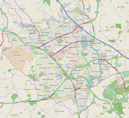 Woughton Mapping © OpenStreetMap 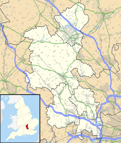 Woughton Location within Buckinghamshire | |
| Population | 13,774 (2011 Census)[1] |
| OS grid reference | SP876369 |
| Civil parish |
|
| Unitary authority |
|
| Ceremonial county | |
| Region | |
| Country | England |
| Sovereign state | United Kingdom |
| Post town | MILTON KEYNES |
| Postcode district | MK6 |
| Dialling code | 01908 |
| Police | Thames Valley |
| Fire | Buckinghamshire |
| Ambulance | South Central |
| UK Parliament | |
| Website | woughtoncommunitycouncil.gov.uk |
The parish takes its name from the original ecclesiastic parish of Woughton and the village of Woughton on the Green. It was reduced in size in 2012 when an area in the east of the parish, including the village of Woughton Green, became the separate parish of Old Woughton.
Geography and settlements of the parish
The current boundaries of the parish run from the Netherfield Roundabout (H8/V8), south along the V8 (Marlborough Street) to the roundabout (H9/V8), then west along the Groveway H9 until it reaches the intersection with the A5. It broadly follows the line of the A5 north until it passes underneath Chafron Way H7. It then runs east along the H7 before returning to the Netherfield Roundabout (H8/V8).
The parish comprises the communities of Beanhill, Coffee Hall, Eaglestone, Leadenhall, Netherfield, Peartree Bridge and Tinkers Bridge. Additionally, there are two industrial areas: Bleak Hall and Redmoor.
Beanhill
The building of the Beanhill area of Milton Keynes started in 1973/1974 during a strike by brick makers. Hence phase one was constructed with timber frames with corrugated cladding. The later phase two bungalows are brick-built. From the original build, with the exception of the roads Capron and Simnel (which have two-storey houses), the rest of the residential buildings were all bungalows. After construction every new home came with a tree voucher from The Milton Keynes Development Corporation, known then as the MKDC. More recently, more roads and buildings have been slotted in. For example, where Bracken House now stands there was originally allotments. In 1989 phase three introduced 35 shared ownership homes in the Wheatcroft Close area.
In keeping with the 1970s Milton Keynes culture there were various arts projects within the Beanhill community. Notably the underpass painted in the Wizard of Oz theme, which was between Beanhill and Coffee Hall, at the back of Lammas. Also the Toadstools, created by Sue McFarland, on the field behind Simnel, they are still there. In Beanhill's very early days there was also a street theatre based there called The Beanhill Flat Earth Society. They performed around MK.
Currently Beanhill benefits from local shops, a meeting place, a medical centre, and a first school and a nursery, both called Moorlands, although on different sites.
Bleak Hall
This district, next to the West Coast Main Line, is dedicated to light industry, construction industry supply and 'big shed' retail. The name Bleak Hall derives from a nearby farm. The streets of Bleak Hall are named after characters and places in the book Bleak House by Charles Dickens.
Coffee Hall
Coffee Hall consists of council and privately owned housing and a local shopping centre, including a church and a few shops. Coffee Hall also has a primary school and Coffee Tots childcare provision. The parish offices are also based on the estate, behind the shops at the local centre, having moved from Netherfield in 2017. Coffee Hall is located between Leadenhall, Eaglestone, Netherfield and Beanhill. The roads in Coffee Hall are all named after old London coffee houses.[4]
Eaglestone
Eaglestone is home to Milton Keynes University Hospital; a small private hospital, the BMI Saxon Clinic; a large combined school (Falconhurst); and a retirement village. The layout of Eaglestone's residential area is unusual in that it is mostly off-road, with houses surrounding parks with children's playing equipment, outdoor furniture (often used for street parties) and a large area of greenery. Eaglestone has a ring road which leads into various parking garage areas with the housing streets themselves away from roads. Eaglestone has a local shopping centre with various shops.
Leadenhall
Leadenhall contains the Woughton Campus of Milton Keynes College, Milton Keynes Academy, St Pauls School, Milton Keynes and Woughton Leisure Centre — including The Pitz performance space.
Netherfield
Netherfield is a housing estate located opposite Milton Keynes General Hospital, it also has a large shopping district with various shops.
The estate was largely designed by Dixon, Jones, Gold and Cross[5] around 1971, and is essentially modernist; it comprises several long parallel terraces, designed around the landform so that the roofline remains level: homes towards the top of the slopes are single storey; those at the bottom are three storey. The choice of prefabricated construction materials was partly a consequence of a shortage of bricks in the UK at the time. Milton Keynes Council has gradually been renovating the estate, adding a pitched roof when funds permit.
Peartree Bridge
Peartree Bridge is situated to the west of the Grand Union canal. There are two places to eat in the area. Peartree Bridge has a small farm (InterAction) that provides workshops for local children including circus camp, pottery and community friendly underpass painting.
Redmoor
Redmoor is an industrial district. Notable organisations based there include Post Office Parcels.
Tinkers Bridge
Tinkers Bridge is an estate of mainly social housing. It is part of a grid square that also includes Passmore and Woughton Park private housing.
Campaign to divide the original parish
In 2010, the residents of Woughton On The Green, Woughton Park and Passmore (in the Tinkers Bridge grid square), came together to argue for the parish to be split into two smaller ones – one consisting primarily of private housing and the other of public housing.[6] In autumn 2010, the campaign was launched after a group of residents surveyed the three estates and found that over 90% of those who responded supported the proposal.[7] In response, the chairman of the community council accused those in favour of elitism, saying, 'to divide those communities in an artificial way that divides rich from poor is surely against the very spirit of what we are all seeking to do in Milton Keynes'.[8] In October 2010, Milton Keynes Borough Councillors, in a recorded vote, voted against the proposal to split the parish into two smaller parishes, however a further review was instigated.[9] In November 2011, Milton Keynes Council changed their decision and instigated the new parish,[10] with the temporary title of Ouzel Valley. Parish elections were held in May 2012 and, at the first meeting of the nine-member parish council, the name of Old Woughton Parish was adopted.[11] The remainder of the original parish retained the original name.[12]
References
- Neighbourhood Statistics 2011 Census, Accessed 4 February 2013
- Woughton on the Green (E04012227), Geography Linked Data, Office for National Statistics. Accessed 29 March 2017
- Woughton on the Green, Ordnance Survey Linked Data, Ordnance Survey. Accessed 29 March 2017
- "Street Names". The Living Archive NVQ Using IT Course, 2003. Retrieved 21 June 2010.
- The architects and architecture of London, p428 Kenneth Allinson
- Outcry in battle of the boundaries – Milton Keynes Citizen, 3 November 2010
- "SIB Proposal Document, part 8.1" (PDF).
- ‘City’s ‘rich’ and ‘poor’ should not be separated into new parishes’ – Milton Keynes Citizen, 11 November 2010
- "Milton Keynes Council meeting minutes". Milton Keynes Council. 19 October 2010. Retrieved 16 March 2011.
- "Milton Keynes Council meeting minutes". Milton Keynes Council. 8 November 2011. Retrieved 8 August 2012.
- Minutes of the first meeting of Old Woughton parish council 9 May 2012, Accessed 4 February 2013
- "The Milton Keynes (Reorganisation of Community Governance) Order 2012" (PDF). 13 March 2012.