Stony Stratford
Stony Stratford is a constituent town of Milton Keynes, Buckinghamshire, England. Historically it was a market town on the important route from London to Chester (Watling Street, now the A5). It is also a civil parish with a town council[2] within the Borough of Milton Keynes.[3] It is in the north west corner of Milton Keynes, bordering Northamptonshire and separated from it (and Old Stratford) by the River Great Ouse.
| Stony Stratford | |
|---|---|
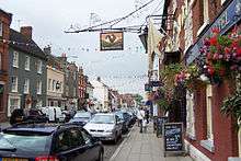
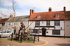 Market Place, Stony Stratford | |
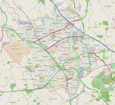 Stony Stratford Mapping © OpenStreetMap 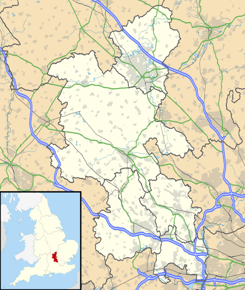 Stony Stratford Location within Buckinghamshire | |
| Population | 7,736 (2011 Census)[1] |
| OS grid reference | SP787404 |
| Civil parish |
|
| Unitary authority |
|
| Ceremonial county | |
| Region | |
| Country | England |
| Sovereign state | United Kingdom |
| Post town | MILTON KEYNES |
| Postcode district | MK11 |
| Dialling code | 01908 |
| Police | Thames Valley |
| Fire | Buckinghamshire |
| Ambulance | South Central |
| UK Parliament | |
History
Since at least Roman times, there has been a settlement here at the ford of Watling Street over the Great Ouse.[4] The town's market charter dates from 1194[5] and its status as a town from 1215.[4]
The town name 'Stratford' is Anglo-Saxon in origin, and means 'ford on a Roman road'. The Roman road in this sense is the Watling Street that runs through the middle of the town. The ford is the crossing of the River Ouse. The prefix 'Stony' refers to the stones on the bed of the ford, differentiating the town from nearby Fenny Stratford.
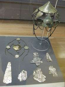
In 1789, at Windmill Field in the parish of Old Stratford near Stony Stratford, an urn was uncovered which contained three fibulae and two headdresses. Known as the Stony Stratford Hoard, it also contained around thirty fragments of silver plaques which were decorated with images of the Roman gods Mars, Apollo and Victory. There were also inscriptions to Jupiter and Vulcan leading to theories that this was a votive hoard at a Roman temple. The hoard is now kept at the British Museum.[6][7][8]
There has been a market in Stony Stratford since 1194 (by charter of King Richard I).[5] (Until the early 1900s, livestock marts were still held in the market square but in more recent times the square has become a car park, apart from a monthly farmers' market in one corner. The weekly market has moved to Timor Court, and of course no longer deals in livestock). Stony Stratford formally became a town when it received letters patent from King John in 1215.[4]
Stony Stratford was the location where, in 1290, an Eleanor cross was built in memory of the recently-deceased Queen Eleanor of Castile, as her funeral cortège had stopped overnight in the town en route to London. The cross was destroyed during the English Civil War.[4]
Wm. Shakespeare, Richard III, Act II, Scene 4
The former Rose and Crown Inn at Stony Stratford was reputedly where, in 1483, the boy-king Edward V stayed the night before he was taken to London (to become one of the Princes in the Tower) by his uncle Richard, Duke of Gloucester, who soon became King Richard III. Edward had been returning from Ludlow Castle in the Welsh Marches to London to claim his crown on the death of his father, Edward IV, when he was met in Stony Stratford by his uncle, who later deposed him.[4] The inn is now a private house but a plaque on the front wall gives a disputed account of the event, asserting that Edward was murdered in the Tower of London.
Catherine of Aragon rode from London to address her troops assembling here for the Battle of Flodden, and went on to stay at Woburn Abbey in September 1513.[9]
The town has twice become almost completely consumed by fire, the first time in 1736 and the second in 1742. The only building to escape the second fire was the tower of the chapel of ease of St Mary Magdalen.
Since at least the 15th century, Stony Stratford was an important stop on the road to Ireland via Chester, becoming quite rich on the proceeds in the 16th century.[4] In the stage coach era of the 17th and early 18th centuries, it was a major resting place and exchange point with the east/west route with coaching inns to accommodate coach travellers. Traffic on Watling Street and the consequent wear and tear to it was such as to necessitate England's first turnpike trust, from Hockliffe to Stony Stratford, in 1707.[10] In the early 19th century, over thirty mail coaches and stagecoaches a day stopped here.[11] That traffic came to an abrupt end in 1838 when the London to Birmingham Railway (now the West Coast Main Line) was opened at Wolverton – ironically, just three years after the bridge over the Ouse had been rebuilt.[4] Wolverton railway works provided an important source of employment in the town, with the Wolverton and Stony Stratford Tramway being built to serve the workers. With the arrival of the motor car, the town's position on the original A5 road made it again an important stopping point for travellers.
The 1841 census lists the population as 1,757.[12]
Before the designation of Milton Keynes in 1967, Stony was in Wolverton Urban District.
Cock and Bull Story

Due to the juxtaposition of two hotels in the centre of town, The Cock and The Bull, (both originally coaching inns) on the main London to Chester and North Wales turnpike), it is claimed locally that the common phrase a cock and bull story originated here.[13]
The modern town
Today Stony Stratford is a busy market town. Its pubs, restaurants and specialist shops attract tourists. In early June, Folk on the Green, a free festival of folk music, folk rock and eclectic taste takes over Horsefair Green.
Sport and leisure
Stony Stratford has a Non-League football team Stony Stratford Town F.C., who play at Ostler's Lane. Also, at the Ansell Trust Sports Ground, in Ostlers Lane, are also the Tennis, Bowling, Crocquet and Cricket Clubs.
In film
Scenes from the 1987 cult film Withnail and I were filmed in Stony Stratford. Cox and Robinsons chemist is the 'Penrith tea rooms' where Withnail demands "the finest wines known to humanity." The Crown pub became the 'King Henry pub' in the film. Both premises are on Market Square.
Historic parish
From about 1648, Stony Stratford was divided between the ecclesiastic parishes of Calverton and Wolverton, and covered by two chapelries, St Giles, attached to Calverton, and St Mary Magdalen, attached to Wolverton. St Mary Magdalen dates from about 1450, though only the tower remains from the 1742 fire.[4] St Giles dates from the 15th century [as a chantry chapel], but all but the tower was rebuilt in 1776 to accommodate the parishioners of St Mary Magdalen.[4] A single civil parish was established 'early' and from 1767 a single ecclesiastical parish covered the two. In modern times, the ecclesiastical parish of Stony Stratford was merged with another parish, Stony Stratford St Mary the Virgin (prior to 1953 known as Wolverton St Mary), in 1968, to create the parish of Stony Stratford St Mary and St Giles.
Around this time, the civil parish was also divided, into East (St Mary Magdelene) and West (St Giles) sides.[14] Both the civil parishes became part of Wolverton Urban District in 1919. These urban parishes were wound up in 1927 and both added to the parish of Wolverton.[15]
Modern parish
The civil parish consists of the land north H3 Monks Way to the south, the city boundary to the west, the Great Ouse to the north and the A5 road to the east. The V4 Watling Street becomes Queen Eleanor Street here as it follows the original Stony Stratford bypass. Its districts are
- Stony Stratford itself (defined H1 Ridgeway to the south, the city boundary to the west, the river to the north and the V4 Queen Eleanor Street to the east)
- Galley Hill (H1 to the south, V4 to the west and the A5 to the north-east).
- Fullers Slade (H2 to the south, H1 to the north, V4 Watling Street to the west and the A5 to the east).
The modern civil parish was established in 2001.
Buildings of historic interest
- 'Queen Anne House' also known as the 'Shell House', at 48 High Street, was once the Dower House for nearby Wolverton Manor (demolished in 1728).
- St Mary & St Giles Church (Church of England parish church)
See also
- Wolverton and Stony Stratford Tramway
- The Stony Stratford Hoard (actually found in Old Stratford parish).
References
- UK Census (2011). "Local Area Report – Stony Stratford (parish) (E04012192)". Nomis. Office for National Statistics. Retrieved 1 October 2019.
- Stony Stratford Town Council website
- Parishes in Milton Keynes Archived 8 June 2009 at the Wayback Machine – Milton Keynes Council.
- "Parishes : Stony Stratford". A History of the County of Buckingham: Volume 4. Victoria History of the Counties of England. 1927. p. 476–482. Retrieved 17 February 2019.
- R. H. Britnell, 'The Origins of Stony Stratford', Records of Buckinghamshire, XX (1977), pp. 451–3
- "Monument no. 343084". Pastscape. English Heritage. Retrieved 7 August 2010.
- British Museum Collection
- British Museum Collection
- Thomas Deloney, The Pleasant Historie of Jack of Newbery, London (1626), chapter 2: Letters & Papers Henry VIII, vol. 1 (1920) no. 2278: Calendar State Papers Venice, vol.2, no. 340: Hall, Edward, Chronicle, (1809), 564: Ellis, Henry, ed., Original Letters Illustrative of English History, 1st Series, vol.1, Richard Bentley, London (1825), 82–84, 88–89.
- "House of Lords Journal". British History Online. University of London. Retrieved 3 June 2008.
- History of Stony Stratford at MK Heritage
- The National Cyclopaedia od Useful Knowledge, Vol.III, London (1847) Charles Knight, p.899
- Quinion, Michael. "Cock and bull story". worldwidewords.org. Retrieved 26 November 2010.
- Youngs. Guide to Local Administrative Units of England: Volume 1
- Stony Stratford East – Vision of Britain
External links
| Wikivoyage has a travel guide for Stony Stratford. |
- A tour of Stony Stratford, comparing early and modern photographs, at the Milton Keynes Heritage Association web site.
- Panoramic images and large selection of photographs of the town and its locality.
- More panoramic images and continually updated photographs of the town and its locality.
- Stony Stratford Methodist Church
- 'Parishes : Stony Stratford', A History of the County of Buckingham: Volume 4 (1927), pp. 476–482.
- Aerial photographs & video of Stony Stratford and the surrounding area.
- Aerial panoramas of the landscape surrounding Stony Stratford.
- Stony Stratford redevelopment, part of Milton Keynes - A Village Life on BFI Player.
| Unitary authorities | |
|---|---|
| Major settlements | |
| Rivers | |
| Topics | |
| Authority control |
|
|---|