Whitethorn, California
Whitethorn (formerly Thorn) is an unincorporated community in Humboldt County, California.[1] It is located 9.5 miles (15 km) southwest of Garberville,[2] at an elevation of 1024 feet (312 m), population 817.[1] Whitethorn shares a ZIP code with Shelter Cove, California. It is located along California's Lost Coast. The ZIP Code is 95589.[3]
Whitethorn, California | |
|---|---|
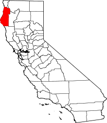 Location in the state of California | |
 Whitethorn, California Location in the United States | |
| Coordinates: 40°01′26″N 123°56′35″W | |
| Country | United States |
| State | California |
| County | Humboldt County |
| Elevation | 1,024 ft (312 m) |
Overview
The Thorn post office opened in 1888, closed in 1923, reopened in 1951, and changed its name to Whitethorn in 1961.[2] The Whitethorn post office is located near Thorn Junction on the road between Shelter Cove and Whitethorn. Some remote areas in northern Mendocino County are also served by this post office and thus have Whitethorn addresses.
Whitethorn Elementary School (grades K-7) is located in Whitethorn and is part of the Southern Humboldt Unified School District. Students from the Whitethorn area attend South Fork High School in Miranda.
Whale Gulch Elementary (grades K-8) and Whale Gulch High School are about 3 miles (5 km) southeast from Whitethorn. They have Whitethorn addresses, but are located in Mendocino County and are part of the Leggett Valley Unified School District.
About 1.5 miles (2.5 km) south of central Whitethorn is Redwoods Monastery, a community of Cistercian nuns.
The ZIP Code is 95589. The community is inside area code 707.
Climate
Whitethorn has a warm-summer Mediterranean climate (Köppen climate classification Csb) that is characterized by warm (but not hot) dry summers, and mild to chilly rainy and/or snowy winters. In Whitethorn's case, the climate is moderated by the proximity to the Pacific Ocean with small temperature variations on average throughout the year, which results in comfortable year-round temperatures.
| Climate data for Whitethorn, California | |||||||||||||
|---|---|---|---|---|---|---|---|---|---|---|---|---|---|
| Month | Jan | Feb | Mar | Apr | May | Jun | Jul | Aug | Sep | Oct | Nov | Dec | Year |
| Record high °F (°C) | 78 (26) |
80 (27) |
76 (24) |
80 (27) |
82 (28) |
85 (29) |
76 (24) |
82 (28) |
86 (30) |
84 (29) |
78 (26) |
77 (25) |
86 (30) |
| Average high °F (°C) | 54 (12) |
55 (13) |
55 (13) |
56 (13) |
58 (14) |
60 (16) |
61 (16) |
62 (17) |
62 (17) |
61 (16) |
58 (14) |
55 (13) |
58 (15) |
| Daily mean °F (°C) | 48 (9) |
49 (9) |
49 (9) |
50 (10) |
53 (12) |
56 (13) |
57 (14) |
58 (14) |
57 (14) |
55 (13) |
52 (11) |
49 (9) |
53 (11) |
| Average low °F (°C) | 41 (5) |
43 (6) |
43 (6) |
45 (7) |
48 (9) |
51 (11) |
52 (11) |
53 (12) |
51 (11) |
49 (9) |
45 (7) |
42 (6) |
47 (8) |
| Record low °F (°C) | 26 (−3) |
27 (−3) |
30 (−1) |
34 (1) |
36 (2) |
41 (5) |
46 (8) |
46 (8) |
41 (5) |
32 (0) |
30 (−1) |
21 (−6) |
21 (−6) |
| Average precipitation inches (mm) | 6.20 (157) |
5.00 (127) |
5.20 (132) |
2.80 (71) |
1.80 (46) |
0.60 (15) |
0.20 (5.1) |
0.30 (7.6) |
0.80 (20) |
2.90 (74) |
5.80 (147) |
6.30 (160) |
37.9 (961.7) |
| Source: http://www.myforecast.com/bin/climate.m?city=520760&metric=false | |||||||||||||
Politics
In the state legislature, Whitethorn is in the 2nd Senate District, represented by Democrat Mike McGuire,[4] and the 2nd Assembly District, represented by Democrat Jim Wood.[5]
Federally, Whitethorn is in California's 2nd congressional district, represented by Democrat Jared Huffman.[6]
See also
References
- U.S. Geological Survey Geographic Names Information System: Whitethorn, California
- Durham, David L. (1998). California's Geographic Names: A Gazetteer of Historic and Modern Names of the State. Clovis, Calif.: Word Dancer Press. p. 167. ISBN 1-884995-14-4.
- USPS ZIP Code lookup tool
- "Senators". State of California. Retrieved April 7, 2013.
- "Members Assembly". State of California. Retrieved April 7, 2013.
- "California's 2nd Congressional District - Representatives & District Map". Civic Impulse, LLC. Retrieved March 1, 2013.