Petrolia, California
Petrolia is an unincorporated community in Humboldt County, California,[1] 10 miles (16 km) southeast of Cape Mendocino,[3] at an elevation of 121 feet (37 m) above sea level,[1] within ZIP Code 95558,[4] and area code 707. Petrolia was the site of the first oil well drilled in California.[2]
Petrolia | |
|---|---|
 | |
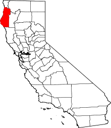
 Petrolia Location in California  Petrolia Petrolia (the United States) | |
| Coordinates: 40°19′31″N 124°17′13″W | |
| Country | United States |
| State | California |
| County | Humboldt County |
| Elevation | 121 ft (37 m) |
| Official name | California's First Drilled Oil Wells[2] |
| Reference no. | 543 |
Description
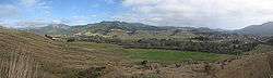
Petrolia has an estimated population of 300-500 people within a 15-mile radius. It is located in the Mattole Valley, part of the Lost Coast region, one of the largest wilderness areas and the longest stretch of undeveloped coastline in the continental United States.[5] Petrolia's isolation is due to its position on the rocky, treacherous coastline adjacent to the King Range mountains that isolate this area from mainland California and continue to leave the area almost completely undeveloped.
A travel magazine has called this area "too lovely to be believed, perhaps too beautiful to last."[6][7] It has been recognized as the top "still wild" place in California.[8] The area is the only significant stretch of California without a shoreline highway, and so far has "thus escaped tourism's aggressive paws."[9]
The 35 miles (56 km) of steep roadways beneath the King Range Mountains include towering Douglas-firs, a few coastal redwoods around the upper reaches of the Mattole River, rocky shorelines, and black sand beaches, as well as a menagerie of fauna, including black bears, black-tailed deer, river otter, California quail, bobcat and porcupine, reptiles such as rattlesnakes, western fence lizards and alligator lizards, various amphibians and bald eagles.[9]
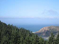
Petrolia has been described as "a river valley town with Norman Rockwell flavor."[9][10] Petrolia is 5 miles (8.0 km) from the Pacific Ocean at the north end of the 25-mile (40 km) section of beach protected by the King Range National Conservation Area and Sinkyone Wilderness State Park; the Punta Gorda Light location is about 3 miles down the coast from Mattole Beach parking. The Mattole River is home to a variety of California wildlife, including river otters, steelhead trout, more than 250 bird species, and a threatened salmon that was the subject of a book about the community's attempts over two decades to preserve the Mattole salmon.[11] It is one of the few remaining areas with virgin old-growth stands of Douglas-fir.
Geography and climate
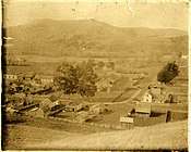
Petrolia is located near the Mendocino Triple Junction, where three fault lines meet, and experiences frequent earthquake activity. The last large earthquake to affect the area was a magnitude 7.1 earthquake in 1992, which resulted in a fire that destroyed the Petrolia General Store.[12][13] The store was rebuilt but lacks the charm of the 100-year-old landmark that it replaced. Two of the remaining landmarks in Petrolia are a small wooden church dating from 1912--St. Patrick's Catholic Church--and the Petrolia Pioneer Cemetery, which has the graves of original residents of Petrolia dating from November 1857.[14]
On the evening of March 9, 2014, a magnitude 6.9 earthquake struck approximately 50 miles to the west. It was widely felt, yet caused little to no damage, nor did it generate a tsunami. The lack of any significant damage or land deformation was attributed to the shallow strike-slip fault movement in deep (3000m) water.[15] In 2010 two other large quakes had hit the area, a 6.5 on January 9 and a 5.9 on February 3; neither caused any deaths, but the January quake was reported to have caused damage throughout the area.[16]
The weather in Petrolia is temperate. The town is located in a banana belt that is sheltered from the fog that reaches Eureka and some of the northern towns, such as Arcata and McKinleyville. As a result, the summers are dry and sunny, typically around 70 °F (21 °C) with temperatures occasionally reaching as high as 90 °F (32 °C). Winters are rainy from November through April, with temperatures typically around 50 °F (10 °C) and occasionally falling to the high 30's or low 40s (F) at night.[17] Honeydew, which is located only 14 miles (23 km) south of Petrolia, has a less temperate climate and its summers and winters are more extreme, with one of the highest amounts of winter rainfall in the contiguous 48 states.[18]
There are only two roads that lead into Petrolia, one from the north from Ferndale, California, and one from the south from Honeydew, California, leading through scenic redwood forests that were the site for the filming of Jurassic Park and After Earth. Both roads are winding, steep, and sometimes unpaved, passing large tracts of scenic overlooks and wilderness areas. They are popular routes for visitors, especially mountain bikers and motorcyclists, and have been described as leading to "an almost comically steep drop to the sea".[19] The road from Petrolia to Ferndale follows the ocean and has unbroken vistas of rocky ocean coastline and beach.[19] Petrolia is surrounded by large tracts of original homestead ranches and farms.
The Mattole area, particularly the Lost Coast beaches, which feature tide pools, pristine beaches and relatively deserted hiking trails, is popular with visitors. At certain times of year, migrating gray whales can be seen from shore, as well as colonies of harbor seals and sea lions. Local residents use the Mattole River for swimming, rafting, canoeing, kayaking and catch and release fly fishing. The South Cape Mendocino State Marine Reserve and Sugarloaf Rock are immediately offshore and are closed to public access.[20][21]
History
The area was originally settled by the Mattole, a Pacific Coast Athapaskan people,[22] who arrived at the Pacific Coast late in the first millennium from what is now Canada.
The Mattole Indians were slaughtered by the Western settlers, mainly oil prospectors and ranching homesteaders.[23][24] The last remaining descendants of the Mattole live today in Bear River on the Rohnerville Rancheria, but there are no remaining native speakers of the Mattole language.[23] There are estimated to be more than 80 archeological sites of significance in the Lost Coast area.

Although it's often stated that Petrolia was first named "New Jerusalem," that area is 4-5 miles upstream; however, many people like the holy connotations of being called something like paradise. Petrolia was the site of the first oil well drilled in California.[2] The oil lay in small, fractured underground pools and ultimately, attempts to extract it dried up; the site is now registered as California Historical Landmark #543.[2]
The Mattole post office opened in 1863, and changed its name to Petrolia in 1865.[3] A 1903 fire wiped out many buildings around the town square.[25]
On March 9, 2020, a magnitude 5.8 earthquake occurred 86 km West of the city. The official time of the earthquake was 02:59:06 (UTC). 2660 people reported effects from the earthquake. [26][27]
Facilities
Petrolia has a small general store with groceries, one gas pump and rental movies. It has a post office and a volunteer fire department. The original bell cast in 1871 for the Mattole School is still located at the school.
There are two community centers, the Mattole Valley Community Center (originally the school house from 1907 and moved across the street) that hosts community cabaret and gatherings, and the Mattole Grange, an indoor and outdoor gathering area approximately five miles south of Petrolia that hosts a monthly pancake breakfast and farmers' market. There are community gardens, various community clubs, and a medical clinic.
Local businesses include a bed and breakfast, a gourmet coffee company that imports and roasts coffee in a converted barn on a hillside overlooking the ocean, an organic vineyard and winery, an organic pick-it-yourself blueberry farm and an abundance of marijuana growers. Marijuana has long since replaced the ranching and logging that sustained the original residents for generations.
A few miles outside town at the former Walker ranch is a 400 feet (120 m) by 20 feet (6.1 m) underground steel and concrete vault, built by the Scientology organization called Church of Spiritual Technology to hold "the wisdom of the ages."[28][29] The Church owns over 3,600 acres (1,500 ha; 5.6 sq mi) of land and the facility also includes a large caretaker's house and a guard house.[28][30] The vault is one of several across the U.S. and is similar to Trementina Base.[28] Prior to construction of this vault, on June 12, 1986, one of the oldest houses in the Petrolia area was deliberately burned by the Church of Spiritual Technology to clear the way for their construction,[31] and symbols were cut in the ground above the vault to mark its location.[32]
Inhabitants
A number of writers and artists have made their home in Petrolia, including Alexander Cockburn, a left-wing journalist and founder of CounterPunch, Dale Maharidge, a journalist and winner of the Pulitzer Prize, Freeman House, an environmental author, Peter Hannaford, an author and political public relations specialist, Jim Danisch, a potter and sculptor, Jenny Scheinman, renowned violinist, and Matteo Giglioli, Italian-American political scientist and author.
Petrolia has a large population of environmental activists and hosts two environmental organizations, the Mattole Salmon Group [33] and the Mattole Restoration Council,[34] both dedicated to preserving the local wildlife and environment.
Culture
The Mattole Valley Historical Society holds occasional public meetings in Petrolia and conducts community walking tours, slideshows and talks about the history of the area and its founders.[35]
Community events including all-ages sporting events, town-wide talent shows, pancake breakfasts, and community meet-ups. In July of each year, the area hosts a music festival called "Roll on the Mattole",[36] at the Mattole Grange, sponsored by the Honeydew Volunteer Fire Company. Twice a year, barbecues at the Mattole Grange attract families from all over the area;[37] the July 4th and Labor Day weekend annual barbecues features an enormous barbecue pit of local beef and baked beans cooked in a vintage pot so large that they must be stirred with a canoe paddle.[37] There are horse races in September, cycling tours in May–September,[38] including a cycling/hiking tour of the Redwoods [39] and the Tour of the Unknown Coast, a one-hundred mile bike race beginning and ending in Ferndale.[40] A race called the "Rye and Tide" combines bicycling and running from downtown Petrolia along Lighthouse Road 7 miles (11 km) to the ocean.[41] Besides the general store, the Sunday farmers' market and cafe at the Community Center, and a new food cart downtown, the closest amenities are located in Ferndale, approximately 33 miles (53 km), a trip of over an hour by car.
Because of its isolation, the Mattole Valley has cultivated a reputation for independence and self-sustenance, including a network of local resources-- the maintenance of its own emergency help line (augmenting 9-1-1).
In the state legislature, Petrolia is in the 2nd Senate District, represented by Democrat Mike McGuire,[42] and the 2nd Assembly District, represented by Democrat Jim Wood.[43]
Federally, Petrolia is in California's 2nd congressional district, represented by Democrat Jared Huffman.[44]
See also
References
- U.S. Geological Survey Geographic Names Information System: Petrolia, California
- "California's First Drilled Oil Wells". Office of Historic Preservation, California State Parks. Retrieved 2012-10-07.
- Durham, David L. (1998). California's Geographic Names: A Gazetteer of Historic and Modern Names of the State. Clovis, Calif.: Word Dancer Press. p. 121. ISBN 1-884995-14-4.
- "USPS.com ZIP Code Lookup". United States Postal Service. Retrieved November 27, 2013.
- Watanabe McFerrin, Linda (July 18, 2004). "Finding the Lost Coast". SFGate. Archived from the original on May 24, 2011. Retrieved November 27, 2013.
...comprising more than 67,500 acres (273 km2) of untouched wilderness...
- "After 100 Years...There's Still An Unknown Coast". Sunset Magazine. 118:5: 24–26, 28, 30–31. May 1957.
- "The Mattole Road...Ferndale, Petrolia, And Honeydew". Sunset Magazine. 144:5: 48–50. May 1970.
- The Editors of California Wild (Winter 1998). "Still Wild". California Wild. California Academy of Sciences. 51:1. Archived from the original on 23 May 2006.
- Baer, Adam. "California's Lost Coast". Men's Journal. Retrieved 15 January 2013.
- Arroyo, Natalie (7 July 2011). "Last Call for Coho". North Coast Journal. Retrieved 15 January 2013.
- "A review of 'Totem Salmon' by Freeman House". Grist. 15 May 1999. Retrieved 27 November 2013.
- "The Cape Mendocino Earthquakes of April 25-26, 1992 (20 Images)". John Martin Engineering. Retrieved 15 January 2013.
- National Geophysical Data Center. "April 25, 1992 Cape Mendocino USA earthquake". National Oceanic and Atmospheric Administration. Retrieved 15 January 2013. Note photos of cracks in the Mattole Road as well as damage to buildings and landslides.
- "Petrolia Pioneer Cemetery: Wright, Marshall". Digging Up Humboldt. 7 March 2011. Retrieved 15 January 2013.
- "Location of Sunday's 6.9 quake reduced impact to North Coast". Times-Standard. 10 March 2014. Retrieved 1 June 2014.
- "Strong Earthquake Reported Off Northern California Coast". Fox News. 4 February 2010. Retrieved 15 January 2013.
- "Past Monthly Weather Data for Petrolia, CA [California] ("Upper Mattole") : JANUARY, 1900 - 1986". Weather Warehouse. Archived from the original on 2 December 2013. Retrieved 15 January 2013.
- "Past Monthly Weather Data for Honeydew, CA [California] ("Honeydew 1 Sw") : JANUARY, 1959 - 2013". Weather Warehouse. Archived from the original on 2 December 2013. Retrieved 15 January 2013.
- Dixon, Chris (29 April 2005). "A Coast Less Traveled". New York Times. Archived from the original on 3 December 2013. Retrieved 15 January 2013.
- California Department of Fish and Wildlife , California Protected Marine Areas, 14 March 2013
- California Department of Fish and Wildlife, Sugarloaf Island Special Closure, 2015
- "Mattole Language and the Mattole Indian Tribe (Bear River, Bettol)". Native Languages of the Americas. Retrieved 15 January 2013.
- Cooskey, Laura. "So...what happened to the Natives here?" (PDF). Mattole Valley Historical Society. Archived from the original (PDF) on 29 March 2013. Retrieved 15 January 2013.
- Bussell, Gordon. "The Mattole" (PDF). Mattole Valley Historical Society. Archived from the original (PDF) on 5 September 2012. Retrieved 15 January 2013.
- McCooskey, Laura. "Album found in Dumpster yields treasure". West of the Redwoods Historical Views from the Mattole Valley of Northern California. Mattole Historical Society. Retrieved 14 May 2020.
- "M 5.8 - 86km W of Petrolia, CA". Earthquake.gov. National Earthquake Center. Retrieved 9 March 2020.
- Baron, Ethan. "Magnitude 5.8 earthquake shakes Northern California coast". Mercury News. Mercury News. Retrieved 9 March 2020.
- Cempa, Joe (June 1991). "Petrolia's New Neighbors -- L. Ron Hubbard's followers, the Church of Spiritual Technology". North Coast Journal. Retrieved 15 January 2013.
The assessed valuation of the 23 parcels owned by the church is $1.19 million, with improvements valued at $510,533., according to county records. Records also showed that the church's tax bill for 1990-01 is $18,488.
- Durham, Jack (1 May 1991). "Scientology church builds Humboldt vault". Lumberjack. Arcata, California: Humboldt State University. 68 (27). Retrieved 15 January 2013.
- Smith, Chris (9 February 1992). "Millennial mission: Underground vault holds Scientology teachings". Empire News. Santa Rosa, California. Retrieved 15 January 2013.
- "It's Called The Church Of Spiritual Technology". Ferndale Enterprise. Ferndale, Humboldt County, California. 14 December 1989. Retrieved 15 January 2013.
- 40.368213°N 124.333284°W
- Mattole Salmon Group
- Mattole Restoration Council
- Mattole Valley Historical Society Archived 2007-09-15 at the Wayback Machine webpage
- Roll on the Mattole Archived 2013-02-16 at Archive.today, North Coast Journal, accessdate 15 January 2013]
- Mattole Grange, website
- cycling tours
- cycling/hiking tour of the Redwoods
- Tour of the Unknown Coast - America's toughest century, accessdate 15 January 2013
- Petrolia California, Back to Basics Archived 2013-02-17 at Archive.today, accessdate 15 January 2013
- "Senators". State of California. Retrieved April 7, 2013.
- "Members Assembly". State of California. Retrieved April 7, 2013.
- "California's 2nd Congressional District - Representatives & District Map". Civic Impulse, LLC. Retrieved March 1, 2013.
External links
- Lost Coast Wilderness Area
- Lost Coast Trail
- Humboldt Music Calendar
- Mattole Wildlands Defense Blog
- McHugh, Paul, Way off the beaton track / Lost Coast road offers rugged fun, SF Gate, 27 June 2002, accessdate 15 January 2013.
- Barnes, Amy, John McAbery carves out a life on the Lost Coast, SF Gate, 8 April 2012, accessdate 15 January 2013.
- https://www.topic.com/the-silver-currency-of-cannabis-country