Myrtletown, California
Myrtletown is a census-designated place (CDP) in Humboldt County, California, United States. Myrtletown lies at an elevation of 112 feet (34 m).[3] Myrtletown is a part of the Eureka, California metropolitan area. The population was 4,675 at the 2010 census, up from 4,459 at the 2000 census.
Myrtletown | |
|---|---|
Census designated place | |
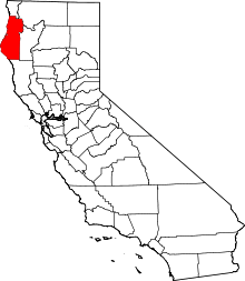
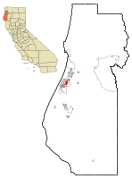 Location in Humboldt County and the state of California | |
| Coordinates: 40°47′19″N 124°07′49″W | |
| Country | |
| State | |
| County | Humboldt |
| Area | |
| • Total | 2.181 sq mi (5.650 km2) |
| • Land | 2.099 sq mi (5.437 km2) |
| • Water | 0.082 sq mi (0.213 km2) 3.8% |
| Elevation | 112 ft (34 m) |
| Population | |
| • Total | 4,675 |
| • Density | 2,100/sq mi (830/km2) |
| Time zone | UTC-8 (Pacific) |
| • Summer (DST) | UTC-7 (PDT) |
| ZIP code | 95501 |
| Area code | 707 |
| FIPS code | 06-50188 |
| GNIS feature ID | 1867044 |
| [2] | |
Geography
According to the United States Census Bureau, the CDP has a total area of 2.2 square miles (5.7 km2), of which, 2.1 square miles (5.4 km2) of it is land and 0.04 square miles (0.10 km2) of it (1.39%) is water.
Demographics
2010
At the 2010 census Myrtletown had a population of 4,675. The population density was 2,143.3 people per square mile (827.5/km²). The racial makeup of Myrtletown was 3,969 (84.9%) White, 53 (1.1%) African American, 142 (3.0%) Native American, 155 (3.3%) Asian, 19 (0.4%) Pacific Islander, 126 (2.7%) from other races, and 211 (4.5%) from two or more races. Hispanic or Latino of any race were 387 people (8.3%).[4]
The census reported that 4,475 people (95.7% of the population) lived in households, 106 (2.3%) lived in non-institutionalized group quarters, and 94 (2.0%) were institutionalized.
There were 1,992 households, 496 (24.9%) had children under the age of 18 living in them, 777 (39.0%) were opposite-sex married couples living together, 192 (9.6%) had a female householder with no husband present, 109 (5.5%) had a male householder with no wife present. There were 158 (7.9%) unmarried opposite-sex partnerships, and 24 (1.2%) same-sex married couples or partnerships. 713 households (35.8%) were one person and 319 (16.0%) had someone living alone who was 65 or older. The average household size was 2.25. There were 1,078 families (54.1% of households); the average family size was 2.89.
The age distribution was 914 people (19.6%) under the age of 18, 414 people (8.9%) aged 18 to 24, 1,169 people (25.0%) aged 25 to 44, 1,205 people (25.8%) aged 45 to 64, and 973 people (20.8%) who were 65 or older. The median age was 41.3 years. For every 100 females, there were 89.1 males. For every 100 females age 18 and over, there were 86.7 males.
There were 2,132 housing units at an average density of 977.4 per square mile (377.4/km²),of which 1,992 were occupied, 1,032 (51.8%) by the owners and 960 (48.2%) by renters. The homeowner vacancy rate was 0.9%; the rental vacancy rate was 3.5%. 2,413 people (51.6% of the population) lived in owner-occupied housing units and 2,062 people (44.1%) lived in rental housing units.
2000
At the 2000 census there were 4,459 people, 1,738 households, and 1,119 families in the CDP. The population density was 2,097.2 people per square mile (808.3/km²). There were 1,827 housing units at an average density of 859.3 per square mile (331.2/km²). The racial makeup of the CDP was 89.35% White, 0.78% Black or African American, 2.85% Native American, 1.39% Asian, 0.07% Pacific Islander, 1.12% from other races, and 4.44% from two or more races. 4.58% of the population were Hispanic or Latino of any race.[5] Of the 1,738 households 31.1% had children under the age of 18 living with them, 47.8% were married couples living together, 11.5% had a female householder with no husband present, and 35.6% were non-families. 27.6% of households were one person and 11.0% were one person aged 65 or older. The average household size was 2.42 and the average family size was 2.92.
The age distribution was 23.5% under the age of 18, 8.0% from 18 to 24, 27.1% from 25 to 44, 22.7% from 45 to 64, and 18.6% 65 or older. The median age was 39 years. For every 100 females, there were 86.4 males. For every 100 females age 18 and over, there were 82.5 males.
The median household income was $37,417 and the median family income was $43,250. Males had a median income of $32,500 versus $22,161 for females. The per capita income for the CDP was $19,057. About 14.4% of families and 13.3% of the population were below the poverty line, including 25.2% of those under age 18 and 6.4% of those age 65 or over.
Architecture
Myrtletown is known for having a high concentration of homes built by the Pierson Building Company, a local builder of mass-produced homes, which were primarily produced in the 1950s and 1960s. These homes form a unique Pierson style characterized by low-pitched roofs, floor-to-ceiling picture windows, and open, central floor plans. The periphery areas of Myrtletown primarily contain houses built in the latter half of the 20th century. However, several houses exist from the 1930s and 40s, when the area was grassy and open.
Politics
In the state legislature, Myrtletown is in the 2nd Senate District, represented by Democrat Mike McGuire,[6] and the 2nd Assembly District, represented by Democrat Jim Wood.[7]
Federally, Myrtletown is in California's 2nd congressional district, represented by Democrat Jared Huffman.[8]
See also
References
- "2010 Census U.S. Gazetteer Files – Places – California". United States Census Bureau.
- "Myrtletown". Geographic Names Information System. United States Geological Survey. Retrieved March 24, 2015.
- U.S. Geological Survey Geographic Names Information System: Myrtletown, California
- "2010 Census Interactive Population Search: CA - Myrtletown CDP". U.S. Census Bureau. Archived from the original on July 15, 2014. Retrieved July 12, 2014.
- "U.S. Census website". United States Census Bureau. Retrieved 2008-01-31.
- "Senators". State of California. Retrieved March 10, 2013.
- "Members Assembly". State of California. Retrieved March 2, 2013.
- "California's 2nd Congressional District - Representatives & District Map". Civic Impulse, LLC. Retrieved March 1, 2013.