West Lothian
West Lothian (Scots: Wast Lowden; Scottish Gaelic: Lodainn an Iar) is one of the 32 council areas of Scotland, and one of its historic counties. The county, which was also known as Linlithgowshire [1], was bounded geographically by the Avon to the west and the Almond to the east. The modern council area occupies a larger area, with areas in the west transferred to Falkirk and areas in the east transferred to Edinburgh following local government reforms in the late 20th century. It did however gain areas from Midlothian.
West Lothian | |
|---|---|
 | |
 Coat of arms | |
| Coordinates: 55°55′N 3°30′W | |
| Sovereign state | United Kingdom |
| Country | Scotland |
| Lieutenancy area | West Lothian |
| Admin HQ | Livingston |
| Government | |
| • Body | West Lothian Council |
| • Control | Labour minority (council NOC) |
| • MPs | |
| • MSPs | |
| Area | |
| • Total | 165.1 sq mi (427.7 km2) |
| Area rank | Ranked 20th |
| Population (mid-2019 est.) | |
| • Total | 182,140 |
| • Rank | Ranked 9th |
| • Density | 1,100/sq mi (430/km2) |
| ONS code | S12000040 |
| ISO 3166 code | GB-WLN |
| Website | www |
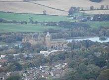
West Lothian lies on the southern shore of the Firth of Forth and is predominantly rural, though there were extensive coal, iron, and shale oil mining operations in the 19th and 20th centuries, which created distinctive red spoil heaps (locally known as "bings") throughout the council area. The old county town was the royal burgh of Linlithgow, but the largest town (and the second largest town in Lothian after Edinburgh) is now Livingston.
Geography
The modern council area borders, in a clockwise direction, the council areas of Edinburgh, the Scottish Borders, North and South Lanarkshire, and Falkirk. The traditional county bordered Midlothian to the south-east, Lanarkshire to the south-west and Stirlingshire to the west. Its border with Midlothian was formed by the Briech Water, from its source until it reached the Almond, and it then followed the Almond to the Firth of Forth (except by Livingston, where Midlothian intruded about a mile past the Almond to include the hamlets of Howden, Craigshill, and Pumpherston). The western border was formed first by the Drumtassie Burn and then by the Avon. It had an area of 120 sq. miles (310 km2), making it the third smallest of Scotland's 33 counties and smaller than the modern council area.
Geologically, most of the area is underlaid by Carboniferous sedimentary rocks running in strips from north to south. The eastern and southern rocks are the oldest and least useful. Further west is a large field of shale oil, then sedimentary and basalt rocks supplying silica sand, and then coal.
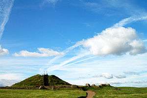
The area rises from lowlands in the north to the Pentland Hills in the southeast, while the southwest is moorland. Cairnpapple Hill is the highest peak at 312 m (1,024 ft), making it the lowest county top in Scotland. Two thirds of the land is agricultural, while a tenth is urban. Significant watercourses include the Almond and the Union Canal, while the main bodies of water are Linlithgow Loch, Dundas Loch, Humbie Reservoir, Lochcote Reservoir, Beecraigs Loch and Bangour Reservoir. The small island of Inchgarvie near the Forth Bridge lies within the historic borders of the county.
Boundaries
The creation of the modern council area drastically altered West Lothian's boundaries. Significant towns not included in the modern county are the coastal burghs of Bo'ness and Queensferry and the town of Kirkliston. Large parts of the southern urban area of Livingston, which were historically within Midlothian, were however transferred to West Lothian.
History
West Lothian was extensively settled in prehistoric times, and several ancient burial sites have been uncovered, such as at Cairnpapple Hill. There are remains of hillforts on Cockleroy, Peace Knowe, Bowden, Cairnpapple, and Binns Hills. The area was anciently inhabited by Britons of the tribe known as the Votadini or Gododdin. By 83 AD, southern Scotland had been conquered by Romans, who built a road from their fort at Cramond to the eastern end of the Antonine Wall, as well as forts in West Lothian (of which Castle Greg is a known example). The Romans withdrew roughly two centuries later, and the area was left to the Britons until the arrival of Anglo-Saxons in the fifth and sixth centuries, who brought Lothian under the rule of the Kingdom of Northumbria. In later centuries the region was regularly overrun by Gaelic-speaking Scots, and it became permanently part of the Kingdom of Scotland in the 11th century.
Scotland was split into sheriffdoms, what would later become counties, in the reign of David I. The first known reference to a sheriff of Linlithgow occurs in a charter dating from the reign of his successor Malcolm IV. For a time West Lothian became a constabulary, but it seems to have been made a sheriffdom again during the reign of James III.

In pre-industrial times West Lothian was almost entirely agricultural. In the way of heavy industry there was a silver mine at Cairnpapple, a cotton mill at Blackburn, paper mills at Linlithgow, and shallow coal mines around Bathgate and Whitburn. The county was radically changed by the Industrial Revolution,(from about 1760 to sometime between 1820 and 1840) with the opening of deep-pit iron, coal, and shale oil mines, as well as foundries and brickworks. Many of the houses built for the expanding population were shoddy, necessitating the building of thousands of council houses in the latter part of the 20th century, especially at Livingston, which had historically been a minor village. The bings produced by the mining industry, 19 of which still stand in West Lothian, were at first considered blights, but now are thought of as monuments to Scotland's industrial past, and a representation of one appears on the council's coat of arms. Heavy industry declined after the Second World War, and the last shale oil mine closed in 1962.
Government and politics
County
.jpg)
The county of West Lothian or of Linlithgowshire contained six burghs: Armadale, Bathgate, Bo'ness, Linlithgow, Queensferry, and Whitburn. Areas outside the burghs were administered as districts, of which there were also six: Borrowstounness, Linlithgow, Queensferry, Torphichen & Bathgate, Uphall, and Whitburn & Livingston.
The county was also split into twelve parishes; these were not used for administrative purposes after 1929.
District
The Local Government (Scotland) Act 1973 abolished the counties, burghs, and districts, instead creating a system of regions and districts. West Lothian was made a district of Lothian region but lost the burgh of Bo'ness and the district of Bo'ness to Falkirk district of Central Region, the burgh of Queensferry and the district of Kirkliston and part of Winchburgh to Edinburgh district of Lothian Region. It gained East Calder and West Calder districts from Midlothian. The two-tier system was abolished by the Local Government etc. (Scotland) Act 1994, and the district of West Lothian was made a unitary council area.
Parliamentary representation
The West Lothian question, referring to whether Scottish, Welsh, and Northern Irish MPs should be allowed to vote on English laws, is so named because it was supposedly first raised by Tam Dalyell while he was MP for West Lothian.[2][3]
Council political composition
| Party | Councillors | |
| Scottish National Party | 13 | |
| Labour | 12 | |
| Conservative | 7 | |
| Independent | 1 |
Settlements
Settlements in both historic and modern West Lothian


- Abercorn
- Armadale
- Bathgate
- Bents
- Blackburn
- Blackridge
- Bridgend
- Broxburn
- Deans
- Dechmont
- East Whitburn
- Ecclesmachan
- Eliburn
- Fauldhouse
- Greenrigg
- Knightsridge
- Ladywell
- Linlithgow
- Livingston (part)
- Livingston Village
- Longridge
- Philpstoun
- Seafield
- Stoneyburn
- Torphichen
- Uphall
- Uphall Station
- Westrigg
- Winchburgh
Settlements historically in West Lothian but since transferred elsewhere
- Blackness (now in Falkirk)
- Bo'ness (now in Falkirk)
- Dalmeny (now in Edinburgh)
- Kirkliston (now in Edinburgh)
- Muirhouses (now in Falkirk)
- South Queensferry (now in Edinburgh)
Settlements in modern West Lothian but which were not historically part of the county
All of the following areas were historically in Midlothian:
- Adambrae
- Addiewell
- Bellsquarry
- Breich
- Cobbinshaw
- Craigshill
- Dedridge
- East Calder
- Harburn
- Howden
- Kirknewton
- Levenseat
- Livingston (part)
- Mid Calder
- Murieston
- Polbeth
- Pumpherston
- West Calder
- Wilkieston
Places of interest
- Beecraigs Country Park
- Cairnpapple Hill
- Linlithgow Palace, birthplace of Mary, Queen of Scots
- Polkemmet Country Park
- Torphichen Preceptory
See also the pages of the West Lothian Archaeological Trust
Famous residents
- Susan Boyle, from Blackburn, a singer who achieved fame on the TV series Britain's Got Talent[4][5]
- Ian Colquhoun, from Livingston, author and actor
- Dario Franchitti, from Whitburn, four-time Indy Car series champion, and three-time winner of the Indianapolis 500
- Leon Jackson, from Whitburn, winner of The X Factor in 2007
- James the Fifth, born at Linlithgow Palace, King of Scots
- Mary, born at Linlithgow Palace, Queen of Scots
- Paul di Resta, from Uphall, DTM race driver for Mercedes-Benz, and the cousin of Dario Franchitti
- Alex Salmond, from Linlithgow, politician and former First Minister of Scotland
- David Tennant, from Bathgate, actor
- Sir Charles Wyville Thompson, from Linlithgow
- Lewis Capaldi, singer / songwriter from Whitburn, Bathgate
- Paige Turley, winner of Love Island, in 2020 (series 6), from Fauldhouse
- Peter 'Snakebite' Wright, Born in Livingston, Reigning PDC World darts champion
See also
References
- "West Lothian". Gazetteer for Scotland. Archived from the original on 13 June 2020. Retrieved 13 June 2020.
- "Scottish referendum: What is the 'English Question'?". BBC News. BBC. 19 September 2014. Retrieved 26 April 2015.
- "Now for the English question". The Economist. 27 September 2014.
- "Singing Talent of Susan Boyle Stuns Simon Cowell", Times of London Archived March 20, 2010, at the Wayback Machine
- Leigh Holmwood (14 April 2009). "Britain's got talent hits high note,'". Guardian. London. Retrieved 20 September 2010.
- Penney, John (1832). A Topographical and Historical Account of Linlithgowshire. Edinburgh: Stevenson.
- "West Lothian's Heritage". West Lothian Council.
External links
![]()
- West Lothian Council official government website
- West Lothian at Curlie
- West Lothian Archaeology Group
- West Lothian Family History Society
Local government areas of Scotland, in use 1973 to 1996 | ||
|---|---|---|
| Borders |  | |
| Central Region | ||
| Dumfries and Galloway | ||
| Fife | ||
| Grampian | ||
| Highland | ||
| Lothian | ||
| Strathclyde | ||
| Tayside | ||
| Island areas1 | ||