Banffshire
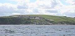
Banffshire (/ˈbænfʃər/; Scots: Coontie o Banffshire; Scottish Gaelic: Siorrachd Bhanbh) is a historic county, registration county[1] and lieutenancy area of Scotland. The county town is Banff, although the largest community is Buckie to the west. It borders the Moray Firth to the north, Morayshire and Inverness-shire to the west, and Aberdeenshire to the east and south.
Banff | |
|---|---|
 | |
| Country | Scotland |
| County town | Banff |
| Area | |
| • Total | 641 sq mi (1,660 km2) |
| Ranked 13th of 34 | |
| Chapman code | BAN |
Local government council
Between 1890 and 1975 the County of Banff, also known as Banffshire, had its own county council. In 1975 Banffshire was abolished for the purpose of local government and its territory divided between the local government districts of Moray and Banff and Buchan, which lay within the Grampian region. In 1996, the Grampian region was abolished, and the area now lies within the council areas of Moray and Aberdeenshire (note that both these polities have different boundaries to the historic counties of the same names).
Geography
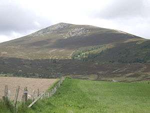
Banffshire consists of a 30-mile segment of coast along the Moray Firth from Spey Bay to Cullaykhan Bay, the immediate hinterland, plus a long, tapering 'tail' stretching inland some 55 or so miles, thus giving the county a rather odd, elongated shape. The coastal section is fairly flat, with a large numbers of bays and headlands (the most notable of these being - from west to east - Craig Head, Long Head, Cullen Bay, Logan Head, Crathie Point, Sandend Bay, Links Bay, Strathmarchin Bay, Cowhythe Bay, Boyne Bay, Whyntie Head, Knock Head, Boyndie Bay, Banff Bay, Head of Garness, More Head, Gamrie Bay, Troup Head, Downie Bay and Cullykhan Bay. Some small islands lies of the coast, such as West Muck, East Muck, Craigenroan and the Collie Rocks. The interior is generally hilly, rising to the Cairngorms in the far south, where the highest peak in the county and second highest in Scotland (Ben Macdhui) can be found on the border with Aberdeenshire. The county's largest lochs are also located in the far south, such as Loch Avon, Dubh Lochan, Lochan a' Bhainne, Lochan nan Gabhar and Loch Builg. The main rivers are the Deveron, Spey, Isla, Aven, Fiddich, Ailnach and Livet.
History
Considerable evidence of prehistoric human habitation exists particularly near the coastal area. For example, the Longman Hill cairn[2] and Cairn Lee are situated in the northern portion of Banffshire in the vicinity of the Burn of Myrehouse.[3]
Located in the area are the ruins of several medieval castles and the 12th century kirk of Gamrie.
The region remained largely Roman Catholic after the Reformation (16th century) and suffered greatly in the ensuing struggles.
During the Wars of the Three Kingdoms (17th century), Banffshire was a Royalist stronghold.
Until 1891 the county contained various exclaves which were locally situated in Aberdeenshire, the biggest being the parish and village of St. Fergus.[4]
Civil parishes

Civil parishes are still used for some statistical purposes, and separate census figures are published for them. As their areas have been largely unchanged since the 19th century this allows for comparison of population figures over an extended period of time.
From 1845 to 1930, parishes formed part of the local government system of Scotland, having parochial boards from 1845 to 1894.
- Aberlour
- Alvah
- Banff
- Bellie (probably now all in Moray)
- Boharm
- Botriphnie Drummuir
- Boyndie
- Cabrach
- Cullen
- Deskford
- Fordyce
- Forglen
- Gamrie
- Glass[5]
- Grange
- Inveraven or Inveravon
- Inverkeithny
- Keith
- Kirkmichael (possibly all in Banffshire)
- Marlach or Marnoch
- Mortlach (Mortlach distillery)
- Rathven
- Rothiemay Milltown of Rothiemay
- Rothnie
- Ontiquhill or Ordiquhill
Settlements

- Aberchirder
- Banff
- Bogmuir
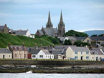
- Buckie
- Charlestown of Aberlour
- Cornhill
- Craigellachie
- Cullen
- Dufftown
- Findochty
- Fordyce
- Gardenstown
- Glenlivet
- Ianstown
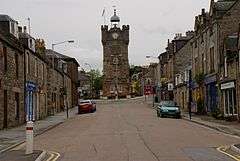
- Keith
- Kirktown of Alvah
- Kirktown of Mortlach
- Ladysbridge
- Lintmill
- Macduff
- Marypark
- Milltown of Rothiemay
- Newmill
- Portessie
- Portgordon
- Portknockie
- Portsoy
- Rathven
- Sandend
- Spey Bay
- Tomintoul
- Upper Dallachy
- Whitehills
Transport
The Aberdeen–Inverness railway line runs through the town of Keith in the north of the county.
Architecture
Principal mansions
Principal mansions in Banffshire c. 1854 The Imperial Gazetteer of Scotland (1854) Vol. I. by the Rev. John Marius Wilson[6] lists the following :
- Auchintoul
- Auchlunkart House (A. Steuart)
- Balveny Castle or Balvenie Castle
- Cairfield House (John Gordon)
- Cullen House (Earl of Seafield)
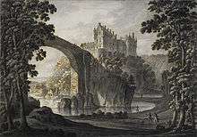
- Duff House
- Edingight House (Major A.F. Innes Taylor)
- Forglen House and Birkenbog (Sir Robert Abercrombie)
- Gordon Castle (Duke of Richmond)
- Letterfourie (Sir William Gordon)
- Mayen House (William Duff)
- Mount-coffer House (Earl of Fife)
- Park House (Colonel Thomas Gordon)
- Rothiemay
Castles in Banffshire

- Auchindune Auchindoun Castle
- Balveny or Balvenie
- Banff
- Cullen (near Cullen) [7]
- Deskford
- Edinglassie
- Findochty
- Galval or Gouldwell Castle (Boharm Civil Parish)
- Grange
- Inchdrewer, Banff Parish
- Park
- Scuth
Notable residents
- James Abercromby, (1706-1781), born in Glassaugh, British general in the French and Indian War.[8]
- Captain George Duff RN (c. 1 February 1764 – 21 October 1805) was a British naval officer during the American War of Independence, the French Revolutionary Wars and the Napoleonic Wars, who was killed by a cannonball at the Battle of Trafalgar. Born in Banff
- James Ferguson, FRS (1710-1776), born Rothiemay, astronomer and instrument maker.[9]
- George Gauld (surveyor)
- Saint John Ogilvie, (1579-1615), born in Keith was a Scottish Catholic martyr.
- George Stephen, 1st Baron Mount Stephen 1829-1921 Canadian railway executive who named Banff, Alberta after his birthplace; Banff National Park and Banff Springs Hotel are linked to Stephen back to Banffshire
Surnames
Most common surnames in Banffshire at the time of the United Kingdom Census of 1881:[10]
See also
References
- Registers of Scotland. Publications, leaflets, Land Register Counties Archived 7 July 2013 at the Wayback Machine.
- "Longman Hill (Long Barrow) | UK". The Modern Antiquarian.com. 24 December 1924. Retrieved 12 November 2012.
- United Kingdom Ordnance Survey Map 1:50,000 (2004)
- "St Fergus through time | Census tables with data for the Scottish Parish". Visionofbritain.org.uk. Retrieved 12 November 2012.
- The Imperial gazetteer of Scotland (1854) of Scotland (1854) by Rev. John Marius Wilson https://archive.org/stream/imperialgazettee01wils#page/791/mode/1up
- The Imperial gazetteer of Scotland (1854). Vol I. by Rev. John Marius Wilson p.130
- "History of Deskford Castle by Cullen & Deskford Church of Scotland". Retrieved 4 February 2017.
- Who Was Who in America, Historical Volume, 1607-1896. Chicago: Marquis Who's Who. 1963.
- "Library and Archive Catalog". The Royal Society. Retrieved 21 July 2010.
- "Banffshire Genealogy Resources & Parish Registers". Retrieved 4 February 2017.
External links
| Wikimedia Commons has media related to Banffshire. |
- . Encyclopædia Britannica. 3 (11th ed.). 1911.