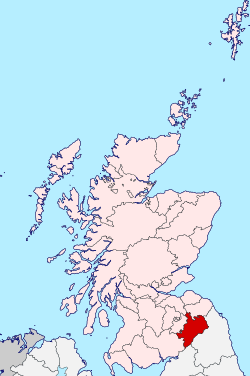
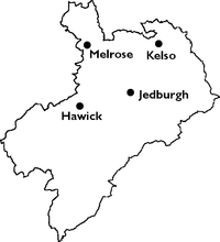
Roxburghshire
Roxburghshire or the County of Roxburgh is a historic county and registration county in the Southern Uplands of Scotland. It borders Dumfriesshire to the west, Selkirkshire and Midlothian to the north-west, and Berwickshire to the north. To the south-west it borders Cumberland and to the south-east Northumberland, both in England.
Roxburgh | |
|---|---|
 | |
| Country | Scotland |
| County town | Jedburgh |
| Area | |
| • Total | 666 sq mi (1,725 km2) |
| Ranked 12th of 34 | |
| Chapman code | ROX |
It was named after the Royal Burgh of Roxburgh, a town which declined markedly in the 15th century and is no longer in existence. Latterly, the county town of Roxburghshire was Jedburgh.
The county has much the same area as Teviotdale, the basin drained by the River Teviot and tributaries together with the adjacent stretch of the Tweed into which it flows. The term is often treated as synonymous with Roxburghshire, but may omit Liddesdale as Liddel Water drains to the west coast.[1]
History
The county appears to have originated in the 12th century with the creation of the sheriffdom of Roxburgh. The first known sheriff is Gospatric (sheriff of Roxburgh). The hereditary sheriffship of Roxburghshire was possessed by the family of Douglas until the abolition of heritable jurisdictions in the 18th century.[2]
The county was constantly fought over in the Middle Ages as part of the Anglo-Scottish Wars, before the border settled into roughly its modern form with the Treaty of York in 1237.[3] The violence and lawlessness of these times gave rise to the Border Reivers.
The ancient royal burgh of Roxburgh, from which the county had taken its name, fell into decay by the fifteenth century. After the demise of the town of Roxburgh, the county administration was based in Jedburgh, the county town. County Buildings were erected near the market place in 1812, in which the different courts met and the county officials transacted their business.[4]
In 1855 Alexander Jeffrey published his book "The history and antiquities of Roxburghshire and adjacent districts, from the most remote period to the present time." It ran to four volumes.[5]
Geography

Roxburghshire is a predominantly rural county, consisting of low hills rising to the Cheviot Hills along the border with England. Just to the north of Melrose can be found Eildon Hill, a prominent local landmark. There are a few scattered lochs though none of any significant size.
Transport
Other than terminus of the recently re-opened Borders Railway, of which two stations (Galashiels and Tweedbank) lie within the county, there are no railways in Roxburghshire. There were formerly a number of lines serving the county, however these closed as a result of the Beeching cuts.
Demographics
The county has a population of 48,639 (in 2011),[6] which is 43% of the population of the Scottish Borders area.[7]
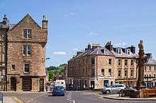
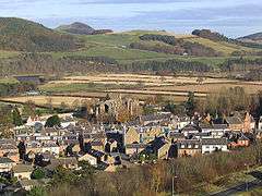
Today, the main towns in the county are (population in 2011):
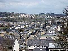
Hawick is now by far the largest town, with 29% of the county's population. More than half the population live in the two parishes of Hawick and Melrose.[6]
Administration
Today, Roxburghshire is within the Scottish Borders council area for local government purposes and contains the administrative centre of the area, the small town of Newtown St Boswells. It retains official status as a registration county, and falls within the Roxburgh, Ettrick and Lauderdale lieutenancy area for ceremonial purposes.
County
Until 1975, Roxburghshire was used for local government in Scotland, governed by a county council from 1890.
After the 1894 County Council, meetings were held at Newtown St Boswells, Kelso and Jedburgh until 1908 when Newtown St. Boswells became the headquarters for Roxburgh County Council. Roxburgh County Offices were built there around 1930. New buildings by Peter Womersley were opened in 1968 and after local government re-organisation (Local Government (Scotland) Act 1973) they became the headquarters of Borders Regions in 1975.[8] The Duke of Buccleuch and the Duke of Roxburghe between them held the convenorship of Roxburgh County Council for 43 years between 1900 and 1975.[9]
At the time of the county council's abolition it comprised four burghs and four districts:
- The royal burgh of Jedburgh
- The burghs of Hawick, Kelso and Melrose
- The County of Roxburgh Hawick, Jedburgh, Kelso and Melrose Districts.
District
The Local Government (Scotland) Act 1973 abolished the county council and incorporated its area into the Borders Region. Borders was divided into four districts, one of which was named Roxburgh. Roxburgh District consisted of the former county without most of the Melrose area (which was included in the new Ettrick and Lauderdale District), plus the parish of Nenthorn from Berwickshire. The regional and four district councils were abolished in 1996, merging to form the present Scottish Borders council area.
Coat of arms
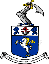
The County of Roxburgh was the first Scottish county to receive a grant of arms. This was made by Lord Lyon King of Arms on 9 July 1798. The coat of arms seems to have been granted for the use of the volunteer and militia units then being organised under the authority of the county's lord lieutenant. When the county council was formed in 1890, the arms passed to them.
The shield depicted a unicorn, a national symbol of Scotland. At the top of the shield was a hunting horn between two helmets: probably a reference to the border reivers, one of whom featured in the arms of the royal burgh of Jedburgh. The crest above the shield was an armoured arm brandishing a scimitar. The Latin motto was Ne Cede Malis Sed Contra Audentior Ito or Yield not to misfortunes (evil things) but go on more boldly against them., it was a quotation from Virgil's Aeneid 6, 95.[10]
On 6 May 1975 the coat of arms was regranted to Roxburgh District Council, without the crest.[11] When the district council was abolished in 1996, the arms reverted to The Crown.
Civil parishes

Following the boundary changes carried out under the Local Government (Scotland) Act 1889, the county of Roxburgh contained 30 civil parishes:
|
|
|
|
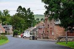
Settlements

- Abbotrule
- Ancrum
- Appletreehall
- Ashkirk
- Bairnkine
- Bedrule
- Bonchester Bridge
- Bowden
- Branxholme
- Broadhaugh
- Burnfoot
- Camptown
- Crailing
- Crailinghall
- Darnick
- Denholm
- Eckford
- Edgerston
- Ednam
- Eildon
- Galashiels (shared with Selkirkshire)
- Gattonside
- Hallrule
- Hawick
- Heiton
- Hobkirk
- Hownam
- Jedburgh
- Kelso
- Kirkton
- Kirk Yetholm
- Lempitlaw
- Lilliesleaf
- Lindean
- Linton
- Longnewton
- Maxton
- Melrose
- Midlem
- Minto
- Morebattle
- Newcastleton
- Newstead
- Newtown St Boswells
- Nisbet
- Oxnam
- Roxburgh
- St Boswells
- Smailholm
- Southdean
- Spittal-on-Rule
- Sprouston
- Stichill
- Town Yetholm
- Tweedbank
- Wilton
- Wilton Dean
Notable residents
- Robert Livingston the Elder, (1654–1728), born in Ancrum, was the Secretary for Indian affairs of the New York Province and the first lord of Livingston Manor.[12]
- Thomas Pringle the nineteenth century Scottish writer, poet and abolitionist was born at Blakelaw, a 500-acre (2.0 km2) farmstead four miles (6 km) to the south of the town of Kelso where his father was the tenant.
- "Chief" Robert Riddell (1820 - 1921), born in Teviotdale, was a Scottish-Canadian pioneer and veteran of the Upper Canada Rebellion. He is noted for having pioneered the township of Beverly in Ontario.
- Thomas B. Scott (1829 - 1886), President Pro Tem of the Wisconsin State Senate.
References
- Ordnance Gazetteer of Scotland, by, Francis Groome, publ. 2nd edition 1896. Article on Roxburghshire
- New Statistical Account of Scotland, Vol III Roxburgh, Peebles, Selkirk, publ.William Blackwood, 1845, p.430
- "Treaty of York – 1237". BBC. Retrieved 24 September 2017.
- Groome's Ordnance Gazetteer of Scotland, 2nd edition, published 1896. Article on Jedburgh
- "archive search". Retrieved 11 February 2019.
- Census of Scotland 2011, Table KS101SC – Usual Resident Population, published by National Records of Scotland. Web site http://www.scotlandscensus.gov.uk/ retrieved Feb 2016. See "Standard Outputs", Table KS101SC, Area type: Civil Parish 1930; calculated total for all Roxburghshire parishes
- Census of Scotland 2011, Table KS101SC – Usual Resident Population, published by National Records of Scotland. Web site http://www.scotlandscensus.gov.uk/ retrieved Feb 2016. See "Standard Outputs", Table KS101SC, Area type: Council Area
- Web site of Newtown News http://newtowneildon.weebly.com/council-hq.html retrieved March 2016
- Blossom: What Scotland Needs to Flourish, by Lesley Riddoch, chapter 7, pub. 2013
- R. M. Urquhart, Scottish Burgh and County Heraldry, London, 1973
- R. M. Urquhart, Scottish Civic Heraldry, London, 1979
- Who Was Who in America, Historical Volume, 1607-1896. Chicago: Marquis Who's Who. 1963.
- Edina.ac.uk, A Vision of Britain Through Time: Descriptive gazetteer entries for Roxburghshire