West Lothian Archaeological Trust
The West Lothian Archaeological Trust was formed on 19 April 2012 and registered as Scottish Charity[1] No. SC043118 on 26 April 2012, having been known informally, since 2007, as West Lothian (Aerial) Archaeology. The Trust also has an interest in sites in England, especially Gloucestershire[2]

In May 2013, the Trust was approved as an Associated Partner of ArcheoLandscapes Europe (ArcLand), part of the European Union's Culture Programme, to represent its area of expertise. Also in May, the Trust launched The Scottish National Aerial Photography Scheme (SNAPS) [3]
In 2016, the Trust became a member of the successor to ArcLand Europe, ArcLand International.
The Trust reverted to non-charitable status as West Lothian and Gloucestershire Aerial Archaeology in April 2019.
Goals of the Trust
The aims of the Charitable Trust, as officially registered, are for 'the advancement of heritage and science by
(a) Investigating (with emphasis on non-invasive techniques), recording and publicising (by publication and presentation) the archaeological/heritage sites of West Lothian, and elsewhere.
(b) Promoting the use of kite aerial photography as a low-cost, inclusive, environmentally friendly technique for archaeological/heritage photography and promoting the use of any other techniques which may be deemed appropriate by the Trustees.
(c) Running and maintaining an archaeological website as part of an associated community and heritage website.
Work of the Trust
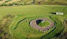
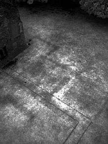
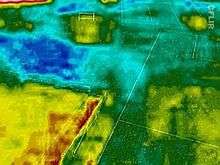
West Lothian Archaeology specialises in kite aerial photography (KAP) from the near ultra-violet through to the near and thermal infrared (Thermography). KAP is one of many techniques of aerial archaeology and was first used in an archaeological context by Henry Wellcome over 100 years ago. For a detailed consideration of kite aerial photography in the near-UV and near-IR, see the online publications of Geert Verhoeven which are listed in the external links below. On-site aerial photography complements the non-invasive methods of geophysical survey (archaeology) and images can be used to create virtual 3D models and animations.[4]
Kite aerial photography is a simple, cheap, technique. A Camera, or phone, is suspended on a kite line about 20m from the kite, on either a Picavet suspension (see Kite aerial photography) or using a simple selfie stick.
The work of the Trust was published on its Community and Heritage Website [5] and now on its Facebook page.[6]
The Trust maintains a register of specialist kite aerial photographers.[7]
%2C_Co_Roscommon%2C_Ireland.jpg)
References
- "Office of the Scottish Charity Regulator". Retrieved 2012-12-02.
- "Gloucestershire Aerial Archaeology".
- "The Scottish National Aerial Photography Scheme".
- "Low Altitude Aerial Photography and Visualisation of Heritage". Retrieved 2012-12-02.
- "West Lothian Archaeological Trust".
- "West Lothian Aerial Archaeology".
- "The Register of Kite Aerial Photographers and Kite Remote Sensing Specialists".
External links
| Wikimedia Commons has media related to West Lothian Archaeological Trust. |