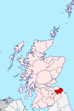
Berwickshire
Berwickshire is a historic county, registration county and lieutenancy area in the Scottish Borders. It takes its name from Berwick-upon-Tweed, which was part of Scotland at the time of the county's formation, but became part of England in 1482 after several centuries of being fought over and swapping back and forth between the two kingdoms.
Berwickshire | |
|---|---|
 | |
| Country | Scotland |
| County town | Berwick (historical) Greenlaw (1596–1890) Duns (modern) |
| Area | |
| • Total | 457 sq mi (1,184 km2) |
| Ranked 20th of 34 | |
| Chapman code | BEW |
Formerly the county was often called "the Merse", from Old English mǣres, "border". From 1596 to 1890 the county town was Greenlaw.[1] However, this was changed to Duns by the Local Government (Scotland) Act 1889, the act which established the system of county councils in Scotland.
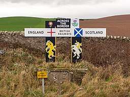
The county borders Midlothian to the west, East Lothian to the north, the North Sea to the east and Roxburghshire and the English county of Northumberland to the south.
Local government
Prior to 1975 Berwickshire contained four burghs and three districts:
- The royal burgh of Lauder
- The burgh of Coldstream
- The burgh of Duns
- The burgh of Eyemouth
The districts of:
- Berwick East
- Berwick Middle
- Berwick West
Berwickshire County Council was abolished by the Local Government (Scotland) Act 1973 and the county was instead governed by the Borders Regional Council.[2]
The region was divided into four districts, one of which was named Berwickshire District; however its area was not congruent with the county's, with the burgh of Lauder and most of the county's West District included in the Ettrick and Lauderdale District and the parish of Nenthorn included in the Roxburgh District. Berwickshire District Council remained based in Duns, the old county town.
The system of regions and districts was in turn abolished in 1996 in favour of unitary councils. Berwickshire is now governed by the unitary Scottish Borders Council.
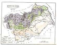
Geography
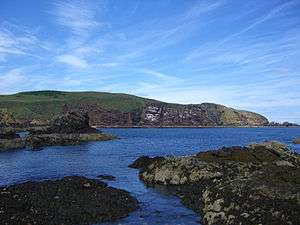
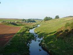
The terrain of Berwickshire is characterised by a series of low hills and agricultural land, with a number of small towns scattered throughout the county. The Lammermuir Hills traverse the border with East Lothian; it is here that Meikle Says Law, the highest point in the county at 535 m (1,755 ft), can be found. The River Tweed forms the border with England to the south, with the exception of a small section in the vicinity of Berwick-upon-Tweed (formerly the river formed the entirety of the border out to the North Sea); other major rivers include the Eye Water, Whiteadder Water, Dye Water, Watch Water, Eden Water and Blackadder Water.
Coat of arms
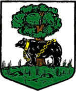
The county council of Berwickshire was formed in 1890 by the Local Government (Scotland) Act 1889, and applied for a grant of arms the same year. The grant, by Lord Lyon King of Arms was made on 10 October.
The coat of arms shows a bear chained to a wych elm tree, a pun on the county's name: bear + wych = Berwick.[3] In heraldry, this is known as a canting arms.
Upon the abolition of Berwickshire County Council, the arms were regranted to Berwickshire District Council.[4] When the district council was abolished the arms reverted to the Crown.
The coat of arms is featured on Berwickshire High School badge.
Transport
The East Coast Main Line railway line passes through the county parallel with the coast but does not stop here. The Berwickshire Railway formerly serviced the county, however this closed following damage caused by a violent storm in 1948.[5] The nearest open stations are in Dunbar and Berwick-upon-Tweed.
The A1 road runs roughly parallel to the railway and provides access to Edinburgh in the north and to the south Berwick-upon-Tweed, continuing on to Newcastle. The A68 and A697 serve the towns of western Berwickshire.
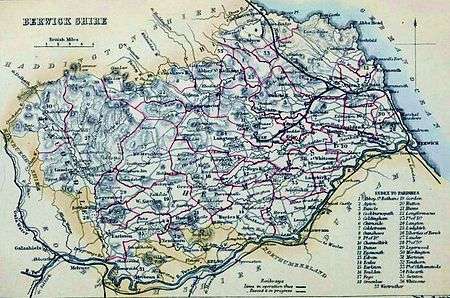
Civil parishes
- Abbey St Bathans
- Ayton
- Buncle (Bonkyl)
- Cockburnspath
- Coldingham
- Chirnside
- Coldstream
- Cranshaws
- Channelkirk
- Duns
- Eyemouth
- Edrom
- Eccles
- Earlston
- Foulden
- Fogo
- Greenlaw
- Gordon
- Hutton
- Hume
- Longformacus
- Langton
- Ladykirk
- Liberties of Berwick
- Lauder (former seat of the county Commissariat)
- Legerwood
- Mordington
- Mertoun
- Nenthorn
- Part of Oldhamstocks, since 1891 in East Lothian[6]
- Polwarth
- Swinton
- Whitsome
- Westruther
Settlements
- Abbey St Bathans
- Allanton
- Auchencrow
- Ayton
- Birgham
- Burnmouth
- Chirnside
- Clappers
- Clintmains
- Cockburnspath
- Coldingham
- Coldstream
- Cove
- Cranshaws
- Dryburgh
- Duns
- Earlston
- Eccles
- Edrom
- Eyemouth
- Fogo
- Foulden
- Gavinton
- Gordon
- Grantshouse
- Greenlaw
- Horndean
- Houndwood
- Hume
- Hutton
- Ladykirk
- Lamberton
- Lauder
- Legerwood
- Leitholm
- Lennel
- Longformacus
- Nenthorn
- Oxton
- Paxton
- Polwarth
- Preston
- Redpath
- Reston
- St Abbs
- Swinton
- Westruther
- Whitsome
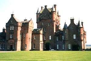 Ayton Castle
 Burnmouth
 Cranshaws
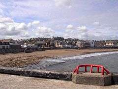 Eyemouth
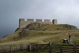 Hume Castle
Legacy
The Berwickshire News is published weekly, and numerous organisations and groups have Berwickshire in their titles (i.e.: the Berwickshire Housing Association, Berwickshire Sports Council).
The Berwickshire Civic Society is campaigned for road signs at the entrances to the county to have notices added saying 'You are now entering the ancient county of Berwickshire', and they hold an annual Keep Berwickshire Tidy Campaign, judged each April.
The High school west of Duns is named Berwickshire High School, it has been open since 1896. Together with Eyemouth High School they run a Rugby team under the name of Berwickshire schools.
The Berwickshire Coastal Path runs from Cockburnspath to Berwick-upon-Tweed (28 miles, 45 km).
References
- "Berwick-upon-Tweed - Braidwood | A Topographical Dictionary of Scotland (pp. 124-151)". British-history.ac.uk. 22 June 2003. Archived from the original on 27 September 2007. Retrieved 12 November 2012.
- Moffat, Alistair (2007), The Borders: a history of the Borders from earliest times, Edinburgh Birlinn, p. 551, ISBN 978-1-84158-466-9
- R.M. Urquhart (1973). Scottish Burgh and County Heraldry. London.
- R.M. Urquhart (1979). Scottish Civic Heraldry. London.
- John Thomas revised J S Paterson, A Regional History of the Railways of Great Britain: Volume 6, Scotland, the Lowlands and the Borders, David and Charles, Newton Abbot, 1984, ISBN 0 946537 12 7
- Prior to 1891 Oldhamstocks was partly in Berwickshire and had a detached portion at Butterdean of 1,417 acres (5.73 km2). The detached portion was transferred to Coldingham, while the main part of the parish is now wholly within East Lothian. See Ordnance Gazetteer of Scotland, by Francis Groome, 2nd Edition, 1896. Article on Oldhamstocks
External links
![]()
Local government areas of Scotland, in use 1973 to 1996 | ||
|---|---|---|
| Borders |  | |
| Central Region | ||
| Dumfries and Galloway | ||
| Fife | ||
| Grampian | ||
| Highland | ||
| Lothian | ||
| Strathclyde | ||
| Tayside | ||
| Island areas1 | ||