Waurika, Oklahoma
Waurika is the county seat of Jefferson County, Oklahoma, United States.[5] The population was 2,064 at the 2010 census, a 4.36 percent decrease from 2,158 at the 2000 census.[6]
Waurika, Oklahoma | |
|---|---|
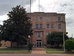 Jefferson County Courthouse in Waurika c. 2014 | |
| Motto(s): "Parakeet Capital of the World" | |
 Waurika  Waurika | |
| Coordinates: 34°10′12″N 98°0′5″W | |
| Country | United States |
| State | Oklahoma |
| County | Jefferson |
| Area | |
| • Total | 12.49 sq mi (32.36 km2) |
| • Land | 12.48 sq mi (32.33 km2) |
| • Water | 0.01 sq mi (0.03 km2) |
| Elevation | 896 ft (273 m) |
| Population (2010) | |
| • Total | 2,064 |
| • Estimate (2018)[2] | 1,934 |
| • Density | 154.93/sq mi (59.82/km2) |
| Time zone | UTC-6 (Central (CST)) |
| • Summer (DST) | UTC-5 (CDT) |
| ZIP code | 73573 |
| Area code(s) | 580 |
| FIPS code | 40-79250[3] |
| GNIS feature ID | 1099439[4] |
An article from 1985 in The Oklahoman claimed that Waurika promoted itself as "The Parakeet Capital of the World". It gave no explanation for using this slogan.[7]
City name
The name is the anglicized version of the Comanche compound woarɨhka ("worm eater") from woa ("worm") + tɨhka ("eat") and presumably refers to a group of Comanche living in the area or to some early European settlers whose plowing may have humorously resembled digging for worms.[8] Such humorous names were common in Comanche culture, such as the word for "rice", woarɨhkapɨh, literally "worm food".
History

Waurika was settled after the Comanche, Kiowa, and Apache Reservation was opened to non-Indians on August 6, 1901. The first white settler was James McGraw, who homesteaded on the present town site after moving from Burlington, Iowa.[9] The first sale of town lots was held on June 18, 1902. Nearly three thousand people attended the sale.[9]
Waurika was incorporated in May 1903. On May 8 of that year, C.A. McBrian was sworn in as the town's first mayor.[9] At the time of its founding, Waurika was located in Pickens County, Chickasaw Nation.[10]
The Chicago, Rock Island and Pacific Railway came to Waurika on January 1902 after the railroad superintendent "designated the town as a flag station."[9] Waurika was formerly the northern terminus for the Wichita Falls and Southern Railroad, one of the 20th century properties of Frank Kell and Joseph A. Kemp of Wichita Falls, Texas.[11]
| Historical population | |||
|---|---|---|---|
| Census | Pop. | %± | |
| 1910 | 2,928 | — | |
| 1920 | 3,204 | 9.4% | |
| 1930 | 2,368 | −26.1% | |
| 1940 | 2,458 | 3.8% | |
| 1950 | 2,327 | −5.3% | |
| 1960 | 1,933 | −16.9% | |
| 1970 | 1,833 | −5.2% | |
| 1980 | 2,369 | 29.2% | |
| 1990 | 2,088 | −11.9% | |
| 2000 | 2,158 | 3.4% | |
| 2010 | 2,064 | −4.4% | |
| Est. 2018 | 1,934 | [2] | −6.3% |
| [6][9] | |||
Geography
Waurika is located in northwestern Jefferson County at 34°10′12″N 98°0′5″W (34.170130, -98.001268).[12] U.S. Route 70 passes through the southern side of the city, leading east 49 miles (79 km) to Ardmore and west 27 miles (43 km) to Randlett. U.S. Route 81 crosses US 70 in the southeastern corner of Waurika, leading north 26 miles (42 km) to Duncan and south 24 miles (39 km) to Ringgold. Oklahoma State Highway 5 (Waurika's Main Street) leads northwest 19 miles (31 km) to Temple. Waurika is about 109 miles (175 km) southwest of Oklahoma City.[9]
According to the United States Census Bureau, Waurika has a total area of 12.5 square miles (32.4 km2), of which 0.01 square miles (0.03 km2), or 0.08%, are water.[13] The city center lies on the east side of the valley of Beaver Creek, a south-flowing tributary of the Red River.
Waurika Lake is 6 miles (10 km) northwest of the city center.[14]
Economy
Waurika's economy has largely been based on cattle raising, agriculture and petroleum production since the founding of the city.[9]
Demographics
As of the census[3] of 2000, there were 1,988 people, 741 households, and 500 families residing in the city. The population density was 168.0 people per square mile (64.9/km²). There were 929 housing units at an average density of 78.5 per square mile (30.3/km²). The racial makeup of the city was 85.41% White, 1.81% African American, 4.28% Native American, 3.37% Asian, 0.10% Pacific Islander, 2.36% from other races, and 2.67% from two or more races. Hispanic or Latino of any race were 8.00% of the population.
There were 741 households out of which 28.5% had children under the age of 18 living with them, 54.1% were married couples living together, 9.9% had a female householder with no husband present, and 32.4% were non-families. 30.5% of all households were made up of individuals and 17.3% had someone living alone who was 65 years of age or older. The average household size was 2.35 and the average family size was 2.89.
In the city, the population was spread out with 22.3% under the age of 18, 7.5% from 18 to 24, 29.1% from 25 to 44, 20.6% from 45 to 64, and 20.5% who were 65 years of age or older. The median age was 39 years. For every 100 females, there were 107.3 males. For every 100 females age 18 and over, there were 107.9 males.
The median income for a household in the city was $23,800, and the median income for a family was $31,594. Males had a median income of $24,844 versus $16,286 for females. The per capita income for the city was $13,496. About 6.4% of families and 12.2% of the population were below the poverty line, including 14.4% of those under age 18 and 17.4% of those age 65 or over.
Government
Waurika has a home rule charter form of government.[9]
Notable people
- Bennie G. Adkins, United States Army Medal of Honor recipient born in Waurika
- Irene Champlin, actress born in Waurika
- Gary Chapman, singer and songwriter born in Waurika
Places
There is a Chisholm Trail Historical Museum in Waurika.
Notable events
The 1996 murder of Heather Rich brought notoriety to Waurika. Rich, a 16-year-old sophomore at the local high school, was murdered by two classmates and an acquaintance in a case that attracted national media coverage.
References
- "2018 U.S. Gazetteer Files". United States Census Bureau. Retrieved Feb 12, 2020.
- "Population and Housing Unit Estimates". Retrieved June 4, 2019.
- "U.S. Census website". United States Census Bureau. Retrieved 2008-01-31.
- "US Board on Geographic Names". United States Geological Survey. 2007-10-25. Retrieved 2008-01-31.
- "Find a County". National Association of Counties. Retrieved 2011-06-07.
- "Census Viewer: Waurika, Oklahoma Population". Moonshadow Mobile, Inc. Retrieved February 18, 2016.
- Etter, Jim. "Catchy Slogans Strive to Put Towns on Map." The Oklahoman. October 20, 1985. Accessed November 3, 2016.
- William Bright. 2013. Native American Placenames of the Southwest (Univ. of Oklahoma Press)
- Sheridan B. Drowatzky, "Waurika," Encyclopedia of Oklahoma History and Culture, 2009. Accessed March 27, 2015.
- Charles Goins, Historical Atlas of Oklahoma (Norman: University of Oklahoma Press, 2006), plate 105.
- "H. Allen Anderson, "Wichita Falls and Southern Railroad"". tshaonline.org. Retrieved April 19, 2013.
- "US Gazetteer files: 2010, 2000, and 1990". United States Census Bureau. February 12, 2011. Retrieved April 23, 2011.
- "Geographic Identifiers: 2010 Census Summary File 1 (G001): Waurika city, Oklahoma". American Factfinder. U.S. Census Bureau. Archived from the original on February 13, 2020. Retrieved October 17, 2018.
- Google Maps
Municipalities and communities of Jefferson County, Oklahoma, United States | ||
|---|---|---|
| City | 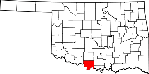 Jefferson County map | |
| Towns | ||
| Unincorporated communities | ||
| Authority control |
|
|---|