Oklahoma State Highway 5
State Highway 5 (SH-5 or OK-5) is the name assigned to two distinct state highways in the U.S state of Oklahoma. One runs for 20.42 miles (32.86 km)[1][2] through extreme southwestern Oklahoma, passing through Harmon and Jackson Counties. The other is 98.2 miles (158.0 km)[3] long and runs through southwest Oklahoma, connecting US-283 south of Altus to US-70 at Waurika.
| ||||
|---|---|---|---|---|
 | ||||
| Route information | ||||
| Maintained by ODOT | ||||
| Section 1 | ||||
| Length | 20.42 mi[1][2] (32.86 km) | |||
| West end | ||||
| East end | ||||
| Section 2 | ||||
| Length | 98.2 mi[3] (158.0 km) | |||
| West end | ||||
| East end | ||||
| Highway system | ||||
Oklahoma State Highway System
| ||||

Route description
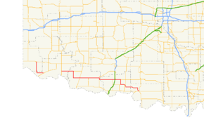
Western section

The western SH-5 begins at U.S. Highway 62 in Gould, Oklahoma and runs south until just past Lincoln, where it turns east. It then ends at State Highway 6 in Eldorado, just seven miles (11 km) north of the Texas border.
The western SH-5 was once known as SH-90.
Both the now-separate western and eastern sections of SH-5 were formerly part of a continuous SH-5 across Southwest Oklahoma. From 1958 to 1969, SH-5 continued east from Eldorado over an unpaved roadway to a junction with US-283 east of Elmer, and then turned north on a route shared with US-283 to the current west terminus of the eastern SH-5 at its junction with US-283 south of Altus and west of Tipton and continued east over the current eastern SH-5. The former Eldorado to Elmer section of SH-5 was removed from the state highway system in 1969 and continues in use as a county road under the jurisdiction of Jackson County.
Eastern section
The eastern SH-5 starts between Altus and Elmer at US-283. It heads east from here to Tipton, where it turn south and SH-5C splits off. South of Tipton, SH-5 turns east again to intersect U.S. Highway 183 in Frederick. 19 miles (30.5 km) later, it has a two-mile (3.2 km) concurrency with State Highway 36. The highway splits off to the east from here, sharing a three-mile (4.8 km) concurrency with US-277/281 and an interchange with Interstate 44 (which is also the Walters toll plaza of the H.E. Bailey Turnpike).
Five miles (8 km) east of where this three-route concurrency breaks up, SH-5 turns south in Walters, with the mainline being taken over by State Highway 53. SH-5 heads east again toward Temple, where it has a brief concurrency with State Highway 65, and then turns southeast to pass through Hastings before ending at US-70 in Waurika.
Spurs
SH-5 has three lettered spur routes.
- SH-5A connects SH-5 south of Walters to US-277/281 south of Cookietown.
- SH-5B does not connect directly with SH-5. It runs from SH-5A south to US-70 at Taylor.
- SH-5C runs from SH-5 at Tipton to US-183 in Manitou.
Junction list
Western section
| County | Location | mi[1][2] | km | Destinations | Notes |
|---|---|---|---|---|---|
| Harmon | Gould | 0.00 | 0.00 | Western terminus | |
| Jackson | Eldorado | 20.42 | 32.86 | Eastern terminus | |
| 1.000 mi = 1.609 km; 1.000 km = 0.621 mi | |||||
Eastern section
| County | Location | mi[3] | km | Destinations | Notes |
|---|---|---|---|---|---|
| Jackson | | 0.0 | 0.0 | Western terminus | |
| Tillman | Tipton | 11.5 | 18.5 | Western terminus of SH-5C | |
| Frederick | 25.9 | 41.7 | |||
| | 34.2 | 55.0 | Northern terminus of SH-54 | ||
| | 45.1 | 72.6 | Northern end of SH-36 concurrency | ||
| | 46.8 | 75.3 | Southern end of SH-36 concurrency | ||
| Cotton | | 60.2 | 96.9 | Western end of US-277 / US-281 concurrency | |
| | 62.6 | 100.7 | I-44 exit 20 | ||
| | 63.1 | 101.5 | Eastern end of US-277 / US-281 concurrency | ||
| Walters | 68.1 | 109.6 | Western terminus of SH-53 | ||
| | 74.1 | 119.3 | Eastern terminus of SH-5A | ||
| Temple | 78.1 | 125.7 | Western end of SH-65 concurrency | ||
| 78.6 | 126.5 | Eastern end of SH-65 concurrency | |||
| Jefferson | Waurika | 98.2 | 158.0 | Eastern terminus | |
1.000 mi = 1.609 km; 1.000 km = 0.621 mi
| |||||
References
- Oklahoma Department of Transportation (n.d.). Control Section Maps: Harmon County (PDF) (Map) (2010–2011 ed.). Scale not given. Oklahoma City: Oklahoma Department of Transportation. Retrieved November 30, 2012.
- Oklahoma Department of Transportation (n.d.). Control Section Maps: Jackson County (PDF) (Map) (2010–2011 ed.). Scale not given. Oklahoma City: Oklahoma Department of Transportation. Retrieved November 30, 2012.
- Google (December 1, 2012). "Oklahoma State Highway 5" (Map). Google Maps. Google. Retrieved December 1, 2012.