Poteau, Oklahoma
Poteau (/ˈpoʊtoʊ/ POH-toh) is a city in, and county seat of, Le Flore County, Oklahoma, United States.[6] The population was 8,520 as of the 2010 census.[2]
Poteau, Oklahoma | |
|---|---|
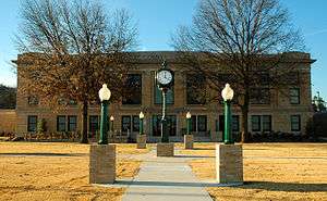 The LeFlore County Courthouse is one of five sites in Poteau listed on the National Register of Historic Places | |
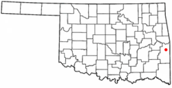 Location of Poteau, Oklahoma | |
| Coordinates: 35°3′31″N 94°37′48″W | |
| Country | United States |
| State | Oklahoma |
| County | Le Flore |
| Government | |
| • Mayor | Scott White |
| Area | |
| • Total | 32.63 sq mi (84.50 km2) |
| • Land | 30.15 sq mi (78.09 km2) |
| • Water | 2.47 sq mi (6.41 km2) |
| Elevation | 489 ft (149 m) |
| Population | |
| • Total | 8,520 |
| • Estimate (2018)[3] | 8,914 |
| • Density | 295.65/sq mi (114.15/km2) |
| Time zone | UTC-6 (Central (CST)) |
| • Summer (DST) | UTC-5 (CDT) |
| ZIP code | 74953 |
| Area code(s) | 539/918 |
| FIPS code | 40-60350[4] |
| GNIS feature ID | 1096874[5] |
| Website | City of Poteau |
History
In 1719, Bernard de la Harpe led a group of French explorers through this area and gave the river its present name. The present day city was founded in 1885, its name being derived from the nearby Poteau River.[7] During the late 1700s, there was a large French outpost at Belle Point (Ft. Smith). From there, they would travel up the Poteau River to the base of Cavanal Mountain where a secondary post was established. Because of this, the river was named the "Post River", or Poteau River, and the outpost was simply called the post, or "Poteau".[8] A group of French explorers gave the river its present name during the early 18th Century. Poteau is a French word meaning post.[9]
The Poteau Chamber of Commerce has written that the community was founded in 1885 as a few houses and Bud Tate's general store. At the time of its founding, Poteau was located in Sugar Loaf County, a part of the Moshulatubbee District of the Choctaw Nation.[10]. It was incorporated as a town in the Indian Territory by the federal government on October 8, 1898. The first stone public building, a school, was built in the same year.[7]
The Fort Smith and Southern Railway built a rail line through the Poteau area in 1886–1887, en route to Paris, Texas, including a station within the city itself. The Poteau post office opened in 1887 and the Kansas City, Pittsburg and Gulf Railroad (acquired by the Kansas City Southern Railway in 1900) began serving the town in 1896.[9]
In 1900, the Federal Court of Indian Territory was moved from Cameron, Oklahoma to Poteau. The Poteau News was first published in 1905. Other modern improvements during the run-up to statehood included: The Bank of Poteau in 1901 (which became a national bank in 1904), and the First Bank of Poteau in 1904. [lower-alpha 1] A telephone company franchise was granted in 1904, and an electric utility and waterworks system was begun in 1906.[7]
After statehood, Governor Charles N. Haskell declared Poteau as a, "... city of the first class."[7]
Geography

According to the United States Census Bureau, the city has a total area of 31.7 square miles (82 km2), of which 28.6 square miles (74 km2) is land and 3.0 square miles (7.8 km2), or 9.54%, is water. It is about 12 miles (19 km) west of the Oklahoma-Arkansas border.[9]
The city is located in the valley below Cavanal Hill, dubbed the "World's Highest Hill" as it is 1,999 feet high, although it was measured from the top of the LeFlore County Courthouse, not sea level.
The Poteau River, the only river in Oklahoma that flows north, is located near the city. It flows into Arkansas where it meets with the Arkansas River at Belle Point in Fort Smith.
Demographics
| Historical population | |||
|---|---|---|---|
| Census | Pop. | %± | |
| 1900 | 1,182 | — | |
| 1910 | 1,830 | 54.8% | |
| 1920 | 2,679 | 46.4% | |
| 1930 | 3,169 | 18.3% | |
| 1940 | 4,020 | 26.9% | |
| 1950 | 4,776 | 18.8% | |
| 1960 | 4,428 | −7.3% | |
| 1970 | 5,500 | 24.2% | |
| 1980 | 7,089 | 28.9% | |
| 1990 | 7,210 | 1.7% | |
| 2000 | 7,939 | 10.1% | |
| 2010 | 8,520 | 7.3% | |
| Est. 2018 | 8,914 | [3] | 4.6% |
| U.S. Decennial Census[11] 2014 Estimate[12] | |||
As of the census[4] of 2000, there were 7,939 people, 3,013 households, and 2,042 families residing in the city. The population density was 277.2 people per square mile (107.0/km²). There were 3,351 housing units at an average density of 117.0 per square mile (45.2/km²). The racial makeup of the city was 82.14% White, 2.24% African American, 10.00% Native American, 0.38% Asian, 0.03% Pacific Islander, 1.39% from other races, and 3.83% from two or more races. Hispanic or Latino of any race were 5.82% of the population.
There were 3,013 households out of which 31.6% had children under the age of 18 living with them, 50.0% were married couples living together, 13.3% had a female householder with no husband present, and 32.2% were non-families. 28.3% of all households were made up of individuals and 14.9% had someone living alone who was 65 years of age or older. The average household size was 2.48 and the average family size was 3.02.
In the city, the population was spread out with 24.6% under the age of 18, 12.8% from 18 to 24, 26.4% from 25 to 44, 19.9% from 45 to 64, and 16.3% who were 65 years of age or older. The median age was 35 years. For every 100 females, there were 91.0 males. For every 100 females age 18 and over, there were 88.3 males.
The median income for a household in the city was $26,178, and the median income for a family was $31,226. Males had a median income of $24,595 versus $20,625 for females. The per capita income for the city was $15,175. About 19.3% of families and 22.1% of the population were below the poverty line, including 31.8% of those under age 18 and 13.4% of those age 65 or over.
Education
The Poteau Public School System includes Poteau Primary School, Poteau Upper Elementary School, Pansy Kidd Middle School and Poteau Senior High School.[13] Pansy Kidd Middle School is named in honor of Pansy Ingle Kidd (1890–1978), who taught in Poteau for over 40 years and was nicknamed the "Dean of Poteau's Teachers."[14]
In 1955, Dr. John Montgomery, a black veterinarian, petitioned the Poteau Public School Board to eliminate the racial segregation of its schools.[15] The board approved his petition, resulting in the integration of the school system and marking Poteau as the first city in Oklahoma to allow African Americans to learn alongside white students in its primary and secondary schools.[15]
Carl Albert State College, formerly known as Poteau Junior College, is one of the 13 state colleges found in Oklahoma.
Kiamichi Technology Center, the largest division of the Oklahoma CareerTech System has a branch location in Poteau.
Government
Poteau has a mayor-council type of city government, with eight members on the council. The mayor and council members are elected by the citizens to four-year terms. The city Police Department consists of a chief, elected by citizen voters and 12 officers who report to the chief. The city has an all-volunteer fire department, which has a fire chief, an assistant chief, captain and 13 firemen.[7]
The LeFlore County Sheriff's office is in Poteau, and contains six highway patrol officers and an inspector.[7]
Climate
Poteau is tied with several other towns for the highest recorded temperature in the state of Oklahoma.[16]
| Climate data for Poteau, OK | |||||||||||||
|---|---|---|---|---|---|---|---|---|---|---|---|---|---|
| Month | Jan | Feb | Mar | Apr | May | Jun | Jul | Aug | Sep | Oct | Nov | Dec | Year |
| Record high °F (°C) | 84 (29) |
85 (29) |
92 (33) |
95 (35) |
100 (38) |
110 (43) |
113 (45) |
120 (49) |
110 (43) |
101 (38) |
88 (31) |
83 (28) |
120 (49) |
| Average high °F (°C) | 52.5 (11.4) |
57.0 (13.9) |
65.1 (18.4) |
75.0 (23.9) |
81.7 (27.6) |
89.7 (32.1) |
95.3 (35.2) |
95.3 (35.2) |
88.2 (31.2) |
78.1 (25.6) |
64.5 (18.1) |
55.4 (13.0) |
74.8 (23.8) |
| Average low °F (°C) | 29.4 (−1.4) |
33.5 (0.8) |
41.2 (5.1) |
50.7 (10.4) |
58.3 (14.6) |
66.5 (19.2) |
70.4 (21.3) |
69.6 (20.9) |
62.2 (16.8) |
51.1 (10.6) |
39.8 (4.3) |
32.8 (0.4) |
50.5 (10.3) |
| Record low °F (°C) | −7 (−22) |
−7 (−22) |
7 (−14) |
21 (−6) |
34 (1) |
46 (8) |
49 (9) |
49 (9) |
33 (1) |
23 (−5) |
10 (−12) |
−6 (−21) |
−7 (−22) |
| Average precipitation inches (mm) | 2.52 (64) |
3.02 (77) |
3.65 (93) |
4.63 (118) |
5.89 (150) |
3.89 (99) |
3.42 (87) |
3.00 (76) |
3.84 (98) |
3.53 (90) |
3.73 (95) |
3.02 (77) |
44.14 (1,124) |
| Average snowfall inches (cm) | 2.1 (5.3) |
2.3 (5.8) |
0.3 (0.76) |
0 (0) |
0 (0) |
0 (0) |
0 (0) |
0 (0) |
0 (0) |
0 (0) |
0.1 (0.25) |
0.6 (1.5) |
5.4 (13.61) |
| Source: http://www.wrcc.dri.edu/cgi-bin/cliMAIN.pl?ok7246 | |||||||||||||
Notable people
- Rilla Askew – writer
- Kenneth Corn – former Oklahoma State Senator and Oklahoma State Representative who was a candidate for Lieutenant Governor of Oklahoma in 2010.
- Ron Fortner – radio and television anchor.
- Argus Hamilton - Comedian and national columnist
- Billy Hoffman – country music singer; raised in Poteau.
- Robert S. Kerr - now deceased, the late U.S. senator owned a home and cattle ranch in the Poteau area[7]
- Mick Thompson – current Oklahoma State Banking Commissioner and former Oklahoma State Representative.
- Jackson Burns – Actor, writer, producer and stunt coordinator.
Notes
- Together, the two banks had deposits estimated at $50,000 each.[9]
See also
References
- "2018 U.S. Gazetteer Files". United States Census Bureau. Retrieved Feb 12, 2020.
- "U.S. Census website". United States Census Bureau. Retrieved 2014-08-29.
- "Population and Housing Unit Estimates". Retrieved June 4, 2019.
- "U.S. Census website". United States Census Bureau. Retrieved 2008-01-31.
- "US Board on Geographic Names". United States Geological Survey. 2007-10-25. Retrieved 2008-01-31.
- "Find a County". National Association of Counties. Retrieved 2011-06-07.
- "History". City of Poteau, Oklahoma. Retrieved 7 July 2014.
- Standridge, Eric (June 20, 2012). The Birth of Poteau. Standridge and Shaw Publishing. p. 15. ISBN 1477603476.
- Harold Crain, "Poteau," Encyclopedia of Oklahoma History and Culture. Accessed March 20, 2015.
- Morris, John W. Historical Atlas of Oklahoma (Norman: University of Oklahoma, 1986), plate 38.
- United States Census Bureau. "Census of Population and Housing". Retrieved August 28, 2014.
- "Population Estimates". United States Census Bureau. Archived from the original on May 22, 2015. Retrieved May 30, 2015.
- "Welcome to Poteau Public Schools," Poteau Public Schools, accessed March 25, 2015.
- "History of Our School". Pansy Kidd Middle School. Retrieved 2008-09-20.
- Curtis, Gene. "Only in Oklahoma: Vet brought desegregation to 'Little Dixie'," Tulsa World, October 7, 2007. Accessed March 25, 2015.
- Enloe. "State Climate Extremes Committee (SCEC) | Extremes | National Centers for Environmental Information (NCEI)". www.ncdc.noaa.gov. Retrieved 2017-04-11.
External links
| Wikivoyage has a travel guide for Poteau. |
- City of Poteau
- Poteau Chamber of Commerce
- Downtown Poteau
- The Poteau Improvement Project
- Patrick Lynch Public Library
- Carl Albert State College
- Oklahoma Digital Maps: Digital Collections of Oklahoma and Indian Territory
Municipalities and communities of Le Flore County, Oklahoma, United States | ||
|---|---|---|
| Cities |  Le Flore County map | |
| Towns | ||
| CDP | ||
| Other unincorporated communities | ||
| Footnotes | ‡This populated place also has portions in an adjacent county or counties | |
| Authority control |
|---|