Idabel, Oklahoma
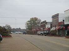
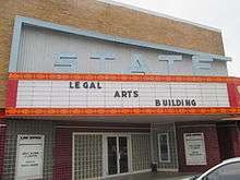
Idabel is a city in and county seat of McCurtain County, Oklahoma, United States. The population was 7,010 at the 2010 census.[5] It is located in the southeast corner of Oklahoma, a tourist area known as McCurtain Country.
Idabel, Oklahoma | |
|---|---|
.jpg) Idabel City Hall | |
| Nickname(s): Dogwood Capital of Oklahoma | |
 Location of Idabel, Oklahoma | |
| Coordinates: 33°53′44″N 94°49′35″W[1] | |
| Country | United States |
| State | Oklahoma |
| County | McCurtain |
| Government | |
| • Type | Mayor-council |
| Area | |
| • Total | 17.00 sq mi (44.03 km2) |
| • Land | 16.88 sq mi (43.72 km2) |
| • Water | 0.12 sq mi (0.31 km2) |
| Elevation | 472 ft (144 m) |
| Population (2010) | |
| • Total | 7,010 |
| • Estimate (2018)[3] | 6,838 |
| • Density | 405.07/sq mi (156.40/km2) |
| Time zone | UTC-6 (Central (CST)) |
| • Summer (DST) | UTC-5 (CDT) |
| ZIP code | 74745 |
| Area code(s) | 580 |
| FIPS code | 40-36750 [4] |
| GNIS feature ID | 1101480 [1] |
| Website | www |
History
.jpg)
Idabel was established in 1902 by the Arkansas and Choctaw Railway (later part of the St. Louis and San Francisco Railway (Frisco)). The city was first named Purnell, after Isaac Purnell, a railroad official. When postal officials rejected that designation, the name was changed to Mitchell, honoring another railroad company officer. Postal officials also rejected because another post office of that name existed elsewhere in the territory. They named the post office Bokhoma (a Choctaw word meaning Red River), which opened December 15, 1902. Railroad officials then chose the name Idabel, a compound of the names of Isaac Purnell's two daughters, Ida and Bell. The post office was then renamed Idabel.[6]
At the time of its founding, Idabel was located in Bok Tuklo County, a part of the Apukshunubbee District of the Choctaw Nation.[7]
For its first four years, Idabel local government was the responsibility of the Choctaw tribe for the Indians themselves. The national government was responsible for enforcing the law among non-Choctaws. In 1906, the citizens elected their first mayor and established a mayor-council form of government. At the time of statehood, November 16, 1907, the town was designated as the county seat of McCurtain County. A census in that year reported 726 residents. By 1910, the population had grown to 1,493. In 1920, there were 3,617 residents, but the number fell to 2,581 in 1930. Growth resumed by the end of the Great Depression in the late 1930s.
Idabel residents elected their first African American mayor in April 2019, mayor Craig Young. [6]
Geography
Idabel lies between the Little River and the Red River, approximately 21 miles (34 km) west of the Oklahoma-Arkansas state line and 40 miles (64 km) east of Hugo.[6] U.S. Routes 70 and 259 pass through the city.[8]
According to the United States Census Bureau, the city has a total area of 15.9 square miles (41 km2), of which 15.9 square miles (41 km2) is land and 0.06% is water.[9]
Climate
The climate in this area is characterized by hot, humid summers and generally mild to cool winters. According to the Köppen Climate Classification system, Idabel has a humid subtropical climate, abbreviated "Cfa" on climate maps.[10]
| Climate data for Idabel, OK 1981-2010, extremes 1907-2017 | |||||||||||||
|---|---|---|---|---|---|---|---|---|---|---|---|---|---|
| Month | Jan | Feb | Mar | Apr | May | Jun | Jul | Aug | Sep | Oct | Nov | Dec | Year |
| Record high °F (°C) | 87 (31) |
89 (32) |
94 (34) |
97 (36) |
99 (37) |
107 (42) |
111 (44) |
114 (46) |
109 (43) |
101 (38) |
89 (32) |
82 (28) |
114 (46) |
| Average high °F (°C) | 53.4 (11.9) |
59.0 (15.0) |
66.5 (19.2) |
74.0 (23.3) |
81.2 (27.3) |
88.5 (31.4) |
92.7 (33.7) |
93.6 (34.2) |
86.0 (30.0) |
76.0 (24.4) |
64.9 (18.3) |
55.2 (12.9) |
74.3 (23.5) |
| Average low °F (°C) | 29.0 (−1.7) |
34.0 (1.1) |
41.1 (5.1) |
47.9 (8.8) |
58.3 (14.6) |
66.7 (19.3) |
70.1 (21.2) |
69.4 (20.8) |
61.5 (16.4) |
50.2 (10.1) |
40.1 (4.5) |
31.4 (−0.3) |
50.0 (10.0) |
| Record low °F (°C) | −6 (−21) |
−11 (−24) |
9 (−13) |
21 (−6) |
31 (−1) |
45 (7) |
53 (12) |
49 (9) |
36 (2) |
23 (−5) |
11 (−12) |
−2 (−19) |
−11 (−24) |
| Average precipitation inches (mm) | 3.14 (80) |
4.05 (103) |
4.87 (124) |
4.12 (105) |
6.37 (162) |
4.25 (108) |
3.87 (98) |
2.69 (68) |
4.15 (105) |
5.59 (142) |
5.12 (130) |
4.79 (122) |
53.01 (1,347) |
| Average snowfall inches (cm) | 0.6 (1.5) |
0.9 (2.3) |
0.2 (0.51) |
0.0 (0.0) |
0.0 (0.0) |
0.0 (0.0) |
0.0 (0.0) |
0.0 (0.0) |
0.0 (0.0) |
0.0 (0.0) |
0.0 (0.0) |
0.1 (0.25) |
1.8 (4.56) |
| Average precipitation days (≥ 0.01 in) | 8 | 8 | 9 | 8 | 10 | 8 | 7 | 6 | 7 | 9 | 8 | 9 | 97 |
| Average snowy days (≥ 0.1 in) | 0.3 | 0.3 | 0.1 | 0.0 | 0.0 | 0.0 | 0.0 | 0.0 | 0.0 | 0.0 | 0.1 | 0.1 | 0.9 |
| Source: NWS Nowdata for Idabel (Shreveport Area) | |||||||||||||
Demographics
| Historical population | |||
|---|---|---|---|
| Census | Pop. | %± | |
| 1910 | 1,493 | — | |
| 1920 | 3,067 | 105.4% | |
| 1930 | 2,581 | −15.8% | |
| 1940 | 3,689 | 42.9% | |
| 1950 | 4,671 | 26.6% | |
| 1960 | 4,967 | 6.3% | |
| 1970 | 5,946 | 19.7% | |
| 1980 | 7,622 | 28.2% | |
| 1990 | 6,957 | −8.7% | |
| 2000 | 7,658 | 10.1% | |
| 2010 | 7,010 | −8.5% | |
| Est. 2018 | 6,838 | [3] | −2.5% |
| U.S. Decennial Census | |||
As of the census[4] of 2000, there were 7,658 people, 2,735 households, and 1,785 families residing in the city. The population density was 436.3 people per square mile (168.5/km²). There were 3,129 housing units at an average density of 196.4 per square mile (75.8/km²). The racial makeup of the city was 56.99% White, 24.45% African American, 10.44% Native American, 0.30% Asian, 0.01% Pacific Islander, 3.37% from other races, and 4.43% from two or more races. Hispanic or Latino of any race were 4.96% of the population.
There were 2,735 households out of which 34.4% had children under the age of 18 living with them, 39.6% were married couples living together, 21.2% had a female householder with no husband present, and 34.7% were non-families. 31.6% of all households were made up of individuals and 12.9% had someone living alone who was 65 years of age or older. The average household size was 2.45 and the average family size was 3.08.
In the city, the population was spread out with 29.5% under the age of 18, 9.2% from 18 to 24, 26.0% from 25 to 44, 20.7% from 45 to 64, and 14.6% who were 65 years of age or older. The median age was 34 years. For every 100 females, there were 85.6 males. For every 100 females age 18 and over, there were 81.0 males.
The median income for a household in the city was $20,496, and the median income for a family was $24,189. Males had a median income of $24,182 versus $16,958 for females. The per capita income for the city was $12,241. About 28.7% of families and 31.3% of the population were below the poverty line, including 42.5% of those under age 18 and 18.4% of those age 65 or over.
Economy
Initially, timber was the basis for the local economy, but this was supplanted by cotton production after the nearby forests were cleared. One cotton gin operated in Idabel in 1904, but six were in business in 1930. However, the Great Depression, depleted soil and destructive pests essentially wiped out this industry around Idabel. Landowners converted their properties to pastures and expanded beef production. Chicken farms were also established in the area and marginal agricultural land was turned into pine plantations.[6]
Education
.jpg)
.jpg)
Public schools
Idabel Public Schools serves the community.
- Idabel High School - Grades 9–12
- Idabel Middle School - Grades 6–8
- Central Elementary - Grades 3–5
- Idabel Primary South - Grades 1–2 PRE-K–K
- EvenStart - Ages 2–4
- Southeast Elementary - pre-k–4–Adult Ed
- Denison Elementary - Pre-Kindergarten - 8th
Advanced education
- Kiamichi Technology Center
- Southeastern Oklahoma State University, McCurtain County campus (formerly called the ET Dunlap Center)
- Eastern Oklahoma State College
Notable people
- Vice Admiral Phillip Balisle, United States Navy[11]
- Randall Burks, former professional football player[12]
- Ray Burris, professional baseball player
- Hadley Caliman, jazz musician[13]
- Earl Grant, organist
- Jeff Keith, lead singer for the rock band Tesla[14]
- Sunny Murray, jazz drummer, composer and band leader
- Harold Stevenson, artist (1929-2018)
- Countess Vaughn, actress[15]
References
- U.S. Geological Survey Geographic Names Information System: Idabel, Oklahoma
- "2018 U.S. Gazetteer Files". United States Census Bureau. Retrieved Feb 12, 2020.
- "Population and Housing Unit Estimates". Retrieved June 4, 2019.
- "U.S. Census website". United States Census Bureau. Retrieved 2008-01-31.
- "Find a County". National Association of Counties. Archived from the original on 2011-05-31. Retrieved 2011-06-07.
- Coleman, Louis. "Idabel," Encyclopedia of Oklahoma History and Culture Oklahoma Historical Society, Accessed September 3, 2015.
- Morris, John W. Historical Atlas of Oklahoma (Norman: University of Oklahoma, 1986), plate 38.
- Oklahoma Atlas & Gazetteer, DeLorme, 1st ed., 1998, p.67 ISBN 0899332838
- "US Gazetteer files: 2010, 2000, and 1990". United States Census Bureau. 2011-02-12. Retrieved 2011-04-23.
- Climate Summary for Idabel, Oklahoma
- Nagel, David. "Vice Adm. Phillip Balisle Takes Helm at NAVSEA". Naval Sea Systems Command Public Affairs. United States Navy. Retrieved 9 May 2017.

- The 10 Best and Worst One-Game Careers in NFL History, Bleacher Report. (accessed October 14, 2013)
- All About Jazz - Hadley Caliman
- Tesla, Allmusic.com. (accessed October 13, 2013)
- Countess Vaughn, Internet Movie Database. (accessed October 14, 2013)
External links
- Idabel Public Library
- Idabel Public Schools
- McCurtain County OSU Extension Center
- Encyclopedia of Oklahoma History and Culture - Idabel
Municipalities and communities of McCurtain County, Oklahoma, United States | ||
|---|---|---|
| Cities | 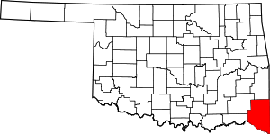 Map of Oklahoma highlighting McCurtain County | |
| Towns | ||
| CDP | ||
| Other unincorporated communities |
| |
| Ghost towns | ||
| Authority control |
|
|---|