Warmian-Masurian Voivodeship
Warmian-Masurian Voivodeship or Warmia-Masuria Province[2] or Warmia-Mazury Province (in Polish: Województwo warmińsko-mazurskie, [[Help:IPA/Polish|[vɔjɛˈvut͡stfɔ var]]ˈmiɲskɔ maˈzurskʲɛ] is a voivodeship (province) in northeastern Poland. Its capital and largest city is Olsztyn. The voivodeship has an area of 24,192 km2 (9,341 sq mi) and a population of 1,427,091 (as of 2006).
Warmian-Masurian Voivodeship Województwo warmińsko-mazurskie | |
|---|---|
 Flag 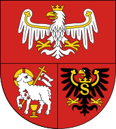 Coat of arms | |
.png) Location within Poland | |
 Division into counties | |
| Coordinates (Olsztyn): 53°47′N 20°30′E | |
| Country | |
| Capital | Olsztyn |
| Counties | 2 cities, 19 land counties *
|
| Government | |
| • Voivode | Artur Chojecki (PiS) |
| • Marshal | Gustaw Brzezin (PSL) |
| Area | |
| • Total | 24,191.8 km2 (9,340.5 sq mi) |
| Population (31-12-2014) | |
| • Total | 1,443,967 |
| • Density | 60/km2 (150/sq mi) |
| • Urban | 856,559 |
| • Rural | 570,532 |
| ISO 3166 code | PL-28 |
| Vehicle registration | N |
| HDI (2017) | 0.825[1] very high · 16th |
| Website | www |
| |
The Warmian-Masurian Voivodeship was created on January 1, 1999, from the entire Olsztyn Voivodeship, the western half of Suwałki Voivodeship and part of Elbląg Voivodeship, pursuant to the Polish local government reforms adopted in 1998. The province's name derives from two historic regions, Warmia and Masuria.
The province borders the Podlaskie Voivodeship to the east, the Masovian Voivodeship to the south, the Kuyavian-Pomeranian Voivodeship to the south-west, the Pomeranian Voivodeship to the west, the Vistula Lagoon to the northwest, and the Kaliningrad Oblast (an exclave of Russia) to the north.
History
The region was originally inhabited by the Old Prussian clan of the Warmians from whom the name Warmia originated. During the northern Crusade, the Old Prussians were conquered by the Teutonic Order and their land was granted to the order by the pope and the region became part of the State of the Teutonic Order. The Order encouraged the colonization by German settlers in Warmia (Ostsiedlung) and Polish colonists from the region of Masovia, called Masurians (Mazurzy), hence the name Masuria. The Old Prussians became assimilated into the newcomers and thus became extinct.
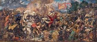
During the Teutonic rule, the region experienced a process of urbanization and economic boost due to the expansion of the Hanseatic League into the region. The Order later attacked their former ally Poland and conquered the region of Pomerelia, thus entered a long-lasting conflict with Poland, which subsequently entered an alliance with Lithuania. In Masuria, the Poles and Lithuanians defeated the Order at the Battle of Grunwald. The wars finally resulted in a rebellion of the urban population of Pomerelia and Warmia, who were affected by the Teuton's numerous wars; upon their request the region was incorporated to Poland by King Casimir IV Jagiellon, and after the Thirteen Years' War it remained under Polish suzerainty, but was divided into two parts: Elbląg and Warmia were incorporated directly into the Kingdom of Poland, Masuria became a Polish fief under the control of the Teutonic Order.
The state of the Teutonic Order ceased to exist in 1525 when Grandmaster Albert Hohenzollern introduced secularisation, proclaimed the Duchy of Prussia and became a vassal of Sigismund I of Poland. The Prussian line of Hohenzollern was extinct by 1618 with the death of Albert Frederick and the Duchy was inherited by the Brandenburgian line; Prussia simultaneously entered a personal union with the electorate of Brandenburg known as Brandenburg-Prussia, remaining under Polish suzerainty until the Treaty of Oliva in 1660. The throne was inherited by Frederick I of Prussia who wanted to unite the Duchy with Brandenburg and also wanted to proclaim himself king of Prussia and therefore participated in the Russian-initiated Partitions of Poland in which Warmia was annexed by the Kingdom of Prussia, and henceforth became part of the newly established province of East Prussia until 1945. Together with the rest of the Kingdom, the region became part of the North German Confederation, the German Empire, the Weimar Republic, and Nazi Germany. After the end of World War II, both the German as well as the Slavic Masurian population were expelled by the Polish government. In 1914, the province turned into a battlefield, seeing notable battles such as the Battle of Tannenberg as part of the Eastern Front of World War I.

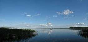
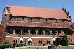
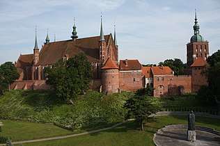
Amongst the most visited sights is the Masurian Lake District, which contains more than 2,000 lakes, including the largest lakes of Poland, Śniardwy and Mamry. Other recognizable landmarks are the Warmian castles (Lidzbark Warmiński Castle, Pieniężno Castle, Olsztyn Castle) and the Cathedral Hill in Frombork, where Polish astronomer Nicolaus Copernicus lived and worked. The Lidzbark Warmiński Castle was later the residence of Ignacy Krasicki, nicknamed the Prince of Polish Poets. The Grunwald battlefield in Masuria is site of the annual reenactment of one of the largest battles of Medieval Europe. Święta Lipka in Masuria and Gietrzwałd in Warmia are popular pilgrimage sites.
The Warmian-Masurian Voivodeship has the largest number of ethnic Ukrainians living in Poland[3] due to forced relocations (such as Operation Vistula) carried out by the Soviet and Polish Communist authorities.
Ethnic and religious structure
In year 1824, shortly before its merger with West Prussia, the population of East Prussia was 1,080,000 people.[4] Of that number, according to Karl Andree, Germans were slightly more than half, while 280,000 (~26%) were ethnically Polish and 200,000 (~19%) were ethnically Lithuanian.[5] As of year 1819 there were also 20,000 strong ethnic Curonian and Latvian minorities as well as 2,400 Jews, according to Georg Hassel.[6] Similar numbers are given by August von Haxthausen in his 1839 book, with a breakdown by county.[7] However, the majority of East Prussian Polish and Lithuanian inhabitants were Lutherans, not Roman Catholics like their ethnic kinsmen across the border in the Russian Empire. Only in Southern Warmia (German: Ermland) Catholic Poles - so called Warmiaks (not to be confused with predominantly Protestant Masurians) - comprised the majority of population, numbering 26,067 people (~81%) in county Allenstein (Polish: Olsztyn) in 1837.[7] Another minority in 19th century East Prussia, were ethnically Russian Old Believers, also known as Philipponnen - their main town was Eckersdorf (Wojnowo).[8][9][10]
In year 1817, East Prussia had 796,204 Evangelical Christians, 120,123 Roman Catholics, 864 Mennonites and 2,389 Jews.[11]
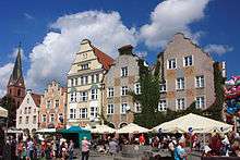
Cities and towns
.jpg)
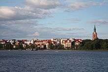
The Voivodeship contains 49 cities and towns. These are listed below in descending order of population (according to official figures for 2006):[12]
- Olsztyn (176,522)
- Elbląg (127,055)
- Ełk (56,156)
- Ostróda (33,419)
- Iława (32,326)
- Giżycko (29,667)
- Kętrzyn (28,000)
- Szczytno (25,680)
- Bartoszyce (25,423)
- Mrągowo (21,772)
- Działdowo (20,824)
- Pisz (19,332)
- Braniewo (17,875)
- Lidzbark Warmiński (16,390)
- Olecko (16,169)
- Nidzica (14,761)
- Morąg (14,497)
- Gołdap (13,641)
- Pasłęk (12,179)
- Węgorzewo (11,638)
- Nowe Miasto Lubawskie (11,036)
- Dobre Miasto (10,489)
- Biskupiec (10,348)
- Orneta (9,380)
- Lubawa (9,328)
- Lidzbark (8,261)
- Olsztynek (7,591)
- Barczewo (7,401)
- Orzysz (5,804)
- Susz (5,733)
- Reszel (5,098)
- Ruciane-Nida (4,894)
- Korsze (4,632)
- Górowo Iławeckie (4,554)
- Biała Piska (4,006)
- Mikołajki (3,848)
- Jeziorany (3,376)
- Ryn (3,006)
- Pieniężno (2,915)
- Tolkmicko (2,731)
- Miłakowo (2,665)
- Pasym (2,550)
- Frombork (2,529)
- Bisztynek (2,493)
- Miłomłyn (2,305)
- Kisielice (2,208)
- Zalewo (2,152)
- Sępopol (2,015)
- Młynary (1,837)
Administrative division
Warmian-Masurian Voivodeship is divided into 21 counties (powiaty): 2 city counties and 19 land counties. These are further divided into 116 gminas.
The counties are listed in the following table (ordering within categories is by decreasing population).
| English and Polish names |
Area (km²) |
Population (2006) |
Seat | Other towns | Total gminas |
| City counties | |||||
| Olsztyn | 88 | 176,522 | 1 | ||
| Elbląg | 80 | 127,055 | 1 | ||
| Land counties | |||||
| Olsztyn County powiat olsztyński |
2,840 | 113,529 | Olsztyn * | Dobre Miasto, Biskupiec, Olsztynek, Barczewo, Jeziorany | 12 |
| Ostróda County powiat ostródzki |
1,765 | 105,286 | Ostróda | Morąg, Miłakowo, Miłomłyn | 9 |
| Iława County powiat iławski |
1,385 | 89,960 | Iława | Lubawa, Susz, Kisielice, Zalewo | 7 |
| Ełk County powiat ełcki |
1,112 | 84,760 | Ełk | 5 | |
| Szczytno County powiat szczycieński |
1,933 | 69,289 | Szczytno | Pasym | 8 |
| Kętrzyn County powiat kętrzyński |
1,213 | 66,165 | Kętrzyn | Reszel, Korsze | 6 |
| Działdowo County powiat działdowski |
953 | 65,110 | Działdowo | Lidzbark | 6 |
| Bartoszyce County powiat bartoszycki |
1,309 | 61,354 | Bartoszyce | Górowo Iławeckie, Bisztynek, Sępopol | 6 |
| Pisz County powiat piski |
1,776 | 57,553 | Pisz | Orzysz, Ruciane-Nida, Biała Piska | 4 |
| Giżycko County powiat giżycki |
1,119 | 56,863 | Giżycko | Ryn | 6 |
| Elbląg County powiat elbląski |
1,431 | 56,412 | Elbląg * | Pasłęk, Tolkmicko, Młynary | 9 |
| Mrągowo County powiat mrągowski |
1,065 | 50,087 | Mrągowo | Mikołajki | 5 |
| Braniewo County powiat braniewski |
1,205 | 43,781 | Braniewo | Pieniężno, Frombork | 7 |
| Nowe Miasto County powiat nowomiejski |
695 | 43,388 | Nowe Miasto Lubawskie | 5 | |
| Lidzbark County powiat lidzbarski |
924 | 43,006 | Lidzbark Warmiński | Orneta | 5 |
| Olecko County powiat olecki |
874 | 34,215 | Olecko | 4 | |
| Nidzica County powiat nidzicki |
961 | 33,955 | Nidzica | 4 | |
| Gołdap County powiat gołdapski |
772 | 26,989 | Gołdap | 3 | |
| Węgorzewo County powiat węgorzewski |
693 | 23,641 | Węgorzewo | 3 | |
| * seat not part of the county | |||||
Protected areas
Protected areas in Warmian-Masurian Voivodeship include eight areas designated as Landscape Parks, as listed below:
- Brodnica Landscape Park (partly in Kuyavian-Pomeranian Voivodeship)
- Dylewo Hills Landscape Park
- Elbląg Upland Landscape Park
- Górzno-Lidzbark Landscape Park (partly in Kuyavian-Pomeranian and Masovian Voivodeships)
- Iława Lake District Landscape Park (partly in Pomeranian Voivodeship)
- Masurian Landscape Park
- Puszcza Romincka Landscape Park
- Wel Landscape Park
The Łuknajno Lake nature reserve (part of Masurian Landscape Park) is a protected wetland site under the Ramsar convention, as well as being designated by UNESCO as a biosphere reserve.
International relations
Gallery
- Popular attractions and tourist destinations
 St. James' Cathedral in Olsztyn
 Reszel historic city center
 Sanctuary of Saint Mary in Święta Lipka
 Palace in Smolajny, former summer residence of Ignacy Krasicki
 Birthplace of composer Feliks Nowowiejski in Barczewo
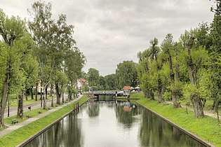 Łuczański Canal and the swing bridge in Giżycko
 Grunwald battlefield
See also
References
- "Sub-national HDI - Area Database - Global Data Lab". hdi.globaldatalab.org. Retrieved 2018-09-13.
- Arkadiusz Belczyk,Tłumaczenie polskich nazw geograficznych na język angielski [Translation of Polish Geographical Names into English], 2002-2006.
- (in Polish) Mniejszości narodowe i etniczne w Polsce on the pages of Polish Ministry of Internal Affairs and Administration. Retrieved on 9 September 2007
- Plater, Stanisław (1825). Jeografia wschodniéy części Europy czyli Opis krajów przez wielorakie narody słowiańskie zamieszkanych: obejmujący Prussy, Xsięztwo Poznańskie, Szląsk Pruski, Gallicyą, Rzeczpospolitę Krakowską, Krolestwo Polskie i Litwę (in Polish). Wrocław: u Wilhelma Bogumiła Korna. p. 17.
- Andree, Karl (1831). Polen: in geographischer, geschichtlicher und culturhistorischer Hinsicht (in German). Verlag von Ludwig Schumann. p. 218.
- Hassel, Georg (1823). Statistischer Umriß der sämmtlichen europäischen und der vornehmsten außereuropäischen Staaten, in Hinsicht ihrer Entwickelung, Größe, Volksmenge, Finanz- und Militärverfassung, tabellarisch dargestellt; Erster Heft: Welcher die beiden großen Mächte Österreich und Preußen und den Deutschen Staatenbund darstellt (in German). Verlag des Geographischen Instituts Weimar. p. 41.
- Haxthausen, August (1839). Die Ländliche Verfassung in den Einzelnen Provinzen der Preussischen Monarchie (in German). pp. 75–91.
- "Monastery of the Dormition of the Mother of God in Wojnowo (Eckersdorf)". wojnowo.net.
- Tetzner, Franz (1902). Die Slawen in Deutschland: beiträge zur volkskunde der Preussen, Litauer und Letten, der Masuren und Philipponen, der Tschechen, Mährer und Sorben, Polaben und Slowinzen, Kaschuben und Polen. Braunschweig: Verlag von F. Vieweg. pp. 212–248.
- "Old Believers in Poland - historical and cultural information". Poland's Linguistic Heritage.
- Hoffmann, Johann Gottfried (1818). Übersicht der Bodenfläche und Bevölkerung des Preußischen Staates : aus den für das Jahr 1817 mtlich eingezogenen Nachrichten. Berlin: Decker. p. 51.
- Stat.gov.pl
- "Podolsk sister cities". Translate.google.com. Retrieved 2010-04-29.
External links
| Wikimedia Commons has media related to Warmińsko-Mazurskie. |
Places adjacent to Warmian-Masurian Voivodeship | |
|---|---|
| City counties | | |
|---|---|---|
| Land counties | ||
Voivodeships of Poland | ||
|---|---|---|
| Authority control |
|
|---|