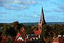
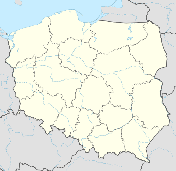
Bartoszyce
Bartoszyce (pronounced Barto-shitse [bartɔˈʂɨt͡sɛ] (![]()
![]()
Bartoszyce | |
|---|---|
| |
 Flag  Coat of arms | |
 Bartoszyce 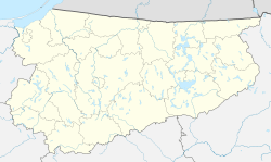 Bartoszyce | |
| Coordinates: 54°15′N 20°48′E | |
| Country | |
| Voivodeship | |
| County | Bartoszyce County |
| Gmina | Bartoszyce (urban gmina) |
| Established | 1240 |
| Town rights | 1326 |
| Government | |
| • Mayor | Piotr Petrykowski |
| Area | |
| • Total | 11 km2 (4 sq mi) |
| Population (2019-06-30[1]) | |
| • Total | 23,482 |
| • Density | 2,100/km2 (5,500/sq mi) |
| Time zone | UTC+1 (CET) |
| • Summer (DST) | UTC+2 (CEST) |
| Postal code | 11-200 |
| Area code(s) | +48 89 |
| Car plates | NBA |
| Website | http://www.bartoszyce.pl |
Geographical location
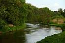
Bartoszyce lies on the left shore of river Łyna River in a valley, approximately 90 kilometres (56 miles) east of Elbląg and 55 kilometres (34 miles) south of Kaliningrad, at an altitude of 3 metres (9.8 feet) above sea level.
History
Middle Ages

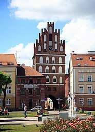
Around 1241 the Teutonic Knights (the monastic German Order) constructed a castle on the left shore of the Łyna River on the border between the Old Prussian regions of Natangia and Bartia.[2] The castle was part of the district (Komturei) of Balga. It was first composed of stone houses, palisades, and earthworks and later built of bricks.
Besieged by the native Old Prussians for four years during an uprising beginning in 1260, the castle was destroyed in 1264. The Order rebuilt it shortly afterward, but it was besieged by another Baltic group, the Sudovians, in 1273. After the Old Prussian uprisings ended, the Knights rebuilt the Ordensburg out of stone from 1274–80.[2] During the 14th and 15th centuries, the castle was managed by the Komtur (administrator) of Balga.
Thereafter, a settlement developed near the castle on the right shore of the Alle River opposite the castle. First documented in 1326 under the name Rosenthal, it received town privileges from the Teutonic Grand Master Luther von Braunschweig in 1332. After that the name was changed to Bartenstein and the settlement of Rosenthal below the castle on the left shore of the river was relocated, as the left side had become too endangered by warfare.[2] [3] Poles settled in sizeable numbers in Bartenstein from the 14th to the 17th century. The town's Polish residents used the Polish names Bartoszyce and Barsztyn.[3] The town's Teutonic Order administrator (German: Komtur), Henning Schindekopf of Balga, began construction of a wall around the town in 1353.[2]
During the Thirteen Years' War between the Prussian Confederation, allied with the Polish Crown, and the State of the Teutonic Order (1454–66), the town sided with Poland and the Confederation. The Teutonic castle was destroyed at the beginning of the war and was not rebuilt afterward.[2] However, the residents of Bartenstein became reconciled with the Teutonic Knights in 1460. After the peace treaty signed in Toruń (German: Thorn) in 1466, the town came under Polish suzerainty as a fief, remaining part of the State of the Teutonic Order. To stabilize the Order's financial situation, the Order sold the ruined castle's farmyard and meadows to Wend von Eulenburg in 1469; the entire manor of Bartenstein was sold in 1513 to Heinrich Reuß von Plauen (not the Grand Master).[2]
Modern era
With the secularization of the Teutonic Order's Prussian territories in 1525, the town became part of the Duchy of Prussia, established with the consent of the Polish king Sigismund I the Old, as a vassal state of the Polish Crown. The town converted to Protestantism in the same year during the Protestant Reformation.[2]
Bartenstein became part of the secular Kingdom of Prussia in 1701 and the Prussian Province of East Prussia in 1773. During the Napoleonic Wars, Prussia and the Russian Empire signed a treaty of alliance in the town on 26 April 1807,[4] the Treaty of Bartenstein. Administrative reform following the Napoleonic Wars placed Bartenstein within East Prussia's Landkreis Friedland in 1818.
.jpg)
The Lyck-Bartenstein (Ełk–Bartoscyze) train line ran through the town in 1868, leading to the establishment of industries, including an iron foundry, a machine factory, and a train-car factory. It was also noted for its oak trade. A garrison town for the Prussian Army, Bartenstein was the seat of the district court. Because it had grown to become the largest town in Landkreis Friedland during the 19th century, the town was made the district capital in 1902. Landkreis Friedland was renamed Landkreis Bartenstein in 1927. The foundations of the old castle were used in the construction of the administrative seat; this building was destroyed in 1945.[2]
In January 1945 during World War II, the town was 50% destroyed in fighting between German forces and the Soviet Red Army. As a result of border changes promulgated at the Potsdam Conference (July-August 1945), the town and the area was assigned to Poland. Remaining German residents who had survived were either evacuated or later expelled, and the town was repopulated with Poles.
The town, renamed Bartoszyce, was in Olsztyn Voivodeship from 1975–1998. It became part of the Warmian-Masurian Voivodeship in 1999.
Number of inhabitants by year

| Year | Number |
|---|---|
| 1729 | 2,000 |
| 1785 | 2,780 |
| 1831 | 3,603 |
| 1875 | 6,460 |
| 1880 | 7,132 |
| 1890 | 6,442 |
| 1905 | 6,805 |
| 1925 | 7,890 |
| 1933 | 8,717 |
| 1939 | 11,268 |
| 2009 | 24,994 |
Note that the above table is based on primary, potentially biased, sources.[5][6]
Notable residents
- Matthäus Waissel (1540–1602), German theologian, lutist, author
- Max Baginski (1864–1943), German–American anarchist
- Hans Koch (1893–1945), German anti–Nazi resistance fighter
- Erwin Geschonneck (1906–2008), German actor
- Günther Schack (1917–2003), German fighter pilot
- Hans-Joachim Reske (1940), German athlete
- Zbigniew Lubiejewski (1949), Polish volleyball player
- Marek Daćko (1991), Polish handball player
- Mateusz Czunkiewicz (1996), Polish volleyball player
Twin towns — sister cities
Popular culture
The town is the location of a scene in Leo Tolstoys War and Peace. [8]:228
References
- "Population. Size and structure and vital statistics in Poland by territorial division in 2019. As of 30th June". stat.gov.pl. Statistics Poland. 2019-10-15. Retrieved 2020-02-14.
- Ostpreußen.net. Geschichte der Stadt Bartoszyce - Bartenstein. Accessed 1 April 2007. (in German)
- "Bartoszyce, eMazury" (in Polish). Retrieved June 7, 2019.
- Der Große Brockhaus, 15th edition, Vol. 2, Leipzig 1929, p. 333.
- Johann Friedrich Goldbeck: Vollständige Topographie des Königreichs Preußen. Part I: Topographie von Ost-Preussen, Marienwerder 1785, p. 18, no. 1.
- Michael Rademacher: Deutsche Verwaltungsgeschichte Provinz Ostpreußen, Kreis Friedland/Bartenstein (2006).
- "Miasta Partnerskie". bartoszyce.pl (in Polish). Bartoszyce. Retrieved 2020-02-14.
- Tolstoy, Leo (1949). War and Peace. Garden City: International Collectors Library.
External links
| Wikimedia Commons has media related to Bartoszyce. |
| Wikisource has the text of the 1911 Encyclopædia Britannica article Bartenstein. |
- Municipal website (in Polish)
- History of Bartoszyce (in Polish)
- Geschichte der Stadt Bartoszyce - Bartenstein (in German)
- Photos of Bartoszyce(in Polish)
| Urban gminas |
|  |
|---|---|---|
| Urban-rural gminas | ||
| Rural gminas | ||

| Authority control |
|
|---|