U.S. Route 95 in California
U.S. Route 95 (US 95) is a United States Numbered Highway, stretching from the Mexican border in San Luis, Arizona to the Canadian border near Eastport, Idaho. The California portion of US 95 traverses through the far eastern edges of both Riverside and San Bernardino counties. US 95 serves Blythe and Needles and junctions with SR 62 at Vidal Junction.
| ||||
|---|---|---|---|---|
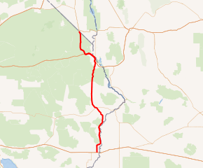
US 95 highlighted in red | ||||
| Route information | ||||
| Defined by Streets and Highways Code § 395 | ||||
| Maintained by Caltrans | ||||
| Length | 116.721 mi[1] (187.844 km) Length does not reflect the distance along I-10 and I-40 overlaps. | |||
| Existed | 1930s–present | |||
| Major junctions | ||||
| South end | ||||
| North end | ||||
| Location | ||||
| Counties | Riverside, San Bernardino | |||
| Highway system | ||||
| ||||
.svg.png)
The route overlaps with two Interstate highways, specifically I-10 near Blythe and I-40 near Needles.
Route description
US 95, running concurrently with I-10, crosses the Colorado River from the state of Arizona and enters the city of Blythe. The highway exits I-10 at Intake Boulevard and turns due north, leaving the city limits. A few miles north, US 95 turns northeast to parallel the Colorado River. The route passes through the Big Maria Mountains and the Riverside Mountains before entering San Bernardino County.[2]
Upon entering San Bernardino County, US 95 turns away from the Colorado River, heading northwest towards Vidal Junction, the junction with SR 62 in the Vidal Valley. The highway continues north through the Chemehuevi Valley and the Chemehuevi Mountains before entering the city of Needles after several miles. After passing the Needles Municipal Airport, US 95 merges onto I-40 westbound and continues through Needles on the freeway. US 95 exits from I-40 west of Needles and continues northwest to Searchlight Junction, where US 95 continues north at the junction with the old routing of US 66. The highway continues north, east of Homer Mountain, to the Nevada state line.[3]
US 95 is part of the California Freeway and Expressway System,[4] and a small portion near I-10 and the portion north of I-40 are part of the National Highway System,[5] a network of highways that are considered essential to the country's economy, defense, and mobility by the Federal Highway Administration.[6] US 95 is eligible for the State Scenic Highway System,[7] but it is not officially designated as a scenic highway by the California Department of Transportation.[8]
History
Route 146 was designated by the California State Legislature in 1933 and contained the portion from Blythe to the Nevada state line.[9] US 95 was extended south from its routing in Idaho by AASHO through Searchlight and Needles to Blythe on June 28, 1939; the routing became effective at the start of 1940.[10] In the 1964 state highway renumbering, the law was changed to reflect the designation as US 95.[11]
Major intersections
Except where prefixed with a letter, postmiles were measured on the road as it was in 1964, based on the alignment that existed at the time, and do not necessarily reflect current mileage. R reflects a realignment in the route since then, M indicates a second realignment, L refers an overlap due to a correction or change, and T indicates postmiles classified as temporary (for a full list of prefixes, see the list of postmile definitions).[1] Segments that remain unconstructed or have been relinquished to local control may be omitted. The numbers reset at county lines; the start and end postmiles in each county are given in the county column.
| County | Location | Postmile [1][12][13] | Exit [14] | Destinations | Notes |
|---|---|---|---|---|---|
| Riverside RIV R156.49[N 1]-36.20 | Blythe | R156.49[N 1] | Continuation into Arizona | ||
| R156.10[N 1] | 243 | Riviera Drive (I-10 Bus. west) | Former US 60 west | ||
| North end of freeway on I-10 | |||||
| R154.16[N 1] L0.16 | Interchange; north end of I-10 overlap; I-10 exit 241 | ||||
| L0.39 0.00 | Hobsonway (I-10 Bus.) – Blythe | Former US 60 | |||
| San Bernardino SBD 0.00-80.45 | Vidal Junction | 9.68 | |||
| | 37.30 | Havasu Lake Road – Chemehuevi Valley, Lake Havasu | |||
| | | South end of CR 66 overlap; former US 66 east | |||
| Needles | 57.28 R143.76[N 2] | Interchange; south end of I-40 overlap; north end of CR 66 overlap; former US 66 west; I-40 exit 148 | |||
| South end of freeway on I-40 | |||||
| R142.37[N 2] | 142 | J Street – Downtown | |||
| R141.01[N 2] | 141 | West Broadway (I-40 Bus. east / CR 66) / River Road | Former US 66 | ||
| R139.11[N 2] | 139 | River Road Cutoff (CR 66 east) | Southbound exit and northbound entrance; south end of CR 66 overlap | ||
| | North end of freeway on I-40 | ||||
| | R132.73[N 2] R57.21 | Interchange; north end of I-40 overlap; I-40 exit 133 | |||
| Arrowhead Junction | 63.94 | Goffs Road (CR 66 west) – Goffs | North end of CR 66 overlap; former US 66 west | ||
| | 80.45 | Continuation into Nevada | |||
1.000 mi = 1.609 km; 1.000 km = 0.621 mi
| |||||
See also

References
- California Department of Transportation. "State Truck Route List". Sacramento: California Department of Transportation. Archived from the original (XLS file) on June 30, 2015. Retrieved June 30, 2015.
- Riverside County Street Atlas (Map). Thomas Brothers. 2008.
- San Bernardino County Street Atlas (Map). Thomas Brothers. 2008.
- "Article 2 of Chapter 2 of Division 1 of the California Streets and Highways Code". Sacramento: California Office of Legislative Counsel. Retrieved February 6, 2019.
- Federal Highway Administration (March 25, 2015). National Highway System: California (South) (PDF) (Map). Scale not given. Washington, DC: Federal Highway Administration. Retrieved October 7, 2017.
- Natzke, Stefan; Neathery, Mike & Adderly, Kevin (June 20, 2012). "What is the National Highway System?". National Highway System. Washington, DC: Federal Highway Administration. Retrieved July 1, 2012.
- "Article 2.5 of Chapter 2 of Division 1 of the California Streets & Highways Code". Sacramento: California Office of Legislative Counsel. Retrieved February 6, 2019.
- California Department of Transportation (August 2019). "Officially Designated State Scenic Highways and Historic Parkways" (XLSX). Sacramento: California Department of Transportation. Retrieved October 7, 2017.
- California State Assembly. "An act to amend sections 2, 3 and 5 and to add two sections to be numbered 6 and 7 to an act entitled 'An act to provide for the acquisition of rights of way for and the construction, maintenance..." Fiftieth Session of the Legislature. Statutes of California. State of California. Ch. 767 p. 2034–2042.
- "U.S. 95 and Idaho's North and South Highway". Highway History. Federal Highway Administration. October 17, 2008. Retrieved March 20, 2010.
- California State Assembly. "An act to add Section 253 and Article 3 (commencing with Section 300) to Chapter 2 of Division 1 of, and to repeal Section 253 and Article 3 (commencing with Section 300) of Chapter 2 of Division 1 of, the..." 1963 Session of the Legislature. Statutes of California. State of California. Ch. 385 p. 1182.
- California Department of Transportation (July 2007). "Log of Bridges on State Highways". Sacramento: California Department of Transportation.
- California Department of Transportation, All Traffic Volumes on CSHS, 2005 and 2006
- California Department of Transportation, California Numbered Exit Uniform System, Interstate 10 Freeway Interchanges Interstate 40 Freeway Interchanges
External links
- California @ AARoads.com - U.S. Route 95
- Caltrans: Route 95 highway conditions
- California Highways: US 95
| Wikimedia Commons has media related to U.S. Route 95 in California. |
| Previous state: Arizona |
California | Next state: Nevada |