U.S. Route 12 in Wisconsin
U.S. Highway 12 (US 12 or Highway 12) in the U.S. state of Wisconsin runs east–west across the western to southeast portions of the state. It enters from Minnesota running concurrently with Interstate 94 (I-94) at Hudson, parallels the Interstate to Wisconsin Dells, and provides local access to cities such as Menomonie, Eau Claire, Black River Falls, Tomah and Mauston. It then provides an alternative route for traffic between northwestern Wisconsin and Madison and is the anchor route for the Beltline Highway around Madison. Finally, it serves southeastern Wisconsin, connecting Madison with Fort Atkinson, Whitewater, Elkhorn and Lake Geneva. The West Beltline Highway and the segment between Elkhorn and Genoa City are freeways, and the segment between Sauk City and Middleton is an expressway. The remainder of the road is a two-lane surface road or an urban multi-lane arterial. Between Hudson and west of Warrens, the road closely parallels the former main line of the Omaha Road, now operated by Union Pacific Railroad.
| ||||
|---|---|---|---|---|
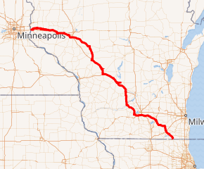
US 12 highlighted in red | ||||
| Route information | ||||
| Maintained by WisDOT | ||||
| Length | 339.40 mi[1] (546.21 km) | |||
| Existed | 1926–present | |||
| History | Designated in 1917 as WIS 12 | |||
| Major junctions | ||||
| West end | ||||
| East end | ||||
| Location | ||||
| Counties | St. Croix, Dunn, Chippewa, Eau Claire, Clark, Jackson, Monroe, Juneau, Sauk, Dane, Jefferson, Rock, Walworth | |||
| Highway system | ||||
| ||||

Route description
Hudson to Lake Delton
US 12 crosses the St. Croix River from Minnesota concurrent with I-94 into St. Croix County. Wisconsin Highway 35 (WIS 35) joins both routes upon their entry into Wisconsin and exits south three miles (5 km) east. US 12 leaves I-94 one mile (1.6 km) further east from the eastern WIS 35 exit, treks two miles (3 km) north and parallels the interstate. The highway crosses WIS 65 in Roberts and passes through Hammond over a fifteen-mile (24 km) segment to Baldwin, where it crosses US 63. US 12 passes through Woodville four miles (6 km) east of Baldwin and crosses WIS 128 in Wilson, two miles (3 km) west of the Dunn County line.[2] Roughly three miles into Dunn County, US 12 passes through Knapp, Wisconsin, then turns southeastward, connecting with WIS 79 six miles (10 km) further; it then joins WIS 25 (North Broadway Street) to the south in Menomonie. US 12 turns east onto WIS 29 (Main Street East) in downtown Menomonie, and the two routes follow Stout Road east out of the city.[3] The highways meet an interchange with I-94, then split one half of a mile east in Elk Mound at the junction with WIS 40. US 12 passes through Elk Mound and enters Eau Claire County[4]
US 12 merges with WIS 312 east (North Crossing) for two miles (3 km) before turning south onto Clairemont Avenue, bypassing downtown Eau Claire to the south and west. WIS 37 joins with US 12 on the southwest side of the city. Access to WIS 93 is provided via US 53. The interchange between US 12 and US 53 in Altoona is Wisconsin's only single-point urban interchange.[5] US 12 continues east out of the Eau Claire metropolitan area and passes through Fall Creek, where it turns southeastward to join WIS 27 south in Augusta. The two highways briefly join US 10 on the Jackson County line in Fairchild[6] US 12 and WIS 27 turn southward and pass through Humbird in Clark County and into Jackson County.[7]
US 12 and WIS 27 cross WIS 95 in Merrillan and WIS 54 in Black River Falls. US 12 and WIS 27 also split in Black River Falls. US 12 follows I-94 to the southeast past Millston and into Monroe County.[8] The highway crosses I-94 (with no access) south of Kirby and junctions with WIS 21 on the north side of Tomah at an interchange with the interstate. US 12 passes through Tomah and joins with WIS 16 on the south side at the junction with WIS 131 near Mill Bluff State Park. The highways continue paralleling I-90 and I-94 southeast and pass through Oakdale and into Juneau County.[8]
US 12 and WIS 16 pass through Camp Douglas and cross WIS 80 in New Lisbon. The highways then junction with WIS 58 and WIS 82 in Mauston as they continue southeast. The routes trek eastward and pass through Lyndon Station, where Rocky Arbor State Park is located. The highways turn southeast again and cross the Interstates into Sauk County and Wisconsin Dells.[9] WIS 16 turns east onto WIS 13 north as WIS 23 west turns south onto US 12. These highways follow the Wisconsin Dells Parkway south into the heart of the Wisconsin Dells tourism district,[10] — passing such attractions as Noah's Ark Waterpark,[11] the Wisconsin Ducks boat tours,[12] Kalahari Resort, Mt. Olympus Water & Theme Park, Wilderness Territory, and Tommy Bartlett's Thrill Show.[13] WIS 23 turns west onto Monroe Ave as US 12 turns southeast and crosses the Interstates.[14]
Lake Delton to Cambridge
At the I-90/94 interchange, US 12 becomes a freeway that bypasses Baraboo. The section from I-90/94 to just south of Old Highway 33 is complete, and then U.S 12 joins its old alignment at a roundabout. WIS 33 joins the old US 12 alignment three miles (5 km) north of Baraboo; the routes split in West Baraboo at WIS 136. US 12 joins with WIS 159, a short highway that provides access to Devil's Lake State Park. Eventually, WisDOT will continue the Baraboo bypass freeway south of its current terminus at Old Highway 33, to just south of the Grasser Road overpass. Near the US 12/WI 159 intersection, the highway will become an expressway to just south of Ski Hi Road. The highway briefly becomes an expressway two miles south of WIS 159 for seven miles (11 km) as it approaches Sauk City. WIS 60 briefly joins US 12 in Sauk City and WIS 78 crosses the Wisconsin River concurrently with US 12 into Dane County.[14] US 12 becomes an expressway again at the county line and continues southeast, crossing WIS 19 at Springfield Corners. Just northwest of Middleton, the route becomes a freeway as it enters the Madison area along the West Beltline Highway.[15]
US 12 merges with US 14 at University Avenue. The freeway continues south and turns eastward at the interchange with CTH M and CTH S (Mineral Point Road). US 18 and US 151 join the beltline off Verona Road in southwestern Madison. The four routes travel concurrently for two miles (3 km), passing through interchanges with Todd Drive and Fish Hatchery Road before US 14 leaves south towards Janesville and US 151 north into downtown Madison via Park Street. The four-way concurrency was crossed by a railroad track at the surface until 2007. The crossing was isolated using Jersey barriers until that time.[16] The freeway also had several ramps, which contained driveways that accessed businesses.[17] US 12 and US 18 continue east into Monona and cross the Upper Mud Lake channel. The highways meet US 51 at Stoughton Road, then interchange with I-39 and I-90 on the southeast side of Madison.[18] US 12 and US 18 continue as an expressway east of the interstates, junctioning with WIS 73 in Deerfield and splitting, with US 12 turning southeast into Jefferson County in Cambridge.[15]
Cambridge to Genoa City
After leaving Cambridge, US 12 passes through Oakland and crosses WIS 26, WIS 89, and WIS 106 in Fort Atkinson. WIS 89 joins US 12 as the route turns southward to approach Whitewater, bypassing the city to the south into Walworth County. The route briefly enters Rock County before crossing into Walworth County[19] WIS 89 turns off US 12 at its junction with WIS 59. WIS 59 East follows US 12 briefly before turning north into the city. US 12 passes through La Grange and turns south at the junction with WIS 20 to follow WIS 67 south. US 12 turns southeast off WIS 67 onto a freeway northeast of Elkhorn. The highway crosses over WIS 11 with no access (although access is provided via nearby Interstate 43), then interchanges with I-43. Access for Lake Geneva is provided at WIS 120 and WIS 50 as US 12 passes the city to the east. The highway turns south into Genoa City, where the freeway ends and US 12 follows the crossroad into Illinois.
History
The entire route was originally signed as WIS 12 in 1917 prior to the creation of the U.S. highway system in 1926. Aside from changes resulting from the construction of freeways and US 12 being aligned on them, some differences exist between the original route and today's alignment. WIS 12 followed CTH E, a more southerly alignment, between Menomonie and Eau Claire. From Black River Falls, WIS 12 continued south to Shamrock and turned east to follow CTH O to Millston. WIS 12 ran southerly from Tomah along WIS 131 to CTH A and turned east onto the county road to pass through Hustler and Clifton to reach New Lisbon.[1][20]
The state originally planned to upgrade all of US 12 from Genoa City to Madison to freeway in anticipation of Illinois facilitating a toll road south of the state line. However, after Wisconsin started upgrading between Elkhorn and Genoa City, it was realized that the upgrades on the Illinois side had been shelved, due to community and environmental opposition (see FAP 420).
The route between Cambridge and Whitewater was upgraded to a straighter and flatter path for safety. A bypass of Whitewater was added in 2005, although the bypass is currently only two lanes. Upgrades to US 12 between Middleton and Sauk City were completed in 2005, but local opposition prevented most of the remaining route north of that point to Lake Delton from being constructed.[1]
In Wisconsin, the highway was designated as the Iron Brigade Memorial Highway in 1993 to honor the Civil War Union Army unit; it also has this designation in Michigan, Indiana and Illinois.[21][22][23][24]
Future
The portion of US 12 between Parmenter Street (the end of the Madison Beltline) to WIS 78/188 is being studied for future freeway conversion in two separate studies.[25][26] Additionally, WisDOT has long range plans for freeway conversion between the Baraboo bypass and WIS 78/188, including a bypass of Sauk City, however, there is no timetable.[27]
Major intersections
}}
| County | Location | mi | km | Exit[28] | Destinations | Notes | ||
|---|---|---|---|---|---|---|---|---|
| Washington | Lakeland | Continuation into Minnesota | ||||||
| St. Croix River | 0.00 | 0.00 | Minnesota–Wisconsin state line | |||||
| St. Croix | Hudson | 0.3 | 0.48 | 1 | Western end of WIS 35 overlap | |||
| 1.9 | 3.1 | 2 | ||||||
| 3.2 | 5.1 | 3 | Eastern end of WIS 35 overlap | |||||
| 3.9 | 6.3 | 4 | Eastern end of I-94 overlap | |||||
| Roberts | 11.6 | 18.7 | Western end of WIS 65 overlap | |||||
| 12.6 | 20.3 | Eastern end of WIS 65 overlap | ||||||
| Baldwin | 21.5 | 34.6 | Northern end of US 63 overlap | |||||
| 22.1 | 35.6 | Southern end of US 63 overlap | ||||||
| Town of Springfield | 31.0 | 49.9 | ||||||
| Dunn | Town of Menomonie | 42.7 | 68.7 | |||||
| Menomonie | 45.7 | 73.5 | Northern end of WIS 25 overlap | |||||
| 47.2 | 76.0 | Southern end of WIS 25 overlap | ||||||
| 47.5 | 76.4 | Western end of WIS 29 overlap | ||||||
| Town of Elk Mound | 59.4 | 95.6 | 60 | I-94 exit 52 | ||||
| 60.3 | 97.0 | 61 | Eastern end of WIS 29 overlap | |||||
| Chippewa |
No major junctions | |||||||
| Eau Claire | Eau Claire | 68.0 | 109.4 | Western end of WIS 312 overlap | ||||
| 70.6 | 113.6 | Eastern end of WIS 312 overlap | ||||||
| 74.3 | 119.6 | |||||||
| 76.9 | 123.8 | |||||||
| Altoona | 77.2 | 124.2 | US 53 exit 86 | |||||
| Augusta | 96.5 | 155.3 | Northern end of WIS 27 overlap | |||||
| Jackson | Town of Cleveland | 107.2 | 172.5 | Western end of US 10 overlap | ||||
| Clark | Town of Mentor | 109.7 | 176.5 | Eastern end of US 10 overlap | ||||
| Jackson | Merrillan | 120.9 | 194.6 | |||||
| Black River Falls | 131.2 | 211.1 | I-94 exit 115 | |||||
| 132.3 | 212.9 | Western end of WIS 54 overlap | ||||||
| 132.5 | 213.2 | Eastern end of WIS 54 overlap | ||||||
| Town of Brockway | 133.0 | 214.0 | Southern end of WIS 27 overlap | |||||
| Monroe | Tomah | 159.8 | 257.2 | I-94 exit 143; no entrance from westbound I-94 | ||||
| 160.0 | 257.5 | Provides access from westbound I-94 | ||||||
| 163.2 | 262.6 | Western end of WIS 16 overlap | ||||||
| 164.8 | 265.2 | I-90 exit 43 | ||||||
| Juneau | New Lisbon | 181.9 | 292.7 | Northern end of WIS 80 overlap | ||||
| 182.4 | 293.5 | Southern end of WIS 80 overlap | ||||||
| Mauston | 189.7 | 305.3 | ||||||
| Town of Lyndon | 207.3 | 333.6 | I-90 exit 85 | |||||
| Sauk | Wisconsin Dells | 209.5 | 337.2 | Eastern end of WIS 16 overlap; northern end of WIS 23 overlap | ||||
| Lake Delton | 212.2 | 341.5 | Southern end of WIS 23 overlap | |||||
| 214.0 | 344.4 | 211 | Signed as exits 211A (west) and 211B (east); I-90 exit 92 | |||||
| Town of Delton | 214.8 | 345.7 | 212 | |||||
| 216.7 | 348.7 | 214 | N. Reedsburg Road | Exit for Ho-Chunk Casino Wisconsin Dells | ||||
| 218.0 | 350.8 | 215 | Northern end of WIS 33 overlap | |||||
| West Baraboo | 220.8 | 355.3 | 218 | Southern end of WIS 33 overlap | ||||
| Baraboo | 221.8 | 357.0 | 219 | |||||
| Town of Prairie du Sac | 235.4 | 378.8 | Western end of WIS 60 overlap | |||||
| Sauk City | 237.1 | 381.6 | Eastern end of WIS 60 overlap; northern end of WIS 78 overlap | |||||
| Dane | Town of Roxbury | 237.6 | 382.4 | Southern end of WIS 78 overlap | ||||
| 237.9 | 382.9 | |||||||
| Town of Springfield | 246.5 | 396.7 | Western end of WIS 19 overlap | |||||
| 248.0 | 399.1 | Eastern end of WIS 19 overlap | ||||||
| Middleton | 252.8 | 406.8 | 249 | Parmenter Street | ||||
| 253.8 | 408.5 | 250 | ||||||
| 254.8 | 410.1 | 251A | Western end of US 14 overlap | |||||
| 254.8 | 410.1 | 251B | Parmenter Street | Westbound exit only | ||||
| Madison | 255.3 | 410.9 | 252 | Greenway Boulevard | ||||
| 256.4 | 412.6 | 253 | Old Sauk Road | |||||
| 257.4 | 414.2 | 254 | ||||||
| 258.6 | 416.2 | 255 | Gammon Road | |||||
| 260.2 | 418.8 | 257 | Whitney Way | |||||
| 261.4 | 420.7 | 258 | Western end of US 18 and US 151 overlaps. | |||||
| 261.9 | 421.5 | 258A | Seminole Highway | Westbound exit and eastbound entrance only; exit for UW Arboretum | ||||
| 263.0 | 423.3 | 259 | Todd Drive | |||||
| 263.8 | 424.5 | 260 | Eastbound exits signed 260A (south) and 260B (north) | |||||
| 264.5 | 425.7 | 261 | Eastern end of US 14 and US 151 overlaps | |||||
| 265.3 | 427.0 | 262 | ||||||
| 265.8 | 427.8 | 263 | John Nolen Drive | |||||
| Monona | 266.6 | 429.1 | 264 | |||||
| 268.1 | 431.5 | 265 | Monona Drive | |||||
| Madison | 269 | 433 | 266 | |||||
| 270.5 | 435.3 | 267 | Signed as exits 267A (east/south) and 267B (west/north); I-90 exit 142 | |||||
| Town of Cottage Grove | 274.5 | 441.8 | 272 | |||||
| Town of Deerfield | 281.1 | 452.4 | Interchange | |||||
| Cambridge | 284.2 | 457.4 | ||||||
| 284.3 | 457.5 | Eastern end of US 18 overlap | ||||||
| Jefferson | Fort Atkinson | 293.9 | 473.0 | |||||
| 295.3 | 475.2 | Southern end of WIS 26 Business overlap | ||||||
| 295.6 | 475.7 | Northern end of WIS 26 Business overlap, Northern end of WIS 89 overlap | ||||||
| 295.7 | 475.9 | |||||||
| Rock |
No major junctions | |||||||
| Walworth | Whitewater | 305.4 | 491.5 | Southern end of WIS 89 overlap; western end of WIS 59 overlap | ||||
| 307.8 | 495.4 | Eastern end of WIS 59 overlap | ||||||
| Town of La Grange | 317.6 | 511.1 | Northern end of WIS 67 overlap | |||||
| Elkhorn | 325.0 | 523.0 | Southern end of WIS 67 overlap | |||||
| 327– 327.4 | 526– 526.9 | 321 | Unnumbered exits via collector-distributor lane | |||||
| Lake Geneva | 334.4 | 538.2 | 328 | Northern end of WIS 120 overlap | ||||
| 335.5 | 539.9 | 330 | Southern end of WIS 120 overlap; eastbound exits signed 330A (west) and 330B (east) | |||||
| Town of Bloomfield | 340.6 | 548.1 | 335 | Pell Lake Road | ||||
| Genoa City | 344.7 | 554.7 | Continuation into Illinois | |||||
1.000 mi = 1.609 km; 1.000 km = 0.621 mi
| ||||||||
References
- Bessert, Chris. "Highways 10-19". Wisconsin Highways. Retrieved June 11, 2007.
- Wisconsin Department of Transportation (January 2014). St. Croix Co (PDF) (Map). 1:100,000. Madison: Wisconsin Department of Transportation. Archived from the original (PDF) on February 21, 2015. Retrieved June 8, 2015.
- Google (January 10, 2008). "Menomonie, WI, United States of America" (Map). Google Maps. Google. Retrieved January 10, 2008.
- Wisconsin Department of Transportation (January 2014). Dunn Co (PDF) (Map). 1:100,000. Madison: Wisconsin Department of Transportation. Archived from the original (PDF) on October 30, 2014. Retrieved June 8, 2015.
- Google (January 10, 2008). "Eau Claire, WI, United States of America" (Map). Google Maps. Google. Retrieved January 10, 2008.
- Wisconsin Department of Transportation (January 2014). Eau Claire Co (PDF) (Map). 1:100,000. Madison: Wisconsin Department of Transportation. Retrieved June 8, 2015.
- Wisconsin Department of Transportation (January 2014). Clark Co (PDF) (Map). 1:100,000. Madison: Wisconsin Department of Transportation. Archived from the original (PDF) on May 16, 2008. Retrieved June 8, 2015.
- Wisconsin Department of Transportation (January 2014). Monroe Co (PDF) (Map). 1:100,000. Madison: Wisconsin Department of Transportation. Archived from the original (PDF) on April 13, 2007. Retrieved June 8, 2015.
- Wisconsin Department of Transportation (January 2014). Juneau Co (PDF) (Map). 1:100,000. Madison: Wisconsin Department of Transportation. Archived from the original (PDF) on April 13, 2007. Retrieved June 8, 2015.
- Google (January 9, 2008). "Lake Delton, WI, United States of America" (Map). Google Maps. Google. Retrieved January 9, 2008.
- Noah's Ark Waterpark. "Noah's Ark Waterpark Wisconsin Dells". Noah's Ark Waterpark. Retrieved January 9, 2008.
- Wisconsin Duck Tours. "Original Wisconsin Ducks, Wisconsin Dells". Wisconsin Duck Tours. Retrieved January 9, 2008.
- Tommy Bartlett. "Tommy Bartlett Show". Tommy Bartlett. Retrieved January 9, 2008.
- Wisconsin Department of Transportation (January 2014). Sauk Co (PDF) (Map). 1:100,000. Madison: Wisconsin Department of Transportation. Archived from the original (PDF) on February 21, 2015. Retrieved June 8, 2015.
- Wisconsin Department of Transportation (January 2014). Dane Co (PDF) (Map). 1:100,000. Madison: Wisconsin Department of Transportation. Archived from the original (PDF) on June 14, 2011. Retrieved June 8, 2015.
- Neuhauser, Curt & Bie, Michael. "One Month and Counting: Beltline Project Begins April 30" (Press release). Madison: Wisconsin Department of Transportation. Archived from the original on September 29, 2007. Retrieved June 11, 2007.
- Jensen, David. "Unusual Sights in and around Madison". I Love Roads. Retrieved December 25, 2006.
- Google (January 17, 2008). "Madison, WI, United States of America" (Map). Google Maps. Google. Retrieved January 17, 2008.
- Wisconsin Department of Transportation (January 2014). Jefferson Co (PDF) (Map). 1:100,000. Madison: Wisconsin Department of Transportation. Archived from the original (PDF) on April 13, 2007. Retrieved June 8, 2015.
- Bauer, Kurt W. (March 1969). "Map 5: Original State Trunk Highway System in Wisconsin 1918" (Map). A Jurisdictional Highway System Plan For Milwaukee County. Southeast Wisconsin Regional Planning Commission. Retrieved January 10, 2008 – via Midwest Roads.
- Michigan Legislature (October 26, 2001). "Section 250.1048". Michigan Compiled Laws. Michigan Legislative Council. Retrieved August 15, 2012.
- Wisconsin Department of Transportation (June 4, 2010). "Commemorative Highways and Bridges". Wisconsin Department of Transportation. Retrieved August 15, 2012.
- Indiana Department of Transportation (June 16, 2009). "State Farm Sponsorship of Hoosier Helpers". Indiana Department of Transportation. Retrieved August 15, 2012.
- RoadDog (September 4, 2008). "US 12 In Illinois Gets New Name". American Road Forum. American Road Magazine. Retrieved August 15, 2012.
- Wisconsin Department of Transportation Southwest Region. "US 12 Freeway Conversion Study". Wisconsin Department of Transportation. Retrieved June 8, 2015.
- Wisconsin Department of Transportation Southwest Region. "US 12 Corridor Study". Wisconsin Department of Transportation. Retrieved June 8, 2015.
- Village of Prairie du Sac; Town of Prairie du Sac; Village of Sauk City (June 26, 2012). "Highway 12/PF and Airport Area Plan" (PDF). Village of Prairie du Sac, Wisconsin. Retrieved June 8, 2015.
- Wisconsin Department of Transportation. "Exit Numbers on US 12". Wisconsin Department of Transportation. Retrieved June 10, 2007.
External links
![]()
| Previous state: Minnesota |
Wisconsin | Next state: Illinois |